Area Overview for BS6 5AP
Photos of BS6 5AP


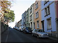

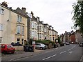

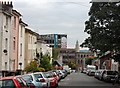
100 photos from this area
Area Information
Key information about the BS6 5AP including its size, population, and administrative classification.
- Area Type
- Postcode
- Area Size
- 5255 m²
- Population
- Not available
- Population Density
- Not available
House Prices in BS6 5AP
25
Properties
£344,562
Average Sold Price
£86,000
Lowest Price
£766,000
Highest Price
Showing 25 properties
| Address | Type | Beds | Baths | Last Sale Price | Last Sale Date | |
|---|---|---|---|---|---|---|
| 59 Belmont Road, Montpelier, Bristol, BS6 5AP | house | 4 | 2 | £750,000 | Nov 2024 | |
| 63 Belmont Road, Montpelier, Bristol, BS6 5AP | house | - | - | £693,650 | Dec 2018 | |
| 35 Belmont Road, Montpelier, Bristol, BS6 5AP | Detached | 4 | 2 | £766,000 | Apr 2017 | |
| 51 Belmont Road, Montpelier, Bristol, BS6 5AP | house | - | - | £410,000 | Jan 2012 | |
| 77 Belmont Road, Montpelier, Bristol, BS6 5AP | house | - | - | £148,780 | Jun 2009 | |
| 49 Belmont Road, Montpelier, Bristol, BS6 5AP | house | - | - | £425,000 | Jan 2009 | |
| 43 Belmont Road, Montpelier, Bristol, BS6 5AP | house | - | - | £451,500 | Aug 2007 | |
| 45 Belmont Road, Montpelier, Bristol, BS6 5AP | Semi-detached | - | - | £460,000 | May 2007 | |
| 61 Belmont Road, Montpelier, Bristol, BS6 5AP | Terraced | - | - | £245,000 | Aug 2003 | |
| 71 Belmont Road, Montpelier, Bristol, BS6 5AP | Terraced | - | - | £240,000 | Apr 2003 |
Page 1 of 3
Energy Efficiency in BS6 5AP
Amenities
Schools
| Rank | School | Type | Entry gender | Ages |
|---|
Explore more schools in this area
Go to Schools tabDemographics
Household Size
Two person
most common
Accommodation Type
Flats
most common
Tenure
48
majority
Ethnic Group
White
most common
Religion
N/A
most common
Household Composition
N/A
most common
Age
22
median
Young Adults (15-29 years)
most common
Household Deprivation
N/A
with no deprivation
NS-SEC
47
in Lower managerial occupations
Explore more demographic insights in this area
Go to Demographics tabPlanning
Planning Constraints
- Flood RiskPremium
- Ramsar Wetland SitesPremium
- Area of Outstanding Natural BeautyPremium
- Protected Nature ReservePremium
- Protected WoodlandPremium