Area Overview for BS5 9RH
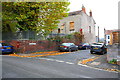
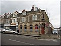
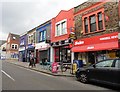
Photos of BS5 9RH


Area Information
BS5 9RH lies on Avonvale Road in the Redfield area of Easton, a part of Bristol’s urban fabric. This small postcode area is nestled within the City of Bristol, at coordinates 51.457873, -2.55516. It is a residential cluster with direct access to local amenities such as Redfield Educate Together Primary School and nearby services like Wellspring Healthy Living Centre and Bristol Futures Academy. The area is classified as urban, with proximity to a major town or city according to the 2021 census. Daily life here is shaped by its integration into Easton’s broader infrastructure, including nearby bus stops on Church Street, Day’s Road, and Beam Street. While the area is part of a highly deprived ward—ranked 1,634 out of 32,844 in the Index of Multiple Deprivation—it remains a functional residential zone with essential services within walking distance. Its compact nature means residents often rely on local transport links, such as the Lawrence Hill station, just 1 km away. For those seeking a small, service-rich postcode with urban connectivity, BS5 9RH offers a straightforward, if modest, living environment. The area’s character is defined by its proximity to educational institutions and community centres, making it a practical choice for families and individuals prioritising accessibility over expansive space.
- Area Type
- Postcode
- Area Size
- 2976 m²
- Population
- Not available
- Population Density
- Not available
BS5 9RH is a small postcode area with limited data on property ownership rates or housing types. However, its classification as part of a highly deprived ward suggests a housing stock that may include a mix of older, modest properties. The presence of schools and community centres like Cashmore Early Years Centre indicates that the area caters to families, potentially influencing the types of homes available. Given the postcode’s compact size and integration into Easton’s urban fabric, property buyers should consider the area’s proximity to transport links such as Lawrence Hill station and local bus routes. The lack of detailed property market statistics means it is difficult to assess whether the area is primarily owner-occupied or rental-dominated. However, the deprivation context implies that rental properties may be more prevalent, with affordability being a key factor for residents. For buyers, the small size of BS5 9RH means that immediate surroundings, such as nearby BS5 9TH, could offer a broader range of housing options. The area’s practicality for those prioritising accessibility over size remains a key consideration for prospective buyers.
House Prices in BS5 9RH
No properties found in this postcode.
Energy Efficiency in BS5 9RH
Amenities
Schools
| Rank | School | Type | Entry gender | Ages |
|---|
Explore more schools in this area
Go to Schools tabDemographics
BS5 9RH is part of the Barton Hill middle layer super output area, which is ranked among the most deprived in England, at 1,634 out of 32,844. This classification reflects challenges in income, employment, and housing quality, which can influence daily life and access to opportunities. The area’s urban classification, as noted in the 2021 census, indicates a population density typical of city suburbs. While specific age profiles or household types are not detailed in the data, the presence of schools such as Redfield Educate Together Primary School and early years centres suggests a concentration of families with young children. The area’s deprivation status may correlate with higher rental occupancy and a mix of modest housing stock. However, the lack of explicit demographic statistics means broader generalisations about age distribution or diversity are not supported by the available data. Residents here likely navigate a balance between local services and the broader challenges associated with living in a deprived urban area. The community’s character is shaped by its proximity to Bristol’s central amenities, though the deprivation ranking underscores systemic economic pressures that may affect quality of life.
Household Size
Accommodation Type
Tenure
Ethnic Group
Religion
Household Composition
Age
Household Deprivation
NS-SEC
Explore more demographic insights in this area
Go to Demographics tabPlanning
Planning Constraints
- Flood RiskPremium
- Ramsar Wetland SitesPremium
- Area of Outstanding Natural BeautyPremium
- Protected Nature ReservePremium
- Protected WoodlandPremium