Area Overview for BS5 9LS
Photos of BS5 9LS


Area Information
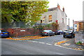
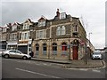
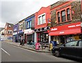
BS5 9LS is a small postcode area in Bristol, England, encompassing parts of Easton, St George, and Whitehall. Situated within the broader BS postcode region, it covers 3.29 square miles and is home to 57,433 people according to the 2021 Census. The area is defined by its proximity to motorway junctions, with the BS5 postcode district accessible to major transport routes, making it a practical choice for commuters. Daily life here blends residential living with connectivity to Bristol’s urban infrastructure. The area includes a mix of established neighbourhoods and newer developments, with local amenities such as estate agents on Church Road in nearby Redfield. Property prices for terraced homes in 2018 averaged £267,972, reflecting the area’s appeal to buyers seeking a balance between affordability and location. Residents benefit from the area’s integration into Bristol’s broader network, with access to cultural hubs, retail centres, and green spaces nearby. The compact nature of BS5 9LS means it is ideal for those prioritising convenience without sacrificing the character of a residential community.
- Area Type
- Postcode
- Area Size
- Not available
- Population
- Not available
- Population Density
- Not available
The property market in BS5 9LS is characterised by terraced homes, with an average price of £267,972 recorded in 2018. This suggests a predominance of semi-detached and terraced housing stock, typical of Bristol’s suburban and semi-urban areas. The area’s compact size means property availability is limited to a small cluster of homes, with buyers needing to consider nearby postcode districts for broader options. The presence of estate agents on Church Road in Redfield highlights local activity in the market, though specific data on rental versus ownership rates is not provided. Given the 2021 Census population of 57,433, the housing stock likely supports a mix of owner-occupied and rental properties, though the exact proportion remains unclear. Buyers should note the area’s integration with motorway access, which may influence property values and desirability for commuters.
House Prices in BS5 9LS
No properties found in this postcode.
Energy Efficiency in BS5 9LS
Amenities
Schools
| Rank | School | Type | Entry gender | Ages |
|---|
Explore more schools in this area
Go to Schools tabDemographics
BS5 9LS has a population of 57,433 people spread over 3.29 square miles, translating to a density of approximately 17,500 residents per square mile. While specific data on age distribution or household composition is not available, the area’s property market suggests a mix of home ownership and rental activity. The 2018 average price for terraced homes at £267,972 indicates a market skewed towards owner-occupation, though local estate agents on Church Road in Redfield may reflect broader rental dynamics. The presence of a postcode district served by Bristol East Delivery Office suggests a settled, long-term community. Without explicit figures on deprivation or diversity, the area’s quality of life remains contextualised by its accessibility to transport networks and proximity to Bristol’s amenities.
Household Size
Accommodation Type
Tenure
Ethnic Group
Religion
Household Composition
Age
Household Deprivation
NS-SEC
Explore more demographic insights in this area
Go to Demographics tabPlanning
Planning Constraints
- Flood RiskPremium
- Ramsar Wetland SitesPremium
- Area of Outstanding Natural BeautyPremium
- Protected Nature ReservePremium
- Protected WoodlandPremium