Area Overview for BS49 5WG
Photos of BS49 5WG


Area Information
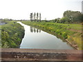
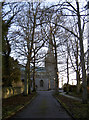
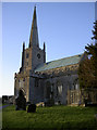
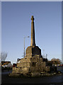
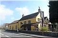
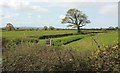
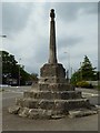
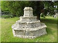
BS49 5WG is a small residential postcode in North Somerset, encompassing the village of Congresbury. With a population of 1,889 and a density of 175 people per square kilometre, it is a compact, low-density area characterised by historic architecture and rural charm. The village lies within the Mendip Hills Area of Outstanding Natural Beauty, offering residents proximity to open countryside while maintaining a village core centred on St Andrew’s Church and Broad Street. Congresbury’s conservation area, established in 1990, preserves its traditional two-storey stone cottages, Georgian buildings, and 15th-century market cross. Daily life here is shaped by its historic roots, with a mix of local amenities, nearby transport links, and a community defined by long-term residents. The area’s small size means it is both a self-contained village and part of a broader network of nearby towns, balancing seclusion with accessibility. For those seeking a blend of heritage and practicality, BS49 5WG offers a distinct identity rooted in its past but oriented toward modern living needs.
- Area Type
- Postcode
- Area Size
- Not available
- Population
- 1889
- Population Density
- 175 people/km²
The property market in BS49 5WG is predominantly owner-occupied, with 81% of homes owned by residents rather than rented. The accommodation type is largely houses, which is typical for a small village with a conservation area. This suggests a market characterised by family homes and long-term residency rather than a rental-focused environment. The limited size of the area means the housing stock is relatively uniform, with fewer high-density developments. For buyers, this implies a focus on individual properties with potential for personalisation within the conservation area’s restrictions. The lack of flats or apartments may appeal to those seeking traditional, spacious homes but could limit options for those preferring alternative housing types.
House Prices in BS49 5WG
No properties found in this postcode.
Energy Efficiency in BS49 5WG
Residents of BS49 5WG have access to a range of amenities within practical reach. Retail options include The Southern Co-operative Co, Tesco Congresbury, and Co-op Yatton, providing everyday shopping needs. The village’s historic core, including Broad Street, offers a small shopping thoroughfare with local character. Nearby railway stations connect to broader networks, while Bristol Airport is accessible for travel. A ferry service at Clevedon Pier adds leisure opportunities. The mix of retail, transport, and leisure facilities supports a convenient lifestyle, blending rural tranquillity with practical connectivity. The area’s conservation status and proximity to the Mendip Hills also offer opportunities for outdoor activities, enhancing the appeal of daily life here.
Amenities
Schools
The nearest schools to BS49 5WG include The Glebe Infant School and St Andrew’s Primary School, both of which are primary institutions. While no Ofsted ratings are provided, the presence of multiple primary schools suggests a strong local education network for younger children. The clustering of schools within the area may benefit families by reducing travel times and offering choices for early education. However, the absence of secondary schools or further education facilities in the immediate vicinity means residents may need to look beyond the postcode for comprehensive schooling. The data does not indicate the quality or performance of these schools, so prospective buyers should investigate further for detailed insights.
| Rank | School | Type | Entry gender | Ages |
|---|
Explore more schools in this area
Go to Schools tabDemographics
The population of BS49 5WG has a median age of 47, with the majority of residents aged between 30 and 64. This suggests a community skewed toward middle-aged adults, likely including families and professionals. Home ownership is high, at 81%, indicating a stable, long-term resident base. The primary accommodation type is houses, reflecting a preference for single-family homes over flats. The predominant ethnic group is White, with no specific data on other demographics. The age profile and ownership figures imply a mature, settled population, which may influence local services and amenities. The absence of detailed diversity statistics means the community’s full composition remains less defined, but the data underscores a focus on traditional, owner-occupied housing.
Household Size
Accommodation Type
Tenure
Ethnic Group
Religion
Household Composition
Age
Household Deprivation
NS-SEC
Explore more demographic insights in this area
Go to Demographics tabPlanning
Planning Constraints
- Flood RiskPremium
- Ramsar Wetland SitesPremium
- Area of Outstanding Natural BeautyPremium
- Protected Nature ReservePremium
- Protected WoodlandPremium