Area Overview for BS49 4WH
Photos of BS49 4WH

Area Information
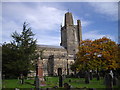
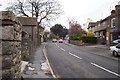
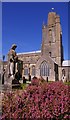
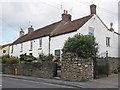
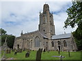
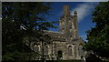
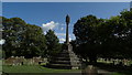
BS49 4WH is a small residential postcode in North Somerset, encompassing the village of Yatton. With a population of 1,500, it is a compact area where historic and modern elements coexist. Yatton sits on the North Somerset Levels, a landscape of low-lying land and watercourses, historically shaped by Iron Age and Roman activity. The village has evolved from a medieval settlement into a commuter hub for Bristol, thanks to the Bristol & Exeter Railway, engineered by Isambard Kingdom Brunel. Today, the area blends traditional housing with modern amenities. Residents benefit from proximity to rail links, retail outlets, and nearby natural features like Cadbury Hill, which holds Iron Age and Roman archaeological significance. The community is predominantly middle-aged, with 84% owning their homes, reflecting a stable, long-term demographic. Daily life here is characterised by a quiet, village atmosphere, with easy access to nearby towns and transport networks. For buyers, BS49 4WH offers a blend of historical charm, practical connectivity, and a low-crime environment, making it appealing for those seeking a settled lifestyle near Bristol.
- Area Type
- Postcode
- Area Size
- Not available
- Population
- 1500
- Population Density
- 3015 people/km²
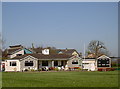
BS49 4WH is predominantly an owner-occupied area, with 84% of homes owned by their residents. The accommodation type is largely houses, reflecting a residential cluster with limited high-density development. This suggests a market characterised by family homes and long-term investment rather than rental properties. The small size of the postcode means the housing stock is limited, with fewer new builds or speculative developments. For buyers, this implies a competitive market where properties are likely to be well-maintained and sought after by those prioritising stability and security. The absence of flats or apartments indicates a focus on traditional, spacious housing, which may appeal to families or those preferring larger living spaces. Proximity to rail links and nearby amenities like Bristol Airport further enhances the area’s appeal for commuters and those seeking a balance between rural tranquillity and urban accessibility.
House Prices in BS49 4WH
No properties found in this postcode.
Energy Efficiency in BS49 4WH
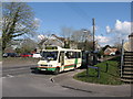
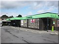
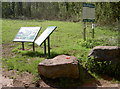
Living in BS49 4WH offers access to a range of amenities within practical reach. Retail options include five shops, such as Co-op Yatton and Tesco Congresbury, providing everyday necessities. The area’s rail network connects residents to nearby towns, with stations like Yatton Railway Station and Nailsea & Backwell Railway Station offering links to Bristol and beyond. Proximity to Bristol Airport and Clevedon Pier adds to the area’s appeal, with the latter offering leisure opportunities like boat trips. While the data does not mention parks or recreational spaces, the historical landscape of the North Somerset Levels suggests natural areas for walking or cycling. The village’s character is defined by its mix of historic sites, like Cadbury Hill, and practical amenities, creating a balance between heritage and modern convenience. Residents can enjoy a quiet village life while benefiting from nearby urban facilities, making it suitable for those valuing both tranquillity and accessibility.
Amenities
Schools
The area is served by two primary schools: Yatton Voluntary Controlled Infant School, a traditional primary school, and Yatton Infant School, an academy with a good Ofsted rating. Both institutions cater to younger children, offering parents a choice between a state-funded model and an academy system. The presence of a school with a good rating suggests high educational standards and effective resource management. Families in BS49 4WH benefit from a mix of school types, ensuring options for different educational philosophies. The proximity of these schools to residential areas means children can attend without long commutes, supporting a family-friendly environment. While no secondary schools are listed, the nearby town of Congresbury likely provides further educational options. The quality of local schooling is a key factor for families prioritising education in their housing decisions.
| Rank | School | Type | Entry gender | Ages |
|---|
Explore more schools in this area
Go to Schools tabDemographics
The population of BS49 4WH is 1,500, with a median age of 47. The majority of residents fall within the 30–64 age range, indicating a mature, established community. Home ownership is high at 84%, with houses being the predominant type of accommodation. The predominant ethnic group is White, reflecting the area’s historical and cultural continuity. This demographic profile suggests a stable, low-turnover environment where families and long-term residents predominate. The age range implies a population with strong ties to local institutions, such as schools and community networks. With no specific data on deprivation, the area’s characteristics—such as high home ownership and low crime—suggest a relatively affluent, secure living environment. The absence of significant age groups under 25 or over 65 means the community is neither heavily focused on education nor retirement, balancing practicality with a settled, middle-aged core.
Household Size
Accommodation Type
Tenure
Ethnic Group
Religion
Household Composition
Age
Household Deprivation
NS-SEC
Explore more demographic insights in this area
Go to Demographics tabPlanning
Planning Constraints
- Flood RiskPremium
- Ramsar Wetland SitesPremium
- Area of Outstanding Natural BeautyPremium
- Protected Nature ReservePremium
- Protected WoodlandPremium