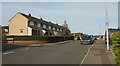
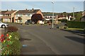
Area Overview for BS41 9UZ
Photos of BS41 9UZ


Area Information
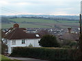
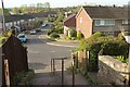
BS41 9UZ is a small residential postcode in England, home to 2,673 people in a compact area with a population density of 1,435 per square kilometre. This cluster of homes sits near Bristol, within reach of historical landmarks and natural features. The area’s character is shaped by its proximity to Long Ashton, a village with roots in Saxon times and recorded in the Domesday Book. Residents benefit from a mix of modern amenities and traditional charm, with access to nearby villages, rail links, and the River Avon. Daily life here balances suburban tranquillity with practical connectivity, supported by a low crime rate and minimal environmental risks. The community is predominantly middle-aged, with a strong presence of owner-occupied houses. Living in BS41 9UZ offers a blend of convenience and historical context, ideal for those seeking a settled, low-maintenance lifestyle near major transport routes and local services.
- Area Type
- Postcode
- Area Size
- Not available
- Population
- 2673
- Population Density
- 1435 people/km²
BS41 9UZ is a largely owner-occupied area, with 76% of homes owned by residents rather than rented. The accommodation type is predominantly houses, which is typical for smaller, residential postcodes. This suggests a market focused on family homes and long-term residency rather than short-term rental properties. The density of 1,435 people per square kilometre indicates a compact, possibly semi-rural layout with limited scope for new developments. For buyers, this means a limited selection of properties, but with a strong emphasis on stability and community. The prevalence of houses may appeal to those seeking space and privacy, though the small size of the area means competition for available homes. Proximity to transport links and amenities further enhances the area’s attractiveness for owner-occupiers.
House Prices in BS41 9UZ
No properties found in this postcode.
Energy Efficiency in BS41 9UZ
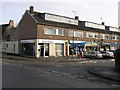
Residents of BS41 9UZ have access to a range of amenities within practical reach. Retail options include Co-op Long, Sainsburys Winterstoke, and Iceland South Bristol Retail, providing daily shopping needs. Ferries at Nova Scotia, Cottage, and Pumphouse landings offer scenic travel routes, while rail stations like Parson Street and Clifton Down connect to Bristol’s broader network. The proximity to Bristol Airport ensures easy travel for regional and international trips. These amenities contribute to a lifestyle that balances convenience with access to natural and urban environments. The mix of retail, transport, and leisure options supports both practical living and recreational activities, enhancing the area’s appeal for families and commuters alike.
Amenities
Schools
The nearest school to BS41 9UZ is Birdwell Primary School, a primary school serving the local community. With two entries listed for this institution, it is likely the sole primary school in the immediate vicinity. While no Ofsted ratings are provided, the presence of a primary school suggests that families with young children have access to local education. The lack of secondary schools nearby may require residents to travel to adjacent areas for further education. This school’s availability supports the area’s appeal to families, though parents should verify current performance metrics independently. The absence of additional schools indicates a need for broader educational options beyond primary level.
| Rank | School | Type | Entry gender | Ages |
|---|
Explore more schools in this area
Go to Schools tabDemographics
The population of BS41 9UZ has a median age of 47, with the majority of residents aged 30–64. This suggests a community of established professionals and families, reflecting a mature demographic profile. Home ownership is high, at 76%, indicating a stable, long-term resident base. The area is predominantly composed of houses rather than flats, aligning with the preference of older households. The predominant ethnic group is White, though specific data on diversity is not provided. The age distribution and ownership rates imply a low turnover of properties, contributing to a cohesive neighbourhood. With no data on deprivation levels, it is reasonable to infer that the area’s stability and infrastructure support a decent quality of life, though further local surveys would clarify socioeconomic nuances.
Household Size
Accommodation Type
Tenure
Ethnic Group
Religion
Household Composition
Age
Household Deprivation
NS-SEC
Explore more demographic insights in this area
Go to Demographics tabPlanning
Planning Constraints
- Flood RiskPremium
- Ramsar Wetland SitesPremium
- Area of Outstanding Natural BeautyPremium
- Protected Nature ReservePremium
- Protected WoodlandPremium