Area Overview for BS41 9EL
Photos of BS41 9EL
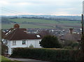
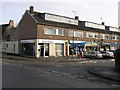
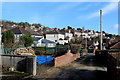
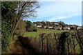

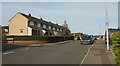
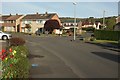
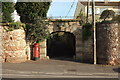
54 photos from this area
Area Information
Key information about the BS41 9EL including its size, population, and administrative classification.
- Area Type
- Postcode
- Area Size
- 1313 m²
- Population
- 1809
- Population Density
- 220 people/km²
House Prices in BS41 9EL
4
Properties
£244,167
Average Sold Price
£195,000
Lowest Price
£300,000
Highest Price
Showing 4 properties
| Address | Type | Beds | Baths | Last Sale Price | Last Sale Date | |
|---|---|---|---|---|---|---|
| 21 Short Lane, Long Ashton, BS41 9EL | Cottage | 2 | 1 | £300,000 | Apr 2023 | |
| 17 Short Lane, Long Ashton, BS41 9EL | house | 3 | - | £237,500 | Dec 2013 | |
| 19 Short Lane, Long Ashton, BS41 9EL | house | - | - | £195,000 | Jun 2013 | |
| 15 Short Lane, Long Ashton, BS41 9EL | Terraced | 2 | - | - | - |
Energy Efficiency in BS41 9EL
Amenities
Schools
| Rank | School | Type | Entry gender | Ages |
|---|
Explore more schools in this area
Go to Schools tabDemographics
Household Size
Two person
most common
Accommodation Type
Houses
most common
Tenure
91
majority
Ethnic Group
White
most common
Religion
N/A
most common
Household Composition
N/A
most common
Age
47
median
Adults (30-64 years)
most common
Household Deprivation
N/A
with no deprivation
NS-SEC
55
in Lower managerial occupations
Explore more demographic insights in this area
Go to Demographics tabPlanning
Planning Constraints
- Flood RiskPremium
- Ramsar Wetland SitesPremium
- Area of Outstanding Natural BeautyPremium
- Protected Nature ReservePremium
- Protected WoodlandPremium