Area Overview for BS41 9AY
Photos of BS41 9AY
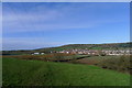
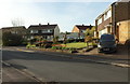
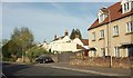
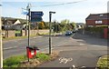
39 photos from this area
Area Information
Key information about the BS41 9AY including its size, population, and administrative classification.
- Area Type
- Postcode
- Area Size
- 4854 m²
- Population
- 2673
- Population Density
- 1435 people/km²
House Prices in BS41 9AY
20
Properties
£242,725
Average Sold Price
£155,000
Lowest Price
£400,000
Highest Price
Showing 20 properties
| Address | Type | Beds | Baths | Last Sale Price | Last Sale Date | |
|---|---|---|---|---|---|---|
| 16 Elmhurst Gardens, Long Ashton, BS41 9AY | Terraced | 2 | 1 | £313,250 | Aug 2024 | |
| 14 Elmhurst Gardens, Long Ashton, BS41 9AY | Terraced | 2 | 1 | £350,000 | Jun 2023 | |
| 2 Elmhurst Gardens, Long Ashton, BS41 9AY | Semi-detached | 4 | 2 | £400,000 | Jun 2021 | |
| 9 Elmhurst Gardens, Long Ashton, BS41 9AY | Terraced | 3 | 1 | £294,000 | Feb 2020 | |
| 10 Elmhurst Gardens, Long Ashton, BS41 9AY | Terraced | 2 | 1 | £273,000 | Jun 2018 | |
| 17 Elmhurst Gardens, Long Ashton, BS41 9AY | house | 2 | 1 | £249,950 | Jun 2016 | |
| 7 Elmhurst Gardens, Long Ashton, BS41 9AY | house | - | - | £174,500 | Jan 2012 | |
| 19 Elmhurst Gardens, Long Ashton, BS41 9AY | Terraced | 3 | 1 | £155,000 | Aug 2009 | |
| 20 Elmhurst Gardens, Long Ashton, BS41 9AY | Terraced | - | - | £170,000 | May 2008 | |
| 15 Elmhurst Gardens, Long Ashton, BS41 9AY | Terraced | 3 | 1 | £195,000 | Aug 2007 |
Page 1 of 2
Energy Efficiency in BS41 9AY
Amenities
Schools
| Rank | School | Type | Entry gender | Ages |
|---|
Explore more schools in this area
Go to Schools tabDemographics
Household Size
Family (3-5 people)
most common
Accommodation Type
Houses
most common
Tenure
76
majority
Ethnic Group
White
most common
Religion
N/A
most common
Household Composition
N/A
most common
Age
47
median
Adults (30-64 years)
most common
Household Deprivation
N/A
with no deprivation
NS-SEC
51
in Lower managerial occupations
Explore more demographic insights in this area
Go to Demographics tabPlanning
Planning Constraints
- Flood RiskPremium
- Ramsar Wetland SitesPremium
- Area of Outstanding Natural BeautyPremium
- Protected Nature ReservePremium
- Protected WoodlandPremium