Area Overview for BS41 9AF
Photos of BS41 9AF


Area Information
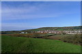
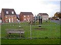
BS41 9AF is a small, tightly knit residential area nestled in the outskirts of Bristol, England. With a population of 2,673 and a population density of 1,435 people per square kilometre, it reflects a compact, community-focused living environment. The area is part of Long Ashton, a village with roots in Saxon times, noted for its historical significance and proximity to natural features like the River Avon and Ashton Brook. Residents benefit from a blend of traditional and modern amenities, with the area’s layout stretching along main roads and bordered by ancient parishes. Daily life here is shaped by its rural character, with easy access to Bristol’s urban offerings. The presence of landmarks such as the parish church of All Saints and the historic Ashton Court estate adds a layer of heritage to the area. For those seeking a balance between tranquillity and connectivity, BS41 9AF offers a compact, well-served environment with a distinct local identity.
- Area Type
- Postcode
- Area Size
- Not available
- Population
- 2673
- Population Density
- 1435 people/km²
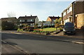
The property market in BS41 9AF is largely defined by owner-occupation, with 76% of homes owned by residents rather than rented. The area’s accommodation type is predominantly houses, which suggests a focus on single-family dwellings rather than apartments or flats. This configuration is typical of suburban or semi-rural settings, where larger properties are more common. Given the small size of the postcode area, the housing stock is likely limited in volume, making it a niche market for buyers seeking spacious, private homes. The high home ownership rate also implies a stable market with lower turnover, which can be advantageous for long-term investment. However, the limited availability of properties may mean that buyers need to consider nearby areas for additional options.
House Prices in BS41 9AF
No properties found in this postcode.
Energy Efficiency in BS41 9AF
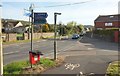
The lifestyle in BS41 9AF is enriched by a range of nearby amenities within practical reach. Retail options include supermarkets such as Co-op Long, Sainsburys Winterstoke, and Morrisons Daily Bristol, ensuring everyday shopping needs are met. The area’s proximity to rail stations and ferry landings enhances mobility, while the presence of two airports nearby—Bristol Airport—offers convenience for travel. For leisure, the historical and natural landmarks of Long Ashton, including the parish church of All Saints and Ashton Court, provide cultural and recreational opportunities. The combination of retail, transport, and historical sites creates a balanced lifestyle, blending practicality with local character.
Amenities
Schools
The nearest schools to BS41 9AF include Birdwell Primary School, which serves the local community. While the data does not provide Ofsted ratings, the presence of a primary school indicates that families with young children have access to local education. The absence of secondary schools in the immediate vicinity suggests that residents may need to travel to nearby towns for higher education. The availability of a primary school supports the area’s appeal to families, though the broader educational landscape would require further exploration beyond the immediate postcode.
| Rank | School | Type | Entry gender | Ages |
|---|
Explore more schools in this area
Go to Schools tabDemographics
The community in BS41 9AF is predominantly composed of adults aged 30–64, with a median age of 47. This suggests a mature, stable population, likely with established careers and families. Home ownership is high at 76%, indicating a strong presence of long-term residents and a lower proportion of rental properties. The area is characterised by houses rather than flats, reflecting a preference for private, family-oriented living spaces. The predominant ethnic group is White, though specific diversity metrics are not detailed in the data. The age profile and ownership statistics point to a community that values security and continuity, with fewer transient populations. This demographic structure may influence local services and amenities, which are tailored to the needs of a middle-aged, homeownership-driven populace.
Household Size
Accommodation Type
Tenure
Ethnic Group
Religion
Household Composition
Age
Household Deprivation
NS-SEC
Explore more demographic insights in this area
Go to Demographics tabPlanning
Planning Constraints
- Flood RiskPremium
- Ramsar Wetland SitesPremium
- Area of Outstanding Natural BeautyPremium
- Protected Nature ReservePremium
- Protected WoodlandPremium