Area Overview for BS39 5DS
Photos of BS39 5DS
Area Information
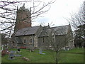
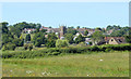
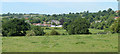
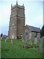
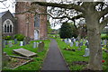
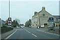
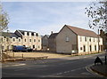
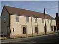
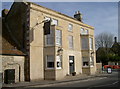
BS39 5DS is a small, rural postcode area in Somerset, encompassing the villages of Temple Cloud and Cameley on the northern slopes of the Mendip Hills. With a population of 1,517 and a density of 230 people per square kilometre, it retains a quiet, countryside character. The area’s history stretches back to Anglo-Saxon times, with its name derived from “Camelie” (curved river meadows) and “Cloud” (possibly linked to the Knights Templar). Today, it balances historical charm with modern convenience, sitting on the A37 road 10 miles south of Bristol. The parish includes St James Church, a 13th-century building with medieval wall paintings, and the Temple Inn pub, a listed venue. Community facilities like Cameley Playing Fields and Temple Cloud Village Hall reflect its low deprivation status (ranked 25,387 out of 32,482 in 2004), suggesting affluence and stability. Daily life here is defined by rural tranquillity, with easy access to nearby towns like Midsomer Norton and Clutton station. The area’s mix of historical sites, green spaces, and community hubs makes it appealing to those seeking a peaceful, well-connected lifestyle.
- Area Type
- Postcode
- Area Size
- Not available
- Population
- 1517
- Population Density
- 230 people/km²
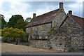
BS39 5DS is predominantly an owner-occupied area, with 76% of homes owned by residents rather than rented. The accommodation type is primarily houses, reflecting the rural, low-density nature of the postcode. This contrasts with urban areas where flats and apartments dominate, suggesting a market focused on single-family homes. The small size of the area means housing stock is limited, which can drive demand for properties in the immediate vicinity. Buyers should consider the scarcity of options, as the cluster of homes is likely to be older, with historical features such as listed buildings and traditional architecture. The high home ownership rate indicates a stable market, but the limited number of properties may mean fewer choices for buyers. Those seeking a countryside lifestyle with a sense of community may find this area appealing, though competition for available homes could be intense.
House Prices in BS39 5DS
No properties found in this postcode.
Energy Efficiency in BS39 5DS
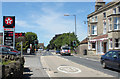
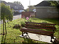
Living in BS39 5DS offers access to a range of local amenities within practical reach. Retail options include Spar, The Radstock Co-operative Society Co, and Budgens Farrington, providing essential shopping and services. The area’s rural character is complemented by community spaces like Cameley Playing Fields and Temple Cloud Village Hall, which host events and activities. The nearby villages of Temple Cloud and Cameley retain a quiet, countryside feel, with historical sites such as St James Church and the Temple Inn pub adding to the area’s charm. Residents can enjoy outdoor leisure in the Mendip Hills, with the Cam Brook and surrounding green spaces offering opportunities for walking and recreation. The combination of local shops, community facilities, and natural beauty supports a lifestyle that balances convenience with tranquillity, ideal for those seeking a slower pace of life.
Amenities
Schools
The nearest schools to BS39 5DS are Cameley CofE VC Primary School and Cameley CEVC Primary School, both of which are primary schools. While no Ofsted ratings are provided in the data, the presence of two primary schools suggests a focus on early education for local families. The duplication of school names (Cameley CofE VC and Cameley CEVC) may indicate separate institutions or different branches of the same school. For parents, this proximity to primary education is a key consideration, ensuring children can attend local schools without long commutes. The absence of secondary schools in the data implies that families may need to travel to nearby towns for secondary education, such as Midsomer Norton or Bath. The availability of primary schools supports the area’s appeal for families seeking a balanced lifestyle with access to essential services.
| Rank | School | Type | Entry gender | Ages |
|---|
Explore more schools in this area
Go to Schools tabDemographics
The population of BS39 5DS is 1,517, with a median age of 47 and the majority (30-64 years) falling into the adult age range. Home ownership is high at 76%, with houses being the predominant accommodation type. The predominant ethnic group is White, reflecting the area’s historical and cultural continuity. The low deprivation ranking (25,387 out of 32,482 in 2004) indicates a relatively affluent community, which often correlates with better access to services and lower crime rates. This demographic profile suggests a stable, mature population likely invested in long-term residency. The age distribution implies a mix of established households and retirees, with fewer young families compared to urban areas. The high home ownership rate points to a community where property is seen as a long-term asset, reinforcing the area’s appeal for those prioritising security and permanence.
Household Size
Accommodation Type
Tenure
Ethnic Group
Religion
Household Composition
Age
Household Deprivation
NS-SEC
Explore more demographic insights in this area
Go to Demographics tabPlanning
Planning Constraints
- Flood RiskPremium
- Ramsar Wetland SitesPremium
- Area of Outstanding Natural BeautyPremium
- Protected Nature ReservePremium
- Protected WoodlandPremium