Area Overview for BS39 4YY
Photos of BS39 4YY
Area Information
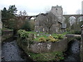
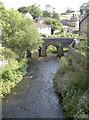
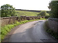
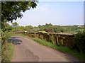
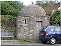
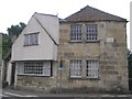
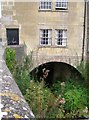
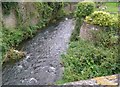
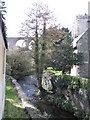
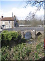
BS39 4YY lies in a small residential cluster within the Chew Valley, part of Bath and North East Somerset. The area’s population of 1,201 is spread across 1723 acres, with a density of 172 people per square kilometre, reflecting its rural yet compact character. Historically, the parish of Publow, which includes Pensford and surrounding hamlets, has been shaped by its proximity to the River Chew and ancient land disputes. Today, the area retains a quiet, village-like atmosphere, with the Church of All Saints—a 14th-century Grade I listed building—standing as a central landmark. Daily life here is defined by proximity to nature and local heritage, with the medieval bridge over the River Chew, rebuilt in the late 18th century, serving as a tangible link to the past. The area’s small size means residents often know their neighbours, and community ties are strong. For those seeking a peaceful, low-density living environment with historical depth, BS39 4YY offers a blend of tranquillity and accessible amenities.
- Area Type
- Postcode
- Area Size
- Not available
- Population
- 1201
- Population Density
- 172 people/km²
BS39 4YY is predominantly an owner-occupied area, with 77% of homes owned by residents rather than rented. The accommodation type is primarily houses, which is typical of rural or semi-rural postcodes where larger properties are more common. This suggests a market skewed towards families or individuals seeking spacious, private living environments. The small population and compact size of the area mean the housing stock is limited, with fewer options for buyers compared to larger urban centres. However, the high home ownership rate indicates strong local demand and potentially stable property values. For those considering the area, the focus on houses rather than flats or apartments means buyers should expect larger plots and more traditional architectural styles. The proximity to nearby towns like Keynsham and Bath may also influence property prices, offering a balance between rural charm and access to urban services.
House Prices in BS39 4YY
No properties found in this postcode.
Energy Efficiency in BS39 4YY
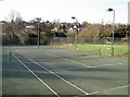
Residents of BS39 4YY have access to a range of local amenities within practical reach. Retail options include The Radstock Co-operative Society Co, Co-op Whitchurch, and Co-op Stockwood, providing essential groceries and services. The area’s proximity to railway stations and ferry terminals enhances mobility, allowing easy access to nearby towns and cities. For leisure, the River Chew and surrounding green spaces offer opportunities for walking, cycling, and outdoor activities. The historic Church of All Saints and the medieval bridge add cultural and architectural interest. While the area’s small size means limited dining or entertainment venues, its rural setting compensates with tranquillity and natural beauty. The mix of retail, transport, and historical sites creates a lifestyle that balances convenience with a connection to the region’s heritage.
Amenities
Schools
The nearest school to BS39 4YY is Pensford Primary School, a primary education institution serving the local community. The presence of a single primary school suggests that families in the area may need to travel to nearby towns for secondary education, though the school itself provides a foundation for early learning. As a primary school, it likely caters to children aged 4–11, with a focus on core subjects and localised community engagement. The absence of secondary schools in the immediate vicinity means parents should consider commuting options for older children. For families prioritising proximity to educational facilities, Pensford Primary School offers a practical starting point, though the lack of a comprehensive school network may be a factor in long-term planning.
| Rank | School | Type | Entry gender | Ages |
|---|---|---|---|---|
| 1 | Pensford Primary School | primary | N/A | N/A |
| 2 | Pensford Primary School | primary | N/A | N/A |
Explore more schools in this area
Go to Schools tabDemographics
The population of BS39 4YY has a median age of 47, with the majority of residents falling within the 30-64 age range. This suggests a mature, stable community with a focus on established households. Home ownership is high at 77%, indicating a predominance of long-term residents rather than transient renters. The accommodation type is primarily houses, reflecting a rural or semi-rural setting where larger properties are more common. The predominant ethnic group is White, aligning with broader demographic trends in the region. While no specific deprivation data is provided, the high home ownership and low population density imply a relatively affluent and settled community. The absence of significant diversity metrics means the area’s cultural composition is likely homogeneous, though this does not necessarily reflect a lack of inclusivity. For buyers, the demographic profile suggests a neighbourhood prioritising stability, family-oriented living, and proximity to natural surroundings.
Household Size
Accommodation Type
Tenure
Ethnic Group
Religion
Household Composition
Age
Household Deprivation
NS-SEC
Explore more demographic insights in this area
Go to Demographics tabPlanning
Planning Constraints
- Flood RiskPremium
- Ramsar Wetland SitesPremium
- Area of Outstanding Natural BeautyPremium
- Protected Nature ReservePremium
- Protected WoodlandPremium
- Crime RiskPremium