Area Overview for BS36 2XG
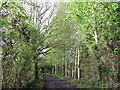
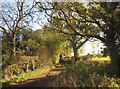
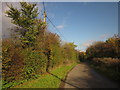
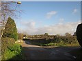
Photos of BS36 2XG
Area Information
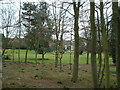
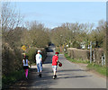
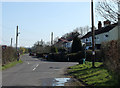
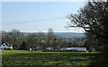
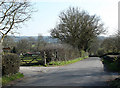
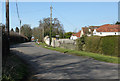
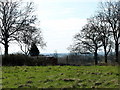
Living in BS36 2XG means residing in a small, rural cluster within the civil parish of Westerleigh and Coalpit Heath, South Gloucestershire. With a population of 1,939 and a density of 133 people per square kilometre, this area balances quiet countryside with accessible amenities. Nestled just 1 mile south of Yate and 10 miles northeast of Bristol, it sits near the Frome Valley Walkway and features historic landmarks like St James the Great Church, built in 1304. The village of Westerleigh and smaller hamlets like Henfield and Nibley create a close-knit community. Daily life here is shaped by its history of coal mining, which ceased in 1949, and its current mix of rural tranquillity and practical transport links. Residents benefit from proximity to the M4 motorway and multiple rail stations, while the area’s low population density ensures a peaceful, unhurried pace. This is a place for those seeking a blend of heritage, natural beauty, and modern convenience without the bustle of larger cities.
- Area Type
- Postcode
- Area Size
- Not available
- Population
- 1939
- Population Density
- 133 people/km²
The property market in BS36 2XG is characterised by high home ownership (81%) and a predominance of houses. This indicates a largely owner-occupied area, with limited rental activity. The focus on houses rather than flats or apartments suggests a demand for family-friendly, spacious homes, typical of rural and semi-rural settings. Given the small population and clustered layout, the housing stock is likely limited, making the area competitive for buyers. The proximity to Yate and Bristol, combined with transport links like rail stations and the M4, may attract buyers seeking a balance between countryside living and urban accessibility. However, the small size of the area means that property options are constrained, and buyers should consider nearby suburbs for more choices. The market here is likely stable, with properties retaining value due to the area’s low crime rates and historical appeal.
House Prices in BS36 2XG
No properties found in this postcode.
Energy Efficiency in BS36 2XG
Residents of BS36 2XG have access to a range of amenities within practical reach. Retail options include Sainsburys, Budgens Mangotsfield, and Morrisons Daily, ensuring everyday shopping needs are met. The area’s rail network connects to Yate, Bristol Parkway, and Filton Abbey Wood, while metro stations at Oldland and Bitton provide further links. For leisure, Bitterwell Lake at Henfield offers recreational space, and Coalpit Heath Cricket Club at Ram Hill caters to sports enthusiasts. A 27-hole golf course at Kendleshire adds to the area’s appeal. The proximity to Bristol Filton Airport and Netham Lock Ferry Terminal enhances mobility. These amenities combine to create a lifestyle that balances convenience with rural charm, offering both practicality and opportunities for outdoor activities.
Amenities
Schools
Near BS36 2XG are two notable schools: Vinney Green Secure Unit, which is classified as an 'other' institution, and Immanuel Christian School, an independent school with a Good Ofsted rating. The presence of both a secure unit and an independent school reflects a mix of educational options, though no state-funded schools are listed. Families seeking independent education may find Immanuel Christian School appealing, given its positive rating, while the secure unit suggests a focus on specialised or alternative education. However, the lack of state schools could be a consideration for those prioritising public education. Parents should verify whether the schools’ catchment areas include BS36 2XG and assess their specific needs, such as curriculum type or proximity to home. The absence of detailed data on school performance beyond Ofsted ratings means further research into academic outcomes and facilities would be prudent.
| Rank | School | Type | Entry gender | Ages |
|---|
Explore more schools in this area
Go to Schools tabDemographics
The community in BS36 2XG is predominantly composed of adults aged 30–64, with a median age of 47. This suggests a mature, stable population, likely with established careers and families. Home ownership is high at 81%, indicating a strong sense of long-term commitment to the area. The accommodation type is primarily houses, reflecting a residential character distinct from high-density housing. The predominant ethnic group is White, aligning with broader trends in rural South Gloucestershire. The age profile and ownership rates imply a community focused on stability rather than transient living. While no specific deprivation data is provided, the high home ownership and low population density suggest a relatively affluent, low-pressure environment. This demographic profile positions BS36 2XG as a place where families and professionals value quiet living without sacrificing access to essential services.
Household Size
Accommodation Type
Tenure
Ethnic Group
Religion
Household Composition
Age
Household Deprivation
NS-SEC
Explore more demographic insights in this area
Go to Demographics tabPlanning
Planning Constraints
- Flood RiskPremium
- Ramsar Wetland SitesPremium
- Area of Outstanding Natural BeautyPremium
- Protected Nature ReservePremium
- Protected WoodlandPremium