Area Overview for BS36 2LH
Photos of BS36 2LH
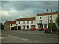


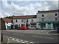
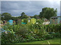
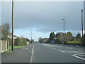
23 photos from this area
Area Information
Key information about the BS36 2LH including its size, population, and administrative classification.
- Area Type
- Postcode
- Area Size
- 1.1 hectares
- Population
- Not available
- Population Density
- Not available
House Prices in BS36 2LH
29
Properties
£276,594
Average Sold Price
£77,500
Lowest Price
£557,000
Highest Price
Showing 29 properties
| Address | Type | Beds | Baths | Last Sale Price | Last Sale Date | |
|---|---|---|---|---|---|---|
| 74 Woodend Road, Coalpit Heath, BS36 2LH | Detached | 4 | 2 | £440,000 | Feb 2021 | |
| 62 Woodend Road, Coalpit Heath, BS36 2LH | house | - | - | £357,500 | Oct 2020 | |
| 48 Woodend Road, Coalpit Heath, BS36 2LH | house | - | - | £338,750 | Feb 2017 | |
| 60 Woodend Road, Coalpit Heath, BS36 2LH | Detached | 4 | 2 | £557,000 | Apr 2015 | |
| 51 Woodend Road, Coalpit Heath, BS36 2LH | Terraced | - | - | £225,000 | Jun 2004 | |
| 52 Woodend Road, Coalpit Heath, BS36 2LH | Semi-detached | - | - | £77,500 | Jan 1997 | |
| 44 Woodend Road, Coalpit Heath, BS36 2LH | house | 5 | - | £120,000 | Jul 1996 | |
| 41 Woodend Road, Coalpit Heath, BS36 2LH | Detached | - | - | £97,000 | Feb 1995 | |
| 55 Woodend Road, Coalpit Heath, BS36 2LH | Detached | 3 | 1 | - | - | |
| 47 Woodend Road, Coalpit Heath, BS36 2LH | Semi-detached | 3 | 1 | - | - |
Page 1 of 3
Energy Efficiency in BS36 2LH
Amenities
Schools
| Rank | School | Type | Entry gender | Ages |
|---|
Explore more schools in this area
Go to Schools tabDemographics
Household Size
Two person
most common
Accommodation Type
Houses
most common
Tenure
89
majority
Ethnic Group
White
most common
Religion
N/A
most common
Household Composition
N/A
most common
Age
47
median
Adults (30-64 years)
most common
Household Deprivation
N/A
with no deprivation
NS-SEC
45
in Lower managerial occupations
Explore more demographic insights in this area
Go to Demographics tabPlanning
Planning Constraints
- Flood RiskPremium
- Ramsar Wetland SitesPremium
- Area of Outstanding Natural BeautyPremium
- Protected Nature ReservePremium
- Protected WoodlandPremium