Area Overview for BS35 1DE
Photos of BS35 1DE

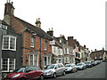
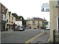
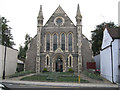

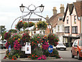
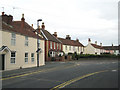
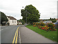
100 photos from this area
Area Information
Key information about the BS35 1DE including its size, population, and administrative classification.
- Area Type
- Postcode
- Area Size
- 2831 m²
- Population
- 1678
- Population Density
- 692 people/km²
House Prices in BS35 1DE
16
Properties
£149,702
Average Sold Price
£71,000
Lowest Price
£200,000
Highest Price
Showing 16 properties
| Address | Type | Beds | Baths | Last Sale Price | Last Sale Date | |
|---|---|---|---|---|---|---|
| 11, Gloucester Terrace, Gloucester Road, Thornbury, BS35 1DE | Flat | 2 | - | £180,000 | Feb 2023 | |
| 9, Gloucester Terrace, Gloucester Road, Thornbury, BS35 1DE | Flat | - | - | £200,000 | Sep 2022 | |
| 3, Gloucester Terrace, Gloucester Road, Thornbury, BS35 1DE | Flat | - | - | £190,000 | Jun 2022 | |
| 8, Gloucester Terrace, Gloucester Road, Thornbury, BS35 1DE | Flat | 2 | 1 | £180,000 | Feb 2021 | |
| 16, Gloucester Terrace, Gloucester Road, Thornbury, BS35 1DE | Flat | - | - | £178,000 | Jan 2020 | |
| 6, Gloucester Terrace, Gloucester Road, Thornbury, BS35 1DE | Flat | - | - | £166,000 | Dec 2017 | |
| 10, Gloucester Terrace, Gloucester Road, Thornbury, BS35 1DE | Flat | 2 | 1 | £156,500 | Mar 2015 | |
| 13, Gloucester Terrace, Gloucester Road, Thornbury, BS35 1DE | Flat | - | - | £74,375 | Jan 2015 | |
| 5, Gloucester Terrace, Gloucester Road, Thornbury, BS35 1DE | Flat | - | - | £127,500 | Jan 2014 | |
| 1, Gloucester Terrace, Gloucester Road, Thornbury, BS35 1DE | Flat | 2 | 2 | £148,000 | May 2010 |
Page 1 of 2
Energy Efficiency in BS35 1DE
Amenities
Schools
| Rank | School | Type | Entry gender | Ages |
|---|
Explore more schools in this area
Go to Schools tabDemographics
Household Size
Two person
most common
Accommodation Type
Houses
most common
Tenure
68
majority
Ethnic Group
White
most common
Religion
N/A
most common
Household Composition
N/A
most common
Age
47
median
Adults (30-64 years)
most common
Household Deprivation
N/A
with no deprivation
NS-SEC
41
in Lower managerial occupations
Explore more demographic insights in this area
Go to Demographics tabPlanning
Planning Constraints
- Flood RiskPremium
- Ramsar Wetland SitesPremium
- Area of Outstanding Natural BeautyPremium
- Protected Nature ReservePremium
- Protected WoodlandPremium