Area Overview for BS31 2WG
Photos of BS31 2WG


Area Information
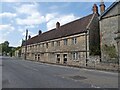
BS31 2WG lies in Keynsham, a civil parish in Somerset, where the River Chew meets the River Avon, just 7¼ miles west-north-west of Bath. This small postcode area, home to 2,466 residents, has a population density of 598 people per square kilometre, reflecting its compact residential cluster. Keynsham’s history stretches back to the Domesday Book of 1086, when it was recorded as “Cainesham.” The area once thrived as a medieval market town, shaped by Keynsham Abbey, founded in 1170 by the Victorine congregation. Today, it remains a quiet, low-density suburb within the Bath and North East Somerset unitary authority. The parish’s charm lies in its blend of historical heritage and modern convenience, with Grade I and II* listed buildings coexisting alongside contemporary amenities. Residents benefit from proximity to Bath’s cultural offerings, while the area’s modest size fosters a close-knit community feel. The postcode’s small footprint means it is ideal for those seeking a peaceful, semi-rural lifestyle without sacrificing access to essential services.
- Area Type
- Postcode
- Area Size
- Not available
- Population
- 2466
- Population Density
- 598 people/km²
BS31 2WG is predominantly an owner-occupied area, with 77% of homes owned by residents rather than rented. The accommodation type is largely houses, which is typical of smaller, rural postcodes where single-family homes dominate. This suggests a market geared towards families and individuals seeking private, spacious living rather than high-density housing. The small size of the postcode means the housing stock is limited, with few new developments likely to arise. For buyers, this translates to a niche market where properties are likely to be in high demand due to their rarity. The area’s proximity to Bath and Keynsham’s historical character may also enhance property values. However, the limited availability of flats or apartments means those seeking rental options or smaller homes may find fewer choices in this postcode.
House Prices in BS31 2WG
No properties found in this postcode.
Energy Efficiency in BS31 2WG
Residents of BS31 2WG have access to a range of nearby amenities, including five retail outlets such as Tesco Keynsham, Sainsburys Keynsham, and Iceland Keynsham, ensuring daily shopping needs are met. The area’s transport links are robust, with five railway stations, including Keynsham Railway Station and Bristol Temple Meads, offering connections to major cities. For commuters, two metro stations—Bitton and Oldland—provide additional options. Ferry services, including Netham Lock Ferry Terminal and Temple Meads Station Ferry Landing, offer alternative routes across the River Avon. These amenities contribute to a lifestyle that balances convenience with the tranquillity of a semi-rural setting. The mix of retail, transport, and water-based connectivity ensures residents can access both local and regional services without significant travel.
Amenities
Schools
Residents of BS31 2WG have access to Broadlands School, a primary school serving local children, and Broadlands Academy, a secondary school with a “good” Ofsted rating. The presence of both a primary and secondary school within the area provides a seamless educational pathway for families. Broadlands Academy’s “good” rating indicates a school that meets national standards in teaching quality and student outcomes. The mix of school types ensures that children can remain within the same educational environment from early years through to secondary education, reducing the need for long commutes. This is a key advantage for families prioritising convenience and continuity in their children’s schooling. The schools’ proximity to the postcode also supports a community-focused approach to education, with local resources and facilities likely to be integrated into the curriculum.
| Rank | School | Type | Entry gender | Ages |
|---|
Explore more schools in this area
Go to Schools tabDemographics
The population of BS31 2WG skews towards adults aged 30–64, with a median age of 47. This suggests a community of established professionals and families, rather than a transient or student population. Home ownership is high at 77%, indicating a stable, long-term resident base. The predominant accommodation type is houses, reflecting a preference for single-family homes over flats or apartments. The ethnic composition is predominantly White, with no specific data provided on other groups. The area’s demographic profile aligns with a mature, settled population, which may influence local services and amenities. The absence of significant deprivation data means quality of life appears to be supported by the area’s low crime risk and accessible infrastructure. However, the lack of diversity metrics means broader social dynamics remain unexplored.
Household Size
Accommodation Type
Tenure
Ethnic Group
Religion
Household Composition
Age
Household Deprivation
NS-SEC
Explore more demographic insights in this area
Go to Demographics tabPlanning
Planning Constraints
- Flood RiskPremium
- Ramsar Wetland SitesPremium
- Area of Outstanding Natural BeautyPremium
- Protected Nature ReservePremium
- Protected WoodlandPremium