Area Overview for BS3 5SF
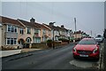
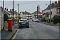
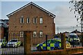
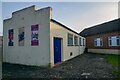
Photos of BS3 5SF
Area Information
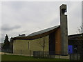
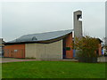
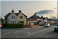
BS3 5SF is a small residential postcode area in the south of Bristol, England, encompassing parts of Filwood Park, Lower Knowle, and Inns Court. With a population of 1,562, it is a compact community characterised by post-war council housing developed in the 1930s as part of a Garden City initiative. The area’s history is marked by social activism, including a failed British Union of Fascists rally in 1931, and community hubs like the Filwood Social Centre, which has served residents since 1938. Daily life here is shaped by its urban residential layout, with a mix of late Art Deco architecture and practical infrastructure. The area is part of Knowle West, a historically deprived ward with challenges such as a diminished high street and limited youth facilities. Despite this, residents benefit from proximity to transport networks, including multiple railway stations and ferry services, and a community centre that remains a focal point. Living in BS3 5SF means navigating a balance between its historical legacy and contemporary issues like council service cuts and anti-social behaviour, while enjoying access to essential amenities within a short reach.
- Area Type
- Postcode
- Area Size
- Not available
- Population
- 1562
- Population Density
- 2911 people/km²
The property market in BS3 5SF is dominated by owner-occupied homes, with 62% of residents owning their properties. The area’s housing stock consists mainly of houses, reflecting its post-war council housing origins. This contrasts with areas dominated by rental properties or newer developments. The small size of the postcode area means that housing options are limited to the existing stock, which includes late Art Deco and mid-20th-century buildings. For buyers, this implies a focus on properties within this specific cluster, with little scope for expansion or new construction. The market is likely to appeal to those prioritising affordability over luxury, given the area’s deprivation status and limited private investment. However, the presence of established infrastructure, such as rail links and community facilities, may offset concerns about property value growth. Buyers should consider the area’s challenges, including council service cuts and anti-social behaviour, when evaluating long-term viability.
House Prices in BS3 5SF
No properties found in this postcode.
Energy Efficiency in BS3 5SF
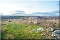
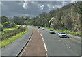
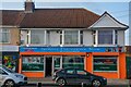
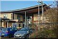
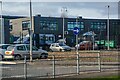
The lifestyle in BS3 5SF is shaped by its proximity to a range of amenities, including retail outlets like Co-op Bedminster, Spar Bedminster, and M&S Imperial Park. The area’s rail network provides access to major destinations, while ferry services connect residents to Bristol’s waterways. Nearby airports and metro stops enhance mobility, though the immediate vicinity lacks large-scale leisure facilities. The Filwood Community Centre, built in 1938, remains a hub for social activities, though the high street’s decline has reduced local shopping options. Residents can access parks and open spaces through Dundry Slopes, offering views and recreational opportunities. The mix of retail, transport, and community spaces creates a functional environment, though the absence of extensive green spaces or cultural venues may limit leisure choices. Daily life here balances practicality with the area’s historical character.
Amenities
Schools
Nearby schools in BS3 5SF include Novers Hill Nursery School, Knowle West Early Years Centre, and Merrywood Girls’ School, which serves primary education. Courtlands Special School is listed twice in the data, offering specialist provision for students with additional needs. The mix of nursery, primary, and special schools reflects a range of educational options for families, though no Ofsted ratings are provided. The presence of a special school indicates a focus on inclusive education, while the nursery and primary schools cater to younger children. However, the absence of secondary schools in the immediate vicinity may require families to seek options further afield. The availability of early years provision is a practical advantage, but parents should consider the broader educational ecosystem beyond the postcode area when planning for their children’s schooling.
| Rank | School | Type | Entry gender | Ages |
|---|
Explore more schools in this area
Go to Schools tabDemographics
The population of BS3 5SF is predominantly adults aged 30–64, with a median age of 47. Home ownership in the area stands at 62%, reflecting a mix of long-term residents and those who have remained in council housing. The accommodation type is primarily houses, though the exact distribution of flats or other property types is not specified. The predominant ethnic group is White, though no further breakdown of diversity is provided. The area is ranked among Bristol’s most deprived wards, with high income deprivation and reliance on incapacity benefits. This context influences quality of life, with limited private sector investment and public services under strain. For example, Filwood Broadway, once a bustling high street with 20 shops, now has shuttered stores, and youth facilities are sparse. These factors shape a community where affordability and stability are priorities, though local amenities like the Filwood Community Centre remain vital.
Household Size
Accommodation Type
Tenure
Ethnic Group
Religion
Household Composition
Age
Household Deprivation
NS-SEC
Explore more demographic insights in this area
Go to Demographics tabPlanning
Planning Constraints
- Flood RiskPremium
- Ramsar Wetland SitesPremium
- Area of Outstanding Natural BeautyPremium
- Protected Nature ReservePremium
- Protected WoodlandPremium