Area Overview for BS29 6NW
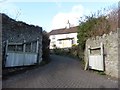
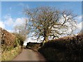
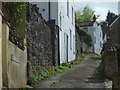
Photos of BS29 6NW


Area Information
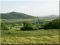
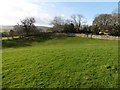
Banwell is a civil parish and village situated in North Somerset, roughly five miles south of Weston-super-Mare. This specific postcode covers a small residential cluster spanning 14.6 hectares. The location sits at the western end of the Mendip Hills on the north side of the Mendip ridge. Its position is defined by proximity to a prolific spring which has historically powered local mills and supplied water to the coast. The village character centres on community facilities including a recreation field gifted in 1902 and a village hall. Nearby parish boundaries include Worle, Wick St Lawrence, Puxton, Winscombe, Christon, Hutton and Locking. The area offers a blend of historic significance and modern residential accommodation. It provides easy access to countryside including Banwell Wood and moorland farms. Residents benefit from being close to the Bristol Channel coast while maintaining a rural setting. The village has grown with development occurring westwards towards Knightcott. Living in BS29 6NW means accessing a space with deep historical roots, from Iron Age hillforts to a 19th-century castle, now surrounded by established housing. The village hall and recreation field serve as focal points for local events and carnivals. This specific cluster of homes offers a quiet life with direct access to natural features and a strong sense of community history.
- Area Type
- Postcode
- Area Size
- 14.6 hectares
- Population
- 1465
- Population Density
- 127 people/km²
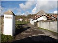
This postcode area displays clear characteristics of an established, owner-occupied market. With 88% home ownership, the vast majority of properties are occupied by their owners rather than tenants. This statistic suggests limited private rental stock within this specific residential cluster. Most homes are houses, fitting the profile of a traditional English village. Buyers looking for properties in BS29 6NW will find an area defined by permanent residents. The property market here likely benefits from low turnover compared to newer estates. Families and retirees may seek homes in this cluster to ensure stability and local integration. The mix of historic structures and council estates from the 1950s and 1960s offers varied architectural styles. Houses dominate the accommodation type landscape. Prospective buyers should anticipate a market where existing tenure is the norm. The high ownership percentage often correlates with stronger community cohesion and local investment in improvements. Those seeking a rental property in this specific area may need to expand their search to adjacent parishes, as this 14.6 hectare zone is overwhelmingly owner-occupied.
House Prices in BS29 6NW
Showing 1 properties
| Address | Type | Beds | Baths | Last Sale Price | Last Sale Date | |
|---|---|---|---|---|---|---|
| Warren Cottage, Winthill, Banwell, BS29 6NW | Detached | - | - | - | - |
Energy Efficiency in BS29 6NW
Residents of BS29 6NW enjoy convenient access to local amenities within practical reach. Five retail options serve daily shopping needs, including The Southern Co-operative Co, Spar Meadow, and Co-op Winscombe. These supermarkets provide essential groceries and household goods without the need for long car journeys. Four rail stations are nearby, offering essential links to Weston and further afield. Worle Railway Station and Weston Milton Railway Station provide commuter routes to Weston-super-Mare and Bristol Temple Meads. A ferry link at Weston adds versatility for coastal travel. Wholesale Co in Weston is noted as a larger retail destination often accessed by locals. The village itself contains a recreation field used for carnivals and events alongside a village hall. Proximity to Banwell Wood and countryside provides immediate leisure opportunities. You can run or walk the nearby Banwell River channels. The lifestyle here balances village convenience with rural peace. Access to food halls, transport hubs, and green spaces means daily tasks are straightforward.
Amenities
Schools
| Rank | School | Type | Entry gender | Ages |
|---|
Explore more schools in this area
Go to Schools tabDemographics
The community in Banwell is established and stable, with an 88% home ownership rate. This figure indicates a residence base where most people have moved to stay long term rather than rent. The population stands at 1465 people across this 14.6 hectare area, resulting in a density of 127 people per square kilometre. Such density suggests a predominantly residential environment where neighbours know one another. The median age within the area is 47 years. Adults aged between 30 and 64 years represent the most common age range for residents. This profile points towards a neighbourhood where families with older children and empty nesters form the demographic core. The predominant ethnic group is White, reflecting the historic settlement patterns of the Mendip Hills region. Housing stock consists primarily of houses, aligning with the rural village character rather than high-density flats. Living here appeals to those who prefer established neighbourhoods over new developments. The high level of property ownership contributes to a community where long-term residents shape local decisions and social norms.
Household Size
Accommodation Type
Tenure
Ethnic Group
Religion
Household Composition
Age
Household Deprivation
NS-SEC
Explore more demographic insights in this area
Go to Demographics tabPlanning
Planning Constraints
- Flood RiskPremium
- Ramsar Wetland SitesPremium
- Area of Outstanding Natural BeautyPremium
- Protected Nature ReservePremium
- Protected WoodlandPremium