Area Overview for BS28 4WB
Photos of BS28 4WB
Area Information
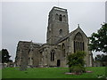
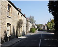
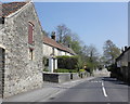
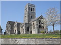
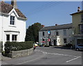
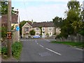
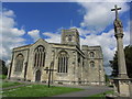
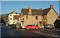
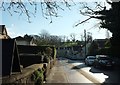
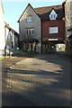
BS28 4WB is a small residential postcode nestled in Wedmore, Somerset, a village with a rich historical legacy. With a population of 1,569 and a low density of 122 people per square kilometre, it offers a quiet, close-knit community feel. Wedmore’s origins as a royal Saxon hunting estate and its role in the 9th-century Peace of Wedmore add a layer of historical significance to daily life here. The area’s geography, situated between the Rivers Axe and Brue on the Somerset Levels, shapes its rural charm, though it remains within reach of nearby towns like Cheddar and Axbridge. Residents benefit from a mix of traditional architecture and modern amenities, with a strong emphasis on local heritage. The village retains its medieval market cross and historic churches, while nearby retail and services cater to everyday needs. This postcode is ideal for those seeking a tranquil, low-density living environment with easy access to both natural landscapes and essential services.
- Area Type
- Postcode
- Area Size
- Not available
- Population
- 1569
- Population Density
- 122 people/km²
The property market in BS28 4WB is dominated by owner-occupied homes, with 79% of properties owned by residents rather than rented. The area is primarily composed of houses, reflecting its rural character and the preference for larger, more private living spaces. This contrasts with urban areas where flats and apartments are more common. The small postcode area suggests a limited number of properties, which may mean competition for buyers seeking homes in this cluster. Given the high home ownership rate, the market is likely to be stable, with properties holding value over time. For buyers, this area offers a chance to invest in a low-density, historic setting, though the limited size of the postcode means opportunities are confined to a specific geographic cluster.
House Prices in BS28 4WB
No properties found in this postcode.
Energy Efficiency in BS28 4WB
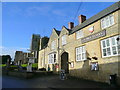
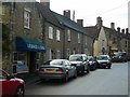
The lifestyle in BS28 4WB is shaped by its proximity to essential amenities, including retail hubs like Sainsburys Cheddar, Tesco Cheddar, and Co-op Axbridge. These stores provide access to groceries, household goods, and other daily necessities, reducing the need for long trips. The area’s rural setting is complemented by nearby historical sites, such as Wedmore’s 14th-century market cross and the Church of St Mary the Virgin, which offer cultural and recreational value. While the postcode itself is small, its connection to Wedmore’s heritage and surrounding villages ensures residents can enjoy a mix of traditional and modern conveniences. The presence of local shops and services contributes to a self-contained, community-oriented lifestyle.
Amenities
Schools
The nearest school to BS28 4WB is Hugh Sexey Church of England Middle School, which operates as both a primary school and an academy with a Good Ofsted rating. This dual role means it serves students from early years through to secondary education, offering a continuous educational pathway for families. The Good rating indicates a school that meets national standards in teaching quality, student outcomes, and overall performance. For parents, this provides a reliable local option without the need to commute to larger towns. The presence of a single school with a strong rating suggests a focused educational environment, though it may lack the diversity of multiple institutions found in larger settlements.
| Rank | School | Type | Entry gender | Ages |
|---|
Explore more schools in this area
Go to Schools tabDemographics
The community in BS28 4WB is predominantly middle-aged, with a median age of 47 and the majority of residents falling within the 30–64 age range. Home ownership is high, at 79%, reflecting a stable, long-term resident base. The area is characterised by houses rather than flats, aligning with its rural and semi-rural nature. The predominant ethnic group is White, which is typical for this part of Somerset. The low population density suggests a spread-out, less congested living environment. While no specific deprivation data is provided, the high home ownership and low crime risk (Safety Score: 86/100) indicate a generally secure and economically stable area. This demographic profile suggests a community focused on family life, with a strong presence of adults in their prime working years.
Household Size
Accommodation Type
Tenure
Ethnic Group
Religion
Household Composition
Age
Household Deprivation
NS-SEC
Explore more demographic insights in this area
Go to Demographics tabPlanning
Planning Constraints
- Flood RiskPremium
- Ramsar Wetland SitesPremium
- Area of Outstanding Natural BeautyPremium
- Protected Nature ReservePremium
- Protected WoodlandPremium