Area Overview for BS26 2AS
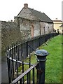
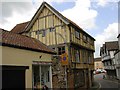
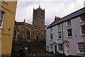
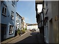
Photos of BS26 2AS
Area Information
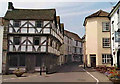
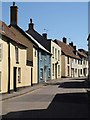
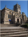
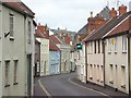
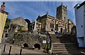
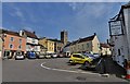
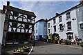
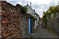
Living in BS26 2AS means residing in a small, tightly knit residential cluster in Somerset, England. With a population of nearly 2,000 and a density of 421 people per square kilometre, this area reflects a compact, community-oriented layout. Nestled on the southern edge of the Mendip Hills, it sits near the River Axe, offering a mix of historic charm and practical connectivity. Axbridge, the town associated with this postcode, has roots in medieval trade, with a surviving 15th-century church and a layout shaped by its past as a cloth-trading hub. Daily life here balances quiet rural character with proximity to Cheddar and the coast, making it a base for those seeking a slower pace without complete isolation. The area’s small size means amenities and services are closely grouped, fostering a sense of familiarity among residents. Its low crime risk and absence of environmental constraints further enhance its appeal, though the population’s median age of 47 suggests a mature, stable community. For buyers, BS26 2AS offers a rare blend of historical significance and modern practicality, ideal for those prioritising safety, space, and a manageable lifestyle.
- Area Type
- Postcode
- Area Size
- Not available
- Population
- 1999
- Population Density
- 421 people/km²
The property market in BS26 2AS is characterised by a high rate of home ownership (71%) and a focus on houses rather than flats or apartments. This suggests a community where long-term residency is common, with properties likely to be family homes rather than investment assets. The predominance of houses indicates a preference for space and privacy, typical of smaller towns with limited high-density development. As a small postcode area, the housing stock is likely limited, which could mean fewer options for buyers but potentially higher demand for available properties. The absence of rental-focused statistics implies a market skewed towards owner-occupation, which may stabilise prices but reduce flexibility for renters. For buyers, this means properties are likely to be well-maintained and suited to those seeking a permanent residence rather than a short-term investment. The area’s compact size also means proximity to amenities and transport links is a key selling point, making it appealing to those prioritising convenience over large-scale developments.
House Prices in BS26 2AS
No properties found in this postcode.
Energy Efficiency in BS26 2AS
The lifestyle in BS26 2AS is shaped by its small-town character and proximity to local amenities. Within practical reach are five retail outlets, including Co-op Axbridge, Tesco Cheddar, and Spar, providing essential shopping options. These venues cater to daily needs, from groceries to household supplies, reducing the need for long trips to larger towns. The area’s historical layout, with its high street and town square, adds to its charm, offering quaint shops and historic buildings. While no specific parks or leisure facilities are listed, the surrounding Mendip Hills suggest opportunities for outdoor activities. The mix of retail and historic architecture creates a convenient, characterful environment where residents can access necessities without sacrificing the quiet appeal of a small community. This balance of practicality and tradition makes daily life in BS26 2AS both efficient and enjoyable.
Amenities
Schools
The schools near BS26 2AS include Axbridge Church of England First School, a primary school with no Ofsted rating listed, and The Cornerstone School, an independent institution. A second academy, Axbridge Church of England First School Academy, is rated ‘good’ by Ofsted. This mix of school types offers families flexibility, from state-funded education to private options. The presence of an academy with a ‘good’ rating suggests at least one school meets high standards for teaching and pupil outcomes. For families seeking a range of educational approaches, the area provides both traditional and independent schooling. However, the lack of detailed performance data for the primary school means prospective parents should investigate further. The proximity of these schools to the postcode area makes them accessible for local residents, supporting the area’s appeal for families. The combination of school types reflects a balance between public and private education, catering to diverse preferences without requiring long commutes.
| Rank | School | Type | Entry gender | Ages |
|---|
Explore more schools in this area
Go to Schools tabDemographics
The community in BS26 2AS is predominantly composed of adults aged 30–64, with a median age of 47. This suggests a mature population, likely with established careers and families. Home ownership is high at 71%, indicating a strong presence of long-term residents and a stable housing market. The area’s accommodation is primarily houses, reflecting a preference for detached or semi-detached properties over flats. The predominant ethnic group is White, though no specific data on diversity or deprivation is provided. The age profile implies a mix of working professionals and retirees, with fewer young families compared to other areas. The high home ownership rate and absence of rental-focused housing suggest a community prioritising permanence. With 1,999 residents, the area is small enough to foster close-knit relationships but large enough to support local services. This demographic profile aligns with a quiet, low-traffic environment where daily life is shaped by routine and familiarity rather than rapid change.
Household Size
Accommodation Type
Tenure
Ethnic Group
Religion
Household Composition
Age
Household Deprivation
NS-SEC
Explore more demographic insights in this area
Go to Demographics tabPlanning
Planning Constraints
- Flood RiskPremium
- Ramsar Wetland SitesPremium
- Area of Outstanding Natural BeautyPremium
- Protected Nature ReservePremium
- Protected WoodlandPremium