Area Overview for BS24 9BH
Photos of BS24 9BH


Area Information
Living in BS24 9BH means residing within a specific residential cluster of 1.9 hectares in Weston-super-Mare, North Somerset. The area currently serves 1,506 residents, placing it in a small but distinct pocket of the wider town. Despite the modest size, the location benefits from a coastal setting typical of the Victorian seaside resort that is Weston-super-Mare. A deep etching of history underpins this community, as the town evolved from a fishing village under a thousand inhabitants in the early 19th century to a major holiday destination. This evolution brought significant development, including the arrival of the railway in 1841 and the construction of key landmarks like the Grand Pier in 1904. Residents of BS24 9BH enjoy access to the high tidal range found along the Bristol Channel coast, known for being the second highest in the world. The proximity to Weston-super-Mare's seafront ramble and the town hall built by James Wilson in 1859 defines the local heritage. The character of the area mirrors the broader town's mix of historic charm and modern convenience. You live close to essential services and rail links without being overwhelmed by the density of a larger city. The postcode area represents a focused residential choice for those who value the established amenities and transport connections of Weston-super-Mare within a compact living environment.
- Area Type
- Postcode
- Area Size
- 1.9 hectares
- Population
- 1506
- Population Density
- 4513 people/km²
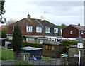
Buying property in BS24 9BH involves entering a market dominated by houses. Houses make up the primary accommodation type within this postcode, meaning you will find a range of single-family homes rather than high-rise apartments or communal flats. With 49% home ownership, nearly half the residents have invested in their own property. This percentage signals a market with significant stability, as one-normally finds more owner-occupiers in areas with high median ages. The other 51% of the population likely rents, which can influence local rental yields for investors looking at the immediate surroundings. The small area size of 1.9 hectares concentrates these housing options. You are looking at a limited selection of properties within the immediate outskirts of BS24 9BH. Buyers in this region typically seek detached or semi-detached dwellings suited to families or those seeking space. The presence of the Old Thatched Cottage Restaurant and the historic architecture of Weston-super-Mare often adds character to these properties. Prices reflect the balance between the affordability of a seaside town and the demand for home ownership in a post-industrial revival area. Anyone considering homes in this postcode should expect to contend with a stock defined by traditional building styles rather than modern urban conversions.
House Prices in BS24 9BH
No properties found in this postcode.
Energy Efficiency in BS24 9BH
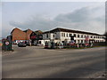
Daily life in BS24 9BH is enriched by a suite of amenities located within practical reach. Residents have access to five retail outlets, including Spar, Morrisons Daily Weston-super, and Tesco Oldmixon. These supermarkets and convenience stores ensure that grocery shopping and quick errands can be completed without travelling far from home. Your options for fresh food and daily necessities are plentiful. Transport links further enhance this convenience. Nearby rail facilities at Weston, Weston Milton, and Worle connect you to regional hubs quickly. A ferry service based in Weston adds another layer of travel flexibility, particularly for visitors from across the Bristol Channel. The lifestyle therefore blends the convenience of suburban living with the accessibility of a major tourist resort. You can walk to shops at Tesco and Spar while enjoying the heritage of the area. The presence of the Grand Pier and seafront walls nearby offers opportunities for leisure walks when the weather is fine. This balance of commercial proximity and coastal access defines the resident experience.
Amenities
Schools
For families living in or near BS24 9BH, education options are centred on local primary provision. The nearest school is Oldmixon Primary School, which serves as the designated educational facility for the local catchment. It holds a primary type classification for students in the early years of schooling. This focus on primary education suggests that secondary schools are located further away, likely requiring bus travel or a longer commute for families with older children. Oldmixon Primary School plays a central role in the educational landscape for this small residential cluster. While the data does not specify Ofsted ratings for this institution, it remains the key local hub for younger pupils. The concentration of two entries for Oldmixon Primary School in the nearby schools list confirms its importance as the principal establishment in the area. Families relocating to BS24 9BH should plan transport logistics accordingly, as access to secondary education requires movement beyond the immediate neighbourhood. The presence of this single primary school defines the local schooling ecosystem, serving the 1,506 residents of the postcode and surrounding vicinity.
| Rank | School | Type | Entry gender | Ages |
|---|
Explore more schools in this area
Go to Schools tabDemographics
The community in BS24 9BH is defined by a mature demographic profile. The median age here is 47 years, falling squarely within the dominant age range of adults aged 30 to 64 years. This indicates a neighbourhood where families and established couples likely form the core of the population rather than young people entering the market alone. In terms of tenure, 49% of residents own their homes outright or with a mortgage. This near-even split suggests a balanced mix between owner-occupiers and renters, though the higher age profile often points towards growing equity among long-term residents. Accommodation types in this postcode are predominantly traditional houses. Most households reside in detached, semi-detached, or terraced properties rather than flats or maisonettes. The predominant ethnic group recorded is White, reflecting the established nature of the South West English coast. While specific deprivation data is not included in the current analysis, the age structure implies a stable, settled community. Families with children aged school-going years and early retirees often form the bulk of the householders in areas with such demographics. The housing stock supports a lifestyle associated with suburban living within easy reach of the coast, catering to those who have moved past their early twenties.
Household Size
Accommodation Type
Tenure
Ethnic Group
Religion
Household Composition
Age
Household Deprivation
NS-SEC
Explore more demographic insights in this area
Go to Demographics tabPlanning
Planning Constraints
- Flood RiskPremium
- Ramsar Wetland SitesPremium
- Area of Outstanding Natural BeautyPremium
- Protected Nature ReservePremium
- Protected WoodlandPremium