Area Overview for BS24 0AT
Photos of BS24 0AT


Area Information
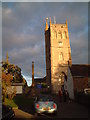
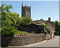
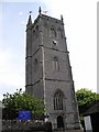
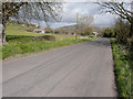
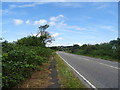
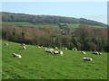
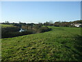
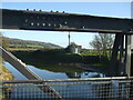
BS24 0AT lies in the village of Bleadon, Somerset, a rural parish on the edge of the North Somerset Levels, where the Mendip Hills meet the Severn Estuary. With a population of 1,427 and a low density of 132 people per square kilometre, it retains a quiet, village-scale character. Residents enjoy proximity to Weston-super-Mare, just 4 miles north, offering coastal amenities, while the area’s historic roots are evident in landmarks like the 14th-century Church of St Peter and St Paul. Daily life here balances traditional rural living with practical connectivity: four railway stations, including Weston and Worle, provide links to nearby towns, and a ferry service to Weston adds to transport options. The community is a mix of long-established families and newer arrivals, creating a diverse yet close-knit environment. Bleadon’s history as a medieval port and its Iron Age heritage add depth to its appeal, though modern infrastructure like broadband remains limited. For those seeking a peaceful, low-density lifestyle with historical interest, BS24 0AT offers a distinct alternative to urban centres.
- Area Type
- Postcode
- Area Size
- Not available
- Population
- 1427
- Population Density
- 132 people/km²
BS24 0AT is primarily an owner-occupied area, with 85% of homes owned by residents rather than rented. The accommodation type is predominantly houses, which aligns with the village’s rural character and low-density development. This contrasts with urban areas where flats and apartments are more common, suggesting that properties here are likely larger, with gardens and private outdoor space. The small size of the postcode area means the housing stock is limited, but the focus on owner-occupation indicates a stable market with long-term residents. For buyers, this implies a potential for property retention and community continuity, though the limited supply may mean competition for available homes. The absence of rental properties also suggests that the area is less transient, which could be appealing for those seeking a settled, long-term residence.
House Prices in BS24 0AT
No properties found in this postcode.
Energy Efficiency in BS24 0AT
Residents of BS24 0AT benefit from nearby amenities that blend practicality with rural charm. Within practical reach are five retail outlets, including Tesco Oldmixon, Morrisons Daily Weston-super, and Spar, ensuring everyday shopping needs are met. Four railway stations—Weston, Weston Milton, and Worle—offer regular services to nearby towns, while a ferry to Weston provides alternative transport for coastal travel. The village’s small size fosters a close-knit community, with local landmarks like the Church of St Peter and St Paul adding historical interest. Though the area is rural, the proximity to Weston-super-Mare means residents can access larger leisure options, dining, and cultural events without long commutes. The combination of local shops, transport links, and a friendly atmosphere creates a lifestyle that balances convenience with the tranquillity of a village setting.
Amenities
Schools
| Rank | School | Type | Entry gender | Ages |
|---|
Explore more schools in this area
Go to Schools tabDemographics
The population of BS24 0AT is predominantly middle-aged, with a median age of 47 and the majority of residents falling within the 30-64 age range. This suggests a community of established professionals and families, with 85% owning their homes—a high rate indicating stability and long-term residency. The area is characterised by houses rather than flats, reflecting a preference for larger, private properties. The predominant ethnic group is White, though the village’s character description notes a mix of local families and newcomers from diverse backgrounds, including singles, couples, and multi-generational households. While no specific deprivation data is provided, the high home ownership rate and low population density suggest a relatively affluent, self-sufficient community. The age profile implies a mature demographic, which may influence local services and amenities, such as healthcare and leisure options tailored to older residents.
Household Size
Accommodation Type
Tenure
Ethnic Group
Religion
Household Composition
Age
Household Deprivation
NS-SEC
Explore more demographic insights in this area
Go to Demographics tabPlanning
Planning Constraints
- Flood RiskPremium
- Ramsar Wetland SitesPremium
- Area of Outstanding Natural BeautyPremium
- Protected Nature ReservePremium
- Protected WoodlandPremium