Area Overview for BS24 0AE
Photos of BS24 0AE


Area Information
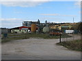
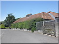
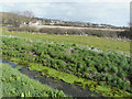
BS24 0AE is a small residential postcode in Somerset, England, encompassing parts of the village of Bleadon. With a population of 1,609, it reflects a tight-knit community at the edge of the North Somerset Levels, where the Mendip Hills meet the Severn Estuary. The area is historically significant, with roots tracing back to the Domesday Book and a medieval sea wall still visible on Bleadon Moor. Daily life here balances rural tranquillity with practical connectivity: residents can reach Weston-super-Mare, a coastal town with shops, transport, and a ferry service, in under 10 minutes. The village’s character is defined by its mix of traditional families and newcomers, creating a diverse yet cohesive social fabric. While the area’s population is slightly higher than the 2021 census figure for Bleadon (1,149), this likely reflects the broader postcode’s inclusion of surrounding clusters. Living here means embracing a slower pace of life, with access to local amenities and a strong sense of community, all within reach of regional hubs.
- Area Type
- Postcode
- Area Size
- Not available
- Population
- 1609
- Population Density
- 1790 people/km²
The property market in BS24 0AE is overwhelmingly owner-occupied, with 94% of homes in private hands. This contrasts with areas where rental demand drives the market, indicating a stable, long-term resident base. The accommodation type is predominantly houses, which aligns with the village’s rural character and the absence of high-density housing. For buyers, this means a focus on individual properties rather than apartments or shared spaces. The small area’s limited size means the housing stock is finite, and proximity to Weston-super-Mare may influence property values. While the data does not specify average prices or trends, the high home ownership rate suggests a strong local demand, potentially limiting availability for new buyers.
House Prices in BS24 0AE
No properties found in this postcode.
Energy Efficiency in BS24 0AE
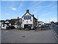
Living in BS24 0AE offers a blend of rural charm and accessible amenities. Within practical reach are retail options like Tesco Oldmixon, Morrisons Daily Weston-super, and Spar, providing daily essentials. The village’s historic character is complemented by nearby leisure opportunities, including the Church of St Peter and St Paul, a Grade I listed building, and the Iron Age burial site of “Bleadon Man.” The three rail stations and Weston ferry ensure easy access to coastal and urban destinations. The area’s friendly community and mix of traditional and modern influences create a lifestyle that balances local heritage with contemporary convenience, ideal for those seeking a peaceful yet connected existence.
Amenities
Schools
| Rank | School | Type | Entry gender | Ages |
|---|
Explore more schools in this area
Go to Schools tabDemographics
The community in BS24 0AE is predominantly composed of adults aged 30–64, with a median age of 47. This suggests a mature, stable population, many of whom are likely long-term residents. Home ownership is exceptionally high at 94%, indicating a strong preference for private property over rentals. The area is characterised by houses rather than flats or apartments, reflecting a traditional, family-oriented housing stock. The predominant ethnic group is White, though the area’s “friendly community of about 1,050 residents” (from research notes) hints at a mix of local families and newer arrivals. The absence of specific deprivation data means no direct commentary on economic hardship, but the high home ownership rate and low flood risk (score 0) suggest a resilient, secure living environment.
Household Size
Accommodation Type
Tenure
Ethnic Group
Religion
Household Composition
Age
Household Deprivation
NS-SEC
Explore more demographic insights in this area
Go to Demographics tabPlanning
Planning Constraints
- Flood RiskPremium
- Ramsar Wetland SitesPremium
- Area of Outstanding Natural BeautyPremium
- Protected Nature ReservePremium
- Protected WoodlandPremium