Area Overview for BS22 9UR
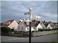
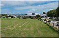
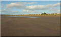
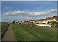
Photos of BS22 9UR

Area Information
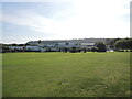
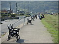
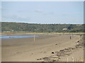
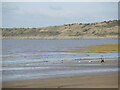
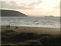
BS22 9UR is a small, tightly knit residential cluster in Somerset, England, encompassing the village of Kewstoke. With a population of 1,870 spread over 3.3 hectares, the area has a low density of 217 people per square kilometre, reflecting its rural character. Kewstoke is steeped in history, with St Paul’s Church, a 12th-century Grade I listed building, and Woodspring Priory, founded in 1210. The village lies near Sand Bay, offering coastal proximity, though the area itself is more defined by its historic buildings and quiet streets. Residents here are predominantly adults aged 30–64, with a median age of 47, suggesting a mature, stable community. Home ownership is high at 79%, with most properties being houses rather than flats. Daily life balances historical charm with practical amenities, including nearby rail stations and a primary school. However, the area’s small size means it is not a hub for large-scale retail or leisure, requiring residents to travel for broader services. The mix of historic sites and modern connectivity, such as broadband and rail links, makes BS22 9UR a unique blend of tradition and convenience.
- Area Type
- Postcode
- Area Size
- 3.3 hectares
- Population
- 1870
- Population Density
- 217 people/km²
BS22 9UR is predominantly an owner-occupied area, with 79% of homes owned by residents rather than rented. The accommodation type is largely houses, which is typical for rural or semi-rural postcode areas. This suggests a housing stock that is older, with traditional properties rather than modern apartments or flats. The small size of the area—just 3.3 hectares—means the number of properties is limited, creating a tight market with fewer options for buyers. For those seeking homes in BS22 9UR, the focus is on existing houses, which may have character features such as historic architecture, as seen in St Paul’s Church and Woodspring Priory. However, the limited availability could make the area competitive for buyers, particularly those prioritising property uniqueness or historical significance. The high home ownership rate also indicates a community with long-term residents, which may influence property values and market dynamics.
House Prices in BS22 9UR
Showing 2 properties
| Address | Type | Beds | Baths | Last Sale Price | Last Sale Date | |
|---|---|---|---|---|---|---|
| B Bungalow, Pontins, 64 Beach Road, Kewstoke, BS22 9UR | hotel | - | - | - | - | |
| New House, Pontins, Beach Road, Kewstoke, BS22 9UR | Detached | - | - | - | - |
Energy Efficiency in BS22 9UR
Life in BS22 9UR is shaped by its small size and historic character. The area offers five retail outlets, including The Radstock Co-operative Society, Co-op Milton Road, Co-op Worle, and Farmfoods Ashcombe Park, providing basic shopping needs. Rail stations at Weston Milton, Weston, and Worle offer access to nearby towns, while a ferry service in Weston connects to coastal routes. The village’s historical sites, such as St Paul’s Church and Woodspring Priory, add cultural value, though they are not listed as amenities in the data. The absence of larger parks or leisure facilities means residents may need to travel for recreational activities. However, the proximity to Sand Bay and nearby woodlands offers outdoor opportunities. The lifestyle here is practical and community-focused, with a balance between historic charm and necessary connectivity for daily living.
Amenities
Schools
The nearest school to BS22 9UR is Kewstoke Primary School, a primary institution serving the local community. The data lists this school twice, but it is likely a single school with two entries. As a primary school, it caters to younger children, though no Ofsted rating is provided in the data. The presence of a primary school is a key consideration for families, offering proximity to education for early years. However, the absence of secondary schools or further education institutions in the immediate area means families may need to travel for older children’s schooling. The single primary school suggests a small student population, which may impact resources and class sizes. For families prioritising local schooling, Kewstoke Primary School is a critical factor, though additional research would be needed to assess its performance.
| Rank | School | Type | Entry gender | Ages |
|---|
Explore more schools in this area
Go to Schools tabDemographics
The population of BS22 9UR is 1,870, with a median age of 47, indicating a community skewed towards middle-aged and older residents. The most common age range is 30–64 years, suggesting a stable demographic with fewer young families. Home ownership is high at 79%, with the majority of properties being houses, reflecting a preference for traditional housing over flats. The predominant ethnic group is White, though specific data on diversity is not provided. The population density of 217 people per square kilometre is relatively low, contributing to a quiet, less congested environment. This density also implies that the area is not densely populated, offering more space per household. However, the lack of data on deprivation or income levels means it is unclear how this affects quality of life. The age profile and ownership rates suggest a community focused on stability and long-term residency, with fewer transient populations.
Household Size
Accommodation Type
Tenure
Ethnic Group
Religion
Household Composition
Age
Household Deprivation
NS-SEC
Explore more demographic insights in this area
Go to Demographics tabPlanning
Planning Constraints
- Flood RiskPremium
- Ramsar Wetland SitesPremium
- Area of Outstanding Natural BeautyPremium
- Protected Nature ReservePremium
- Protected WoodlandPremium