Area Overview for BS20 6XS
Photos of BS20 6XS

Area Information
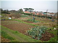
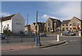
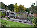
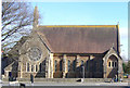
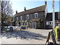
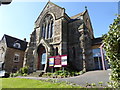
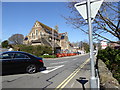
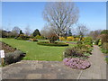
BS20 6XS is a small, tightly knit residential cluster in North Somerset, nestled along the Bristol Channel, approximately 10 miles west of Bristol. With a population of around 1,310, it retains a quiet, suburban character shaped by its historical roots as a fishing port and seaside resort. The area’s topography, defined by raised ground between Church Road North and South, offers natural shelter from coastal winds, a feature that influenced its early development. Today, it blends Victorian-era High Street architecture with modern housing, while the former dock has been repurposed as a marina. The community is accessible via the A369 and nearby motorways, and its proximity to Bristol makes it a draw for commuters. Residents and visitors often refer to it affectionately as “Posset,” a nod to its past as a popular seaside destination. The area’s charm lies in its compact size, historic landmarks like St. Peter’s Church, and the Lake Grounds, a public space dating back to 1910. It is a place where coastal tranquillity meets practical connectivity, ideal for those seeking a balanced lifestyle near major urban centres.
- Area Type
- Postcode
- Area Size
- Not available
- Population
- 1310
- Population Density
- 3204 people/km²
The property market in BS20 6XS is characterised by a high proportion of owner-occupied homes, with 75% of properties owned by residents rather than rented. The accommodation type is predominantly houses, which aligns with the area’s suburban, low-density layout. This suggests a market skewed towards family homes and established residences, rather than apartments or flats. The small size of the postcode area means the housing stock is limited, making it a niche market for buyers seeking a specific location. The presence of historical and coastal features may enhance property values, though the data does not provide specific price ranges. For buyers, this means competition could be fierce, and the selection of homes is likely to be constrained. The area’s proximity to Bristol and its transport links may also appeal to those seeking a balance between rural tranquillity and urban accessibility.
House Prices in BS20 6XS
No properties found in this postcode.
Energy Efficiency in BS20 6XS
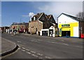
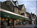
Living in BS20 6XS offers access to a range of amenities within practical reach. Retail options include Aldi Portishead, Iceland Portishead, and Waitrose Portishead, providing everyday shopping convenience. The area’s coastal location is complemented by ferry services to Portishead Pier, Clevedon Pier, and Bristol Docks, offering easy access to water-based recreation. Rail connections to Avonmouth, Portway Park & Ride, and St Andrews Road stations facilitate travel to Bristol and beyond. The Lake Grounds, a public park opened in 1910, provides green space for leisure and exercise. The marina, once a deep-water dock, adds to the area’s maritime character. While the data does not mention dining or entertainment venues, the proximity to Bristol likely expands options for nightlife and cultural activities. The combination of retail, transport, and natural amenities creates a lifestyle that balances coastal charm with practicality.
Amenities
Schools
The only school explicitly mentioned in the data is Quayside Education Centre, a special school serving the area. No other schools are listed, which may indicate a limited range of educational options for families. The presence of a special school suggests the community includes residents with specific educational needs, though the data does not provide information on the school’s Ofsted rating or student outcomes. For families requiring mainstream education, the absence of other schools could be a consideration. The area’s small size may limit the number of schools available, but its proximity to Bristol could offer additional options for students. Parents should investigate further to understand the full range of educational provisions accessible to their children.
| Rank | School | Type | Entry gender | Ages |
|---|
Explore more schools in this area
Go to Schools tabDemographics
The population of BS20 6XS skews towards adults aged 30–64, with a median age of 47. This suggests a community of established professionals and families, rather than a transient or student population. Home ownership is high at 75%, indicating stability and long-term residency. The area is predominantly composed of houses, reflecting a traditional, low-density housing stock. The predominant ethnic group is White, though no specific data on diversity or deprivation is provided. The age profile implies a mature demographic, which may influence local services and amenities. With no mention of younger or elderly populations in the data, it is reasonable to infer that the area caters to middle-aged residents seeking a settled environment. The high home ownership rate also suggests a community with strong ties to the area, likely prioritising long-term investment over short-term rental markets.
Household Size
Accommodation Type
Tenure
Ethnic Group
Religion
Household Composition
Age
Household Deprivation
NS-SEC
Explore more demographic insights in this area
Go to Demographics tabPlanning
Planning Constraints
- Flood RiskPremium
- Ramsar Wetland SitesPremium
- Area of Outstanding Natural BeautyPremium
- Protected Nature ReservePremium
- Protected WoodlandPremium