Area Overview for BS20 6BQ
Photos of BS20 6BQ
Area Information
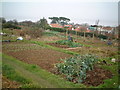
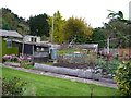
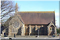
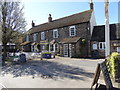
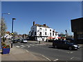
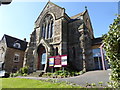
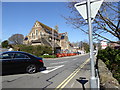
Portishead sits at the edge of the Bristol Channel, approximately ten miles west of Bristol. The postcode BS20 6BQ covers a small residential cluster defined by specific coordinates within this historic civil parish. This area encompasses 5,442 m² of land, creating a compact neighbourhood where residents enjoy immediate proximity to the water. The site originated as a fishing port mentioned in the Domesday Book in 1086, evolving from a settlement of 13 farmers into a Victorian seaside resort. Today, the location blends 12th-century St. Peter's Church with modern housing expansions that replaced post-industrial sites. Living in BS20 6BQ means accessing sheltered topography that has protected the settlement from winds for centuries. You are close to the former deep-water docks converted into the current marina and the recreational Lake Grounds, which opened in 1910. The area feels like a developed coastal community where the historic fishing village roots remain visible alongside tourism and residential life. The postcode represents a finite space where the history of the Bristol Sharp Gazette and local manufacturing firms once thrived before giving way to homes. Buyers here find a direct link to the past without the chaos of a larger urban centre.
- Area Type
- Postcode
- Area Size
- 5442 m²
- Population
- 1310
- Population Density
- 3204 people/km²
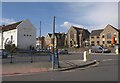
Homes in BS20 6BQ are characterised by a stock that belongs to the majority of residents. With 75% of homes occupied by owners, the market functions primarily as a private residence zone rather than a large-scale letting sector. The predominant accommodation type consists of houses, suggesting a layout that avoids the density of city flats. This structure supports families and individuals seeking detached or semi-detached living arrangements typical of North Somerset. The small area size of 5,442 m² limits the volume of available inventory, meaning properties are likely attractive to those who can locate them. Living in this postcode means you are part of an established residential cluster where the original industrial footprint, such as the former power station and nail factory, has been cleared for housing. The transition from manufacturing sites to modern homes is a defining feature of the local property landscape. Buyers looking at BS20 6BQ find an environment where ownership transcends the status of an asset; it defines the daily rhythm of life. The housing stock reflects the town's evolution from a fishing port to a suburban retreat for Bristol day trippers.
House Prices in BS20 6BQ
Showing 8 properties
| Address | Type | Beds | Baths | Last Sale Price | Last Sale Date | |
|---|---|---|---|---|---|---|
| 11 Stoke Road, Portishead, BS20 6BQ | house | 3 | - | £329,000 | Sep 2012 | |
| 7 Stoke Road, Portishead, BS20 6BQ | house | - | - | £175,000 | Jun 2009 | |
| 5 Stoke Road, Portishead, BS20 6BQ | house | - | - | £272,000 | Nov 2007 | |
| 9 Stoke Road, Portishead, BS20 6BQ | Semi-detached | - | - | - | - | |
| 2 Stoke Road, Portishead, BS20 6BQ | Bungalow | 3 | - | - | - | |
| 2A Stoke Road, Portishead, BS20 6BQ | Bungalow | - | - | - | - | |
| 4 Stoke Road, Portishead, BS20 6BQ | Bungalow | - | - | - | - | |
| 6 Stoke Road, Portishead, BS20 6BQ | Bungalow | - | - | - | - |
Energy Efficiency in BS20 6BQ
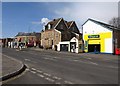
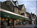
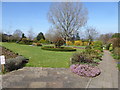
Residents of BS20 6BQ have access to a range of amenities within practical reach for daily errands and leisure. Retail options include Iceland Portishead, Aldi Portishead, and Waitrose Portishead, allowing you to source fresh produce and household goods without long journeys. The area features three ferry docking points at Portishead Pier, Bristol Docks Ferry Landing, and Clevedon Pier, providing direct links across the water. You are near five railway stations including Avonmouth, Portway Park & Ride, and St Andrews Road, offering flexible transport choices. Local history brings landmarks like the 12th-century St. Peter's Church and Court House Farm into your daily view. The Lake Grounds, opened in 1910, provide a permanent open space for recreation. Portishead Marina sits where the 1836 deep-water dock once stood, now serving boats and tourism. Battery Point Lighthouse from 1931 stands near the ancient way along Slade Road. Living in BS20 6BQ connects you to these historical sites while offering modern convenience through the nearby commercial strips.
Amenities
Schools
Families accessing schools near BS20 6BQ have the Quayside Education Centre in their immediate vicinity. This is a special school accommodating 1310 potential local pupils within the broader parish footprint. The presence of a special school indicates that the local provision focuses on specific educational needs rather than a wide mix of primary and secondary institutions. In terms of school education beyond this specific centre, families typically look towards established local offerings within the North Somerset Education Authority jurisdiction, though no other specific school names or Ofsted ratings are listed for this immediate cluster. The existence of the Quayside Education Centre confirms that the area serves as a designated educational hub for specialist requirements. Living in BS20 6BQ means proximity to educational facilities designed for specific learning styles, which is a vital factor for parents requiring specialised support for their children's development.
| Rank | School | Type | Entry gender | Ages |
|---|
Explore more schools in this area
Go to Schools tabDemographics
The community within BS20 6BQ reflects a settled population with a median age of 47 years. Adults between 30 and 64 years constitute the most common age range, indicating a neighbourhood dominated by families and established households rather than transient populations or retirees. This demographic profile suggests stability within the immediate cluster of 1,310 residents. Home ownership stands at a high rate of 75%, meaning most people in the area own their homes outright or with a mortgage. These residents live in houses, which forms the predominant accommodation type for this specific postcode. The population is predominantly White, aligning with the broader historical context of the region since the Roman and Iron Age settlements. Living in BS20 6BQ offers an environment where the majority of neighbours have a long-term stake in the property values and community continuity. The concentration of homeowners indicates that the area attracts buyers looking for permanence rather than the fleeting nature of rental markets. This ownership structure supports a quieter streetscape where residents invest directly in their local infrastructure and public spaces.
Household Size
Accommodation Type
Tenure
Ethnic Group
Religion
Household Composition
Age
Household Deprivation
NS-SEC
Explore more demographic insights in this area
Go to Demographics tabPlanning
Planning Constraints
- Flood RiskPremium
- Ramsar Wetland SitesPremium
- Area of Outstanding Natural BeautyPremium
- Protected Nature ReservePremium
- Protected WoodlandPremium