Area Overview for BS20 6AD
Photos of BS20 6AD

Area Information
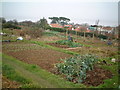
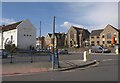
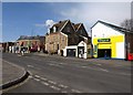
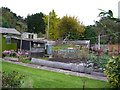
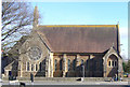
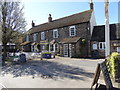
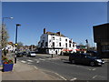
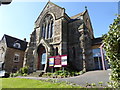
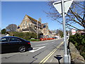
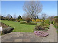
BS20 6AD is a small residential cluster in North Somerset, encompassing the coastal town of Portishead. With a population of around 1,310, it retains a quiet, suburban character shaped by its history as a fishing port and seaside resort. The area’s topography, defined by raised ground between Church Road North and South, offers sheltered views of the Bristol Channel. Today, it blends historic Victorian High Street development with modern housing expansions, including the former dock now transformed into a marina. Residents and visitors often refer to the area affectionately as ‘Posset,’ a nod to its past as a popular destination for Bristol day trippers. The proximity to the A369 and M5 motorways ensures easy access to Bristol, while nearby rail stations and ferry services connect to Clevedon and Bristol Docks. The Lake Grounds, opened in 1910, provide a focal point for recreation, and the 12th-century St. Peter’s Church adds to the town’s heritage. Life here balances coastal charm with practical amenities, making it appealing to those seeking a settled, community-focused lifestyle near major transport links.
- Area Type
- Postcode
- Area Size
- Not available
- Population
- 1310
- Population Density
- 3204 people/km²
BS20 6AD is predominantly an owner-occupied area, with 75% of residents living in their own homes. The accommodation type is primarily houses, which are typical of the suburban and coastal character of Portishead. This suggests a housing stock that includes family homes and single-family properties, likely with gardens and private outdoor space. Given the small size of the postcode area, the property market is limited in scale, with limited scope for new developments. Buyers should consider the proximity to amenities such as the Portishead Marina, Lake Grounds, and nearby rail stations when evaluating properties. The high home ownership rate indicates a stable market, though the small area size means competition for available homes. Those seeking rental properties may find fewer options, as the area is not explicitly noted as a rental hotspot.
House Prices in BS20 6AD
No properties found in this postcode.
Energy Efficiency in BS20 6AD
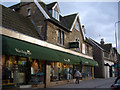
Residents of BS20 6AD have access to a range of amenities within practical reach. The retail sector includes Iceland Portishead, Aldi Portishead, and Waitrose Portishead, offering everyday shopping needs. For leisure, the Portishead Marina, once a deep-water dock, now serves as a recreational hub, while Lake Grounds provide open space for walking and relaxation. The area’s coastal location also allows easy access to ferry services, including Portishead Pier and Clevedon Pier, which connect to nearby towns. The presence of rail stations such as St Andrews Road and Avonmouth Railway Station enhances mobility, linking residents to Bristol’s cultural and commercial centres. The blend of historic sites like St. Peter’s Church and modern facilities creates a lifestyle that balances tradition with convenience, appealing to those who value both community and accessibility.
Amenities
Schools
The nearest school to BS20 6AD is Quayside Education Centre, a special school catering to students with specific educational needs. No other schools are listed in the data, so families relying on mainstream education may need to look beyond the immediate area. The presence of a special school suggests that the community includes residents who require or support specialist educational services. For families seeking a broader range of schools, additional research into nearby towns such as Clevedon or Weston-super-Mare would be necessary. The single school type in the area highlights the importance of considering transport links to access a wider network of educational institutions.
| Rank | School | Type | Entry gender | Ages |
|---|
Explore more schools in this area
Go to Schools tabDemographics
The median age in BS20 6AD is 47, with the majority of residents aged between 30 and 64 years. This suggests a mature, stable population, likely comprising working-age adults and families. Home ownership is high at 75%, reflecting a community where most residents live in their own homes rather than renting. The predominant accommodation type is houses, indicating a mix of family homes and single-family dwellings. The predominant ethnic group is White, though specific diversity statistics are not provided. The age profile suggests a community with established careers and long-term residency, which may influence local services and amenities. With no data on deprivation, it is reasonable to infer that the area’s needs align with those of a middle-aged, owner-occupied population, prioritising stability and access to nearby infrastructure.
Household Size
Accommodation Type
Tenure
Ethnic Group
Religion
Household Composition
Age
Household Deprivation
NS-SEC
Explore more demographic insights in this area
Go to Demographics tabPlanning
Planning Constraints
- Flood RiskPremium
- Ramsar Wetland SitesPremium
- Area of Outstanding Natural BeautyPremium
- Protected Nature ReservePremium
- Protected WoodlandPremium