Area Overview for BS20 0BS
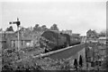
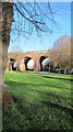
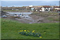
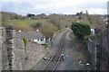
Photos of BS20 0BS

Area Information
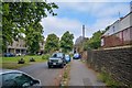
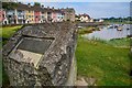
BS20 0BS, covering the civil parish of Pill and Easton-in-Gordano in North Somerset, is a small residential cluster with a population of 1,684. Situated on the River Avon’s banks near Bristol, it blends historical roots with modern living. The area’s name derives from its medieval past, with Easton-in-Gordano recorded in the Domesday Book as a settlement of 24 households. Today, it retains architectural heritage, including St George’s Church, whose tower dates to the 13th century, and Christ Church Pill, established in 1861. The parish includes 28 listed buildings and historic gardens, reflecting its long-standing cultural significance. Despite its compact size, the area offers a mix of quiet residential life and proximity to Bristol’s amenities. Its location near the River Avon and historical sites like Crockerne Pill, once a chapel site, gives it a distinct character. For buyers, BS20 0BS represents a chance to live in a community with preserved heritage, low flood risk, and practical transport links to nearby towns and cities.
- Area Type
- Postcode
- Area Size
- Not available
- Population
- 1684
- Population Density
- 5394 people/km²
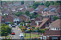
The property market in BS20 0BS is characterised by a 54% home ownership rate, with houses forming the predominant accommodation type. This suggests a residential area where owner-occupation is common, likely attracting buyers seeking traditional, family-oriented homes. The relatively small population and clustered nature of the postcode imply limited housing stock, which could mean competition for available properties. As a small area, the market may be influenced by nearby towns like Bristol, where larger amenities and employment opportunities are located. The focus on houses rather than flats or apartments indicates a preference for larger, more private living spaces. For buyers, this means a market with limited but potentially stable options, where properties are likely to be well-maintained and reflect the area’s historical character. The immediate surroundings may offer additional property choices, but the data does not specify them.
House Prices in BS20 0BS
No properties found in this postcode.
Energy Efficiency in BS20 0BS
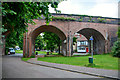
Living in BS20 0BS offers a blend of local retail and transport convenience. Nearby shops include Spar Station Road, The Southern Co-operative Co, and Co-op Shirehampton, providing essentials for daily needs. The area’s rail stations, such as Shirehampton and Portway Park & Ride, offer easy access to Bristol’s urban centres, while ferry landings like Bristol Docks and Portishead Pier connect to water-based travel. Bristol Filton Airport adds to the area’s accessibility. The presence of multiple retail and transport hubs within practical reach means residents can access shopping, dining, and travel options without long commutes. This mix of amenities supports a lifestyle that balances local convenience with broader connectivity, making BS20 0BS suitable for those who value accessibility without sacrificing the area’s quieter, residential charm.
Amenities
Schools
| Rank | School | Type | Entry gender | Ages |
|---|
Explore more schools in this area
Go to Schools tabDemographics
The population of BS20 0BS has a median age of 47, with the majority of residents aged 30–64. This suggests a community skewed toward middle-aged adults, likely including families and professionals. Home ownership stands at 54%, indicating a mix of owner-occupied and rental properties. The predominant accommodation type is houses, reflecting a residential area with more spacious, traditional housing stock. The predominant ethnic group is White, with no specific data provided on other demographics. This age profile and ownership rate suggest a stable, long-term resident base. The absence of detailed diversity metrics means the community’s cultural composition remains less defined in the data. The median age also implies a mature population, potentially influencing local services and amenities. For buyers, this demographic profile may indicate a focus on family-friendly housing and community continuity.
Household Size
Accommodation Type
Tenure
Ethnic Group
Religion
Household Composition
Age
Household Deprivation
NS-SEC
Explore more demographic insights in this area
Go to Demographics tabPlanning
Planning Constraints
- Flood RiskPremium
- Ramsar Wetland SitesPremium
- Area of Outstanding Natural BeautyPremium
- Protected Nature ReservePremium
- Protected WoodlandPremium