Area Overview for BS2 9BB
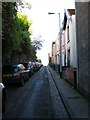
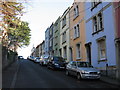
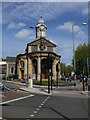
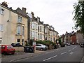
Photos of BS2 9BB


Area Information
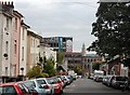
BS2 9BB is a small, densely populated residential postcode in Bristol, England, covering just 1,922 square metres and home to 1,966 people. Despite its compact size, the area is rich in history and character, nestled northeast of the city centre near the M32 motorway. It includes parts of neighbourhoods like St Werburgh’s and Montpelier, known for their mix of Victorian architecture, cobblestone streets, and a reputation for creative energy. The area has undergone gentrification, shifting from historically deprived zones like Stokes Croft to a more stable, middle-class community. With easy access to transport networks and a range of local amenities, BS2 9BB offers a blend of urban convenience and historical charm. Its proximity to the motorway and rail links makes it a practical choice for commuters, while its community-focused vibe—evident in local initiatives like the Vocalise magazine—adds to its appeal. Living here means navigating a bustling, ethnically diverse environment with a strong sense of local identity, though the high population density may affect space and privacy.
- Area Type
- Postcode
- Area Size
- 1922 m²
- Population
- Not available
- Population Density
- Not available
BS2 9BB is primarily an owner-occupied area, with 62% of residents living in homes they own. The accommodation type is largely houses, which is notable given the postcode’s small size and high population density. This suggests a mix of semi-detached and terraced housing, typical of inner-city Bristol. The dominance of owner-occupied properties indicates a stable market, though the area’s small footprint means competition for homes is likely fierce. Buyers should expect limited availability, with properties potentially priced higher due to the area’s proximity to transport links and amenities. The presence of historic and Victorian-era homes adds character but may also mean older infrastructure. For those seeking rental options, the market may be thinner, as the area is more geared toward long-term residents. Prospective buyers should consider the area’s compact nature and the potential for rising property values amid ongoing gentrification.
House Prices in BS2 9BB
No properties found in this postcode.
Energy Efficiency in BS2 9BB
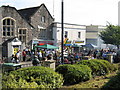
The lifestyle in BS2 9BB is shaped by its mix of retail, transport, and community amenities. Within walking distance are five retail outlets, including Spar Mina and The Southern Co-operative, offering everyday essentials. The area’s rail links, such as Montpelier and Stapleton Road stations, provide easy access to Bristol’s cultural and commercial hubs. Ferry landings like St Philip’s Bridge offer scenic routes across the city. The presence of Bristol Filton Airport, though not a major international hub, adds to the area’s connectivity. Locally, the community magazine Vocalise and historic spaces like St Andrew’s Park contribute to a sense of place. While the area lacks large-scale leisure facilities, its proximity to the city centre means residents can access museums, theatres, and parks. The compact nature of BS2 9BB means amenities are concentrated, encouraging a walkable, convenience-focused lifestyle. However, the high population density may limit private outdoor space, making communal areas and nearby green spaces essential for residents.
Amenities
Schools
BS2 9BB is served by a range of schools, including St Werburghs Park Nursery School, which provides early education, and several primary schools such as Cutlers Brook Junior School, Willow Green Infant School, and St Werburgh’s Primary School. Notably, St Werburgh’s Primary School has an Ofsted rating of “good,” reflecting its quality of education. The mix of nursery and primary schools ensures families have options for early years education and primary schooling. However, the absence of secondary schools in the immediate area may require students to travel to nearby postcodes. For parents, the availability of a “good”-rated primary school is a strong point, though the lack of secondary provision could be a consideration for families planning long-term in the area. The concentration of schools suggests a community focused on education, with local institutions playing a central role in daily life.
| Rank | School | Type | Entry gender | Ages |
|---|
Explore more schools in this area
Go to Schools tabDemographics
BS2 9BB’s population skews towards adults aged 30–64, with a median age of 47. This suggests a mature, established community rather than a transient one. Home ownership is strong here, with 62% of residents owning their homes, indicating stability and long-term investment in the area. The accommodation type is predominantly houses, which is unusual for a high-density urban postcode, hinting at a mix of semi-detached and terraced properties. Ethnically, the area is diverse, with 33.5% of residents from Black, Asian, and Minority Ethnic backgrounds and 23.8% born outside the UK. This diversity contributes to a dynamic cultural landscape. However, the area’s history of deprivation—particularly in parts like Stokes Croft—means some residents may still face socioeconomic challenges. The high proportion of older adults and long-term residents suggests a community with deep-rooted connections, though the gentrification process has brought rising rents and shifting demographics.
Household Size
Accommodation Type
Tenure
Ethnic Group
Religion
Household Composition
Age
Household Deprivation
NS-SEC
Explore more demographic insights in this area
Go to Demographics tabPlanning
Planning Constraints
- Flood RiskPremium
- Ramsar Wetland SitesPremium
- Area of Outstanding Natural BeautyPremium
- Protected Nature ReservePremium
- Protected WoodlandPremium