Area Overview for BS2 8EL
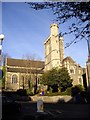
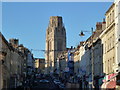
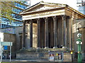
Photos of BS2 8EL


Area Information
BS2 8EL is a small residential postcode area in England, home to 2,386 people. Its compact size means it is a tightly knit community, likely centred around local amenities and transport links. The area’s demographics suggest it is a youthful place, with a median age of 22 and most residents aged between 15 and 29. This hints at a population skewed towards students, young professionals, or those in early careers. The housing stock is predominantly flats, with only 26% of homes owned by residents, indicating a rental-heavy market. While the area lacks specific historical or cultural details in the data, its proximity to Bristol’s central amenities—such as Queen Square and The Centre—suggests it benefits from the city’s urban vibrancy. Residents likely enjoy a mix of modern living and access to nearby green spaces, though the data does not confirm specific parks or recreational areas. The area’s small footprint means it is probably surrounded by other postcodes with similar characteristics, creating a cohesive local environment. For buyers, the challenge lies in understanding whether this is a transient or stable community, but the low flood risk and absence of environmental constraints make it a practical choice for those prioritising safety and accessibility.
- Area Type
- Postcode
- Area Size
- Not available
- Population
- 2386
- Population Density
- 7935 people/km²
The property market in BS2 8EL is characterised by a high proportion of rental flats, with only 26% of homes owned by residents. This suggests the area is not a traditional owner-occupied neighbourhood but rather one where tenants predominate. The dominance of flats indicates a focus on compact, urban living, which may appeal to young professionals or students seeking affordability in a city setting. However, the low home ownership rate also means the market is likely competitive for buyers, with limited opportunities for long-term investment. The small size of the postcode area means property choices are constrained, and buyers may need to look beyond BS2 8EL for more options. For those considering purchase, the area’s rental-heavy nature could signal a lack of stability, though the absence of planning constraints or environmental risks may make it a pragmatic choice for those prioritising location over ownership.
House Prices in BS2 8EL
No properties found in this postcode.
Energy Efficiency in BS2 8EL
Residents of BS2 8EL have access to a range of amenities within practical reach. The retail sector includes major names like Co-op High, M&S Bristol, and Tesco Bristol, providing convenience for daily shopping needs. Rail stations such as Clifton Down and Redland offer easy access to Bristol’s cultural and commercial hubs, while ferry landings like Welsh Back and Castle Park provide scenic travel options. The nearby Bristol Filton Airport caters to those requiring air travel. The area’s proximity to Queen Square and The Centre—both urban open spaces—suggests opportunities for leisure and relaxation, though specific parks are not listed in the data. The mix of retail, transport, and recreational options indicates a lifestyle that balances urban convenience with connectivity, though the absence of detailed local parks or community facilities may require further exploration.
Amenities
Schools
The area is served by two primary schools: St Michael’s on the Mount Church of England Primary School and Willow Park CofE Primary School. Both are state-funded institutions, though Willow Park has an Ofsted rating of ‘inadequate’, which may raise concerns for families prioritising educational quality. St Michael’s on the Mount is not rated in the data, but its name suggests it is likely a similar type of school. The presence of two primary schools within proximity indicates some level of family-friendly infrastructure, though the disparity in ratings highlights variability in educational standards. For parents, this means careful research is needed to assess which school aligns with their child’s needs. The lack of secondary schools in the data means families may need to look further afield for comprehensive education, which could impact long-term residential decisions.
| Rank | School | Type | Entry gender | Ages |
|---|
Explore more schools in this area
Go to Schools tabDemographics
BS2 8EL has a median age of 22, with the majority of its population aged between 15 and 29. This suggests a community dominated by young adults, possibly students or those in early careers. Only 26% of homes are owner-occupied, with flats making up the predominant accommodation type. This indicates a rental market where long-term residency may be less common. The data does not provide information on diversity, but the predominant ethnic group is listed as White. The age profile and low home ownership rate imply a transient population, which could affect the social fabric of the area. For families, the lack of data on deprivation or household composition means it is unclear whether the area supports long-term settlement. However, the presence of two primary schools nearby suggests some level of family-friendly infrastructure. The young demographic may mean the area is more suited to single occupants or couples rather than larger families.
Household Size
Accommodation Type
Tenure
Ethnic Group
Religion
Household Composition
Age
Household Deprivation
NS-SEC
Explore more demographic insights in this area
Go to Demographics tabPlanning
Planning Constraints
- Flood RiskPremium
- Ramsar Wetland SitesPremium
- Area of Outstanding Natural BeautyPremium
- Protected Nature ReservePremium
- Protected WoodlandPremium