Area Overview for BS2 2AG
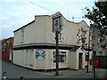
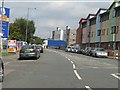
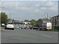
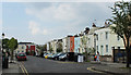
Photos of BS2 2AG

Area Information
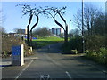
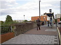
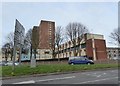
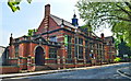
BS2 2AG lies within the Lawrence Hill electoral ward in east Bristol, a historically rich area with roots tracing back to the 12th century. The postcode covers a small residential cluster near Broadmead, Easton, and Temple Meads, blending urban convenience with historical legacy. With a population of 2,560, the area is compact but well-connected, situated near major roads like the A420 and A4320. Its proximity to the Broadmead shopping area and the start of the Bristol and Bath Railway Path offers both practicality and leisure. The ward includes mid-20th-century tower blocks such as Kingsmarsh House, alongside revitalisation projects targeting the high street. Young adults dominate the population, reflecting a dynamic, possibly student or young professional demographic. Living here means navigating a mix of modern housing and historical sites, with transport links to Bristol’s rail network and nearby ferry services enhancing mobility. The area’s character is defined by its compact scale, accessible amenities, and a focus on urban renewal.
- Area Type
- Postcode
- Area Size
- Not available
- Population
- Not available
- Population Density
- Not available
The property market in BS2 2AG is characterised by a low home ownership rate of 12%, suggesting that the area is predominantly a rental market. Flats dominate the housing stock, likely due to the presence of mid-20th-century tower blocks such as Kingsmarsh House and Baynton Houses. This configuration implies limited availability of owner-occupied properties, with buyers facing competition in a small, compact area. The prevalence of flats may appeal to those seeking affordable, manageable living spaces, but it also means the market is less diverse in terms of property types. For buyers, this small postcode’s immediate surroundings offer few alternatives, making proximity to amenities and transport a key consideration. The rental focus may also influence property values, with potential for growth tied to broader Bristol market trends.
House Prices in BS2 2AG
No properties found in this postcode.
Energy Efficiency in BS2 2AG
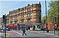
Residents of BS2 2AG have access to a range of amenities within practical reach. Retail options include Lidl Easton, Iceland Easton, and Sainsburys Bristol, providing everyday shopping needs. The area’s rail stations connect to broader networks, while ferry services offer river crossings. The nearby Broadmead shopping area adds to the retail appeal. The proposed revitalisation of the high street near the train station hints at future improvements in dining and community spaces. The presence of the Bristol and Bath Railway Path allows for leisurely walks or cycles, blending urban life with green spaces. Though the data does not mention parks explicitly, the proximity to the river and historical sites suggests opportunities for outdoor activities. The mix of retail, transport, and planned development contributes to a functional, if compact, lifestyle.
Amenities
Schools
Near BS2 2AG are Rosemary Nursery School and Children’s Centre, which provides early years education, and St Nicholas of Tolentine Catholic Primary School, listed three times in the data. While the exact Ofsted ratings are not provided, the presence of both nursery and primary schools suggests a mix of educational options for families. The repetition of St Nicholas of Tolentine’s name may indicate proximity to multiple campuses or a shared facility. For parents, this combination offers continuity in education from early years through primary schooling. However, the lack of secondary school data means families may need to look beyond the immediate area for comprehensive schooling. The availability of nursery care and a Catholic primary school could align with specific educational preferences, though broader options remain unclear.
| Rank | School | Type | Entry gender | Ages |
|---|
Explore more schools in this area
Go to Schools tabDemographics
BS2 2AG has a median age of 22, with the majority of residents aged 15–29. This young demographic suggests a community skewed toward students, graduates, or early-career professionals. Home ownership is low, at just 12%, indicating a rental-dominated market. The primary accommodation type is flats, reflecting a housing stock shaped by post-war development and modern apartment blocks. The predominant ethnic group is White, though specific data on diversity beyond this is not provided. The low home ownership rate and youthful population may signal a transient community, with residents prioritising flexibility over long-term residency. For quality of life, this profile implies a focus on affordability and proximity to services, though the limited ownership rate could affect property value stability.
Household Size
Accommodation Type
Tenure
Ethnic Group
Religion
Household Composition
Age
Household Deprivation
NS-SEC
Explore more demographic insights in this area
Go to Demographics tabPlanning
Planning Constraints
- Flood RiskPremium
- Ramsar Wetland SitesPremium
- Area of Outstanding Natural BeautyPremium
- Protected Nature ReservePremium
- Protected WoodlandPremium