Area Overview for BS19 3SX
Photos of BS19 3SX

Area Information
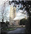
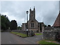
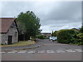
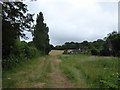
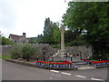
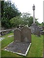
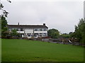
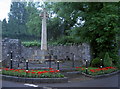
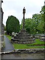
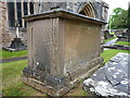
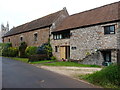
BS19 3SX, located in Backwell, North Somerset, is a small residential cluster with a population of 1,584 people spread across 132 residents per square kilometre. Situated approximately 7 miles west-south-west of Bristol, this area blends historical significance with practical modern living. Backwell’s origins trace back to the Domesday Book, with its name derived from an ancient well on a hill. Today, it includes hamlets like Church Town and West Town, offering a quiet, village-like atmosphere near Nailsea railway station. The area is defined by low-density housing, predominantly owner-occupied homes, and a community skewed toward adults aged 30–64. Residents benefit from proximity to Bristol’s amenities, with rail links to the city and nearby airports. The postcode’s compact size means a tight-knit neighbourhood where local landmarks like St. Andrew’s Church and Backwell House coexist with modern conveniences such as Spar and Tesco. Living here offers a balance of historical charm and accessible infrastructure, ideal for those seeking a stable, low-risk environment with easy connectivity to larger urban centres.
- Area Type
- Postcode
- Area Size
- Not available
- Population
- 1584
- Population Density
- 132 people/km²
The property market in BS19 3SX is characterised by high home ownership (82%) and a predominance of houses over flats or apartments. This suggests a demand for private, family-oriented housing with potential for long-term value retention. The area’s small size means the housing stock is limited, likely centred around traditional homes with gardens, reflecting its semi-rural setting. As an owner-occupied area, it may appeal to buyers seeking stability and a sense of community rather than speculative investment. The lack of rental properties indicates a lower turnover rate, which could benefit buyers looking for a durable asset. Proximity to rail links and Bristol’s infrastructure adds to its appeal, though the limited size of the postcode means competition for available properties could be intense. For those prioritising space, privacy, and a low-risk environment, BS19 3SX offers a compelling case.
House Prices in BS19 3SX
No properties found in this postcode.
Energy Efficiency in BS19 3SX
Residents of BS19 3SX have access to a mix of retail, transport, and leisure amenities within practical reach. Local shops include Spar, The Southern Co-operative Co, and Tesco Bristol, offering everyday essentials. Rail stations like Nailsea & Backwell and Yatton provide links to Bristol and other towns, while nearby ferry landings such as Pumphouse Ferry Landing add connectivity to waterways. The area’s proximity to Bristol Airport and the presence of multiple rail stations enhance mobility for travel and commuting. Though the postcode itself is small, the surrounding region offers a range of services, from retail to transport hubs. The blend of traditional village charm with modern infrastructure supports a lifestyle that balances convenience with a sense of community, though residents may need to travel further for more specialised amenities.
Amenities
Schools
The nearest school to BS19 3SX is Fairfield PNEU School, an independent institution. Independent schools typically offer smaller class sizes, specialist facilities, and a focus on individualised education, though they often require higher fees than state schools. This school’s presence may attract families seeking alternative educational options, though no Ofsted rating is provided in the data. The absence of other listed schools suggests limited state education choices in the immediate vicinity, which could influence decisions for families prioritising a range of options. For those requiring independent schooling, Fairfield PNEU School provides a viable resource, but prospective buyers should consider the broader educational landscape beyond the postcode’s boundaries.
| Rank | School | Type | Entry gender | Ages |
|---|
Explore more schools in this area
Go to Schools tabDemographics
The population of BS19 3SX is predominantly adults aged 30–64, with a median age of 47. This suggests a mature, settled community, likely with strong family ties and long-term residency. Home ownership is high at 82%, indicating a stable housing market with a focus on private residences rather than rentals. The accommodation type is primarily houses, reflecting a suburban or semi-rural character. The predominant ethnic group is White, though no specific diversity statistics are provided. The low population density of 132 people per square kilometre implies spacious living conditions, potentially with larger gardens or outdoor spaces. This demographic profile aligns with a community prioritising security, long-term investment, and a slower pace of life. The absence of specific deprivation data means the area’s quality of life is inferred from its safety, infrastructure, and amenities, which appear robust based on available assessments.
Household Size
Accommodation Type
Tenure
Ethnic Group
Religion
Household Composition
Age
Household Deprivation
NS-SEC
Explore more demographic insights in this area
Go to Demographics tabPlanning
Planning Constraints
- Flood RiskPremium
- Ramsar Wetland SitesPremium
- Area of Outstanding Natural BeautyPremium
- Protected Nature ReservePremium
- Protected WoodlandPremium