Area Overview for BS19 1PT
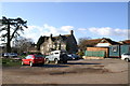
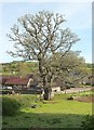
Photos of BS19 1PT


Area Information
Living in BS19 1PT means inhabiting a small, tightly knit residential cluster in North Somerset, England. The area’s population of 1,809 residents, spread across 220 people per square kilometre, reflects a compact, low-density community. Nestled near Bristol, it straddles the historic villages of Long Ashton and Leigh Woods, with roots tracing back to Saxon times and the Domesday Book. The area’s layout follows the main road for nearly two miles, flanked by brooks like Longmoor Brook, giving it a rural yet accessible character. Daily life here is shaped by its proximity to natural features and historical landmarks, such as the parish church of All Saints and the Ashton Court Estate. While the population is small, the area is served by multiple rail stations, including Nailsea & Backwell and Shirehampton, linking residents to Bristol and beyond. The mix of historic architecture and modern amenities, such as Co-op Long and Spar, ensures a balance between tradition and convenience. This is a place where community ties are strong, and the landscape offers both quiet charm and practical connectivity.
- Area Type
- Postcode
- Area Size
- Not available
- Population
- 1809
- Population Density
- 220 people/km²
The property market in BS19 1PT is defined by high home ownership (91%) and a predominance of houses. This suggests a community of long-term residents with a strong attachment to their properties, likely contributing to stable property values. The focus on houses rather than flats or apartments indicates a preference for private, low-density living, which is typical of rural or semi-rural areas. For buyers, this means a limited rental market and a focus on owner-occupied homes. The small size of the area (1809 residents) implies that properties are likely to be in close proximity to one another, with limited scope for expansion. The absence of large-scale development or commercial zones means the housing stock remains traditional, with potential for characterful properties. However, the high ownership rate may also mean fewer opportunities for investment in rental properties. Buyers should consider the area’s appeal to those seeking a quiet, established home rather than a growing urban market.
House Prices in BS19 1PT
No properties found in this postcode.
Energy Efficiency in BS19 1PT
The lifestyle in BS19 1PT is shaped by its proximity to retail, transport, and natural amenities. Local shops include Co-op Long, Spar, and The Southern Co-operative Co, offering everyday essentials within walking distance. The area’s rail network, with stations like Parson Street and Shirehampton, links residents to Bristol’s cultural and commercial hubs. Nearby, Bristol Airport and ferry landings provide regional connectivity, while the River Avon and surrounding brooks offer scenic, low-traffic environments. The historic parish church of All Saints and Ashton Court Estate add cultural and architectural interest. For leisure, the area’s small size means amenities are concentrated, but the presence of multiple rail stations and ferry routes ensures access to larger cities and attractions. The balance of local convenience and regional reach makes daily life practical, with a focus on community and heritage.
Amenities
Schools
| Rank | School | Type | Entry gender | Ages |
|---|
Explore more schools in this area
Go to Schools tabDemographics
BS19 1PT has a median age of 47, with the majority of residents falling into the 30–64 age range. This suggests a mature, stable population, likely with established careers and family ties. Home ownership is exceptionally high at 91%, indicating a community of long-term residents rather than transient renters. The predominant accommodation type is houses, which aligns with the area’s low density and rural character. The population is predominantly White, with no specific data on other ethnic groups provided. The age profile and ownership rates imply a low turnover of properties, fostering a sense of continuity. However, the lack of younger households or diverse demographics may affect the vibrancy of local amenities. For buyers, this means a market with strong equity retention but potentially limited demand for newer housing stock. The absence of explicit data on deprivation or income levels means the quality of life must be inferred from the area’s safety and infrastructure.
Household Size
Accommodation Type
Tenure
Ethnic Group
Religion
Household Composition
Age
Household Deprivation
NS-SEC
Explore more demographic insights in this area
Go to Demographics tabPlanning
Planning Constraints
- Flood RiskPremium
- Ramsar Wetland SitesPremium
- Area of Outstanding Natural BeautyPremium
- Protected Nature ReservePremium
- Protected WoodlandPremium