Area Overview for BS16 5XJ
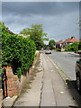
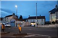
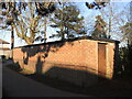
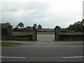
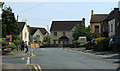
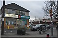
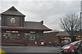
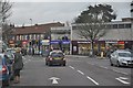
Photos of BS16 5XJ
Area Information
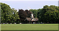
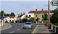
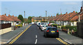
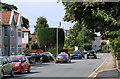
BS16 5XJ is a small, residential postcode area in South Gloucestershire, part of the Downend and Bromley Heath civil parish. With a population of 1,757, it reflects a suburban character shaped by post-war housing developments on former farmland. The area retains historic elements, such as the W.G. Grace Memorial Pavilion and Christ Church, alongside modern infrastructure bounded by the M4 motorway and ring road. Daily life here balances quiet residential living with proximity to amenities like Sainsburys Bristol and multiple railway stations. The community is rooted in its past, from 16th-century references to "Downing" to the 1950s housing boom. Its compact size means residents share a tight-knit environment, with easy access to schools, transport, and local landmarks. The low flood risk and crime score of 71/100 suggest a stable, secure place to live, while broadband rated 98/100 ensures reliable digital connectivity. This is a place where history and convenience coexist, ideal for those seeking a settled, family-oriented lifestyle near Bristol’s urban core.
- Area Type
- Postcode
- Area Size
- Not available
- Population
- Not available
- Population Density
- Not available
BS16 5XJ is predominantly a home-ownership area, with 73% of properties owned by residents rather than rented. The accommodation type is primarily houses, which is typical of suburban settings. This suggests a market skewed toward owner-occupied properties, with fewer rental options available. The small size of the postcode area means the housing stock is limited, and buyers should consider the proximity to nearby suburbs for more options. The presence of established homes, some dating to the 1950s–1960s, indicates a mix of older properties and newer developments. For buyers, this area offers a stable, low-risk investment with strong community ties. However, the limited number of properties may mean competition for available homes. The focus on houses rather than flats or apartments aligns with the area’s suburban identity, appealing to those seeking larger, family-friendly homes.
House Prices in BS16 5XJ
No properties found in this postcode.
Energy Efficiency in BS16 5XJ
Residents of BS16 5XJ have access to a range of amenities within practical reach. Retail options include Co-op Downend, Morrisons Daily, and Sainsburys Bristol, ensuring everyday shopping needs are met. The area’s transport links, such as railway stations and ferry terminals, provide convenience for commuting and leisure travel. Historic sites like the W.G. Grace Memorial Pavilion and Lincombe Barn add cultural value, while parks and open spaces, such as Britannia Wood, offer recreational opportunities. The mix of retail, transport, and heritage sites creates a lifestyle that balances convenience with character. The proximity to Bristol’s urban amenities, combined with suburban tranquility, makes this area appealing for those seeking both accessibility and a sense of community.
Amenities
Schools
The nearest school to BS16 5XJ is Christ Church, Church of England Infant School in Downend, a primary school with an Ofsted rating of "good." This school serves younger children, but families requiring secondary education may need to look to nearby areas, as no secondary schools are listed in the data. The presence of a well-rated primary school enhances the area’s appeal for families with young children. The school’s rating suggests a focus on quality education, though the absence of secondary options means parents should plan for commuting to nearby towns. The single school listed reflects the small size of the postcode area, where educational facilities are concentrated in nearby suburbs.
| Rank | School | Type | Entry gender | Ages |
|---|
Explore more schools in this area
Go to Schools tabDemographics
The population of BS16 5XJ is 1,757, with a median age of 47, indicating a mature community. The most common age group is adults aged 30–64, reflecting a mix of established residents and families. Home ownership is high at 73%, suggesting a stable, long-term demographic. The predominant accommodation type is houses, aligning with the suburban character of the area. The predominant ethnic group is White, though the data does not specify further diversity metrics. This age profile and ownership rate imply a community focused on long-term residency, with fewer transient populations. The absence of detailed deprivation data means the quality of life is inferred from safety and infrastructure: low crime rates and good broadband connectivity support a comfortable lifestyle. The area’s demographics suggest a balance between older residents and families, with limited rental activity due to high ownership.
Household Size
Accommodation Type
Tenure
Ethnic Group
Religion
Household Composition
Age
Household Deprivation
NS-SEC
Explore more demographic insights in this area
Go to Demographics tabPlanning
Planning Constraints
- Flood RiskPremium
- Ramsar Wetland SitesPremium
- Area of Outstanding Natural BeautyPremium
- Protected Nature ReservePremium
- Protected WoodlandPremium