Area Overview for BS15 2HX
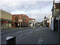
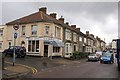
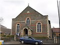
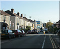
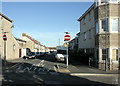
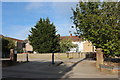
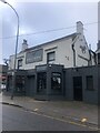
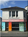
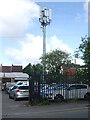
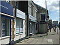
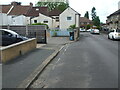
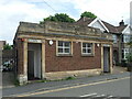
Photos of BS15 2HX
Area Information
BS15 2HX is a small residential postcode area nestled in South Gloucestershire, approximately 3½ miles northeast of Bristol. With a population of 1,976, it reflects a quiet, suburban character shaped by its historical roots as a former village and royal forest. The area’s proximity to the Bristol and Gloucester railway, along with nearby stations like Stapleton Road and Keynsham, underscores its role as a commuter hub. Today, it is a largely residential suburb with a mix of older homes and subdivided properties, many of which date back to the 19th century. The community is anchored by its historical ties to Methodism, with a legacy of religious reform and education. While the area has evolved from its coal-mining past, it retains a distinct identity through its churches, independent chapels, and historic landmarks like the 90-foot clock tower. Living here offers a balance of suburban convenience and access to nearby urban amenities, making it appealing to families and professionals seeking a stable, low-density environment.
- Area Type
- Postcode
- Area Size
- Not available
- Population
- Not available
- Population Density
- Not available
The property market in BS15 2HX is characterised by a 57% home ownership rate, with houses forming the predominant accommodation type. This suggests a suburban market with a focus on owner-occupied properties rather than rental homes, though the exact number of rentals is not specified. The area’s small size and residential nature mean the housing stock is limited, with fewer opportunities for new developments. Buyers should expect a mix of older, subdivided homes and newer properties, many of which reflect the area’s historical ties to industry and religion. The predominance of houses over flats or apartments indicates a preference for private, family-oriented living spaces. For those considering the area, the limited size of BS15 2HX means competition for properties could be higher, and buyers may need to look beyond immediate surroundings for more options. The market’s stability is reinforced by the area’s low flood risk and proximity to transport links, though the high crime risk may influence property values and desirability.
House Prices in BS15 2HX
No properties found in this postcode.
Energy Efficiency in BS15 2HX
The lifestyle in BS15 2HX is shaped by its mix of retail, transport, and historical amenities. Within practical reach are five retail outlets, including Iceland Kingswood, Lidl Kingswood, and Sainsburys Kingswood, offering everyday shopping needs. Ferry terminals such as Netham Lock and Temple Meads Station provide access to water-based travel, while rail stations like Stapleton Road and Keynsham connect to Bristol’s broader network. The area’s proximity to Bristol Filton Airport adds to its appeal for those requiring regional air travel. For leisure, the historic 90-foot clock tower and 19th-century church reflect the area’s heritage, though green spaces and parks are not explicitly mentioned. The availability of multiple transport options and retail choices contributes to a convenient, though low-key, suburban lifestyle. Residents may find the area’s charm lies in its quiet, historic character rather than extensive leisure facilities.
Amenities
Schools
The nearest schools to BS15 2HX include The Park Primary School, which serves the area’s primary education needs. While the data lists this school twice, it is the only primary school explicitly named. Families relying on this school must consider its capacity and whether it meets their child’s needs, though no Ofsted ratings or performance data are provided. The absence of secondary schools in the immediate vicinity means parents may need to look further afield for secondary education, potentially increasing commuting times. The single primary school suggests a limited choice for families, though the area’s suburban layout may support smaller class sizes and community-focused learning environments. Given the lack of data on school diversity or special needs provisions, prospective residents should conduct further research to ensure alignment with their children’s educational requirements.
| Rank | School | Type | Entry gender | Ages |
|---|
Explore more schools in this area
Go to Schools tabDemographics
The population of BS15 2HX has a median age of 47, with the most common age range being adults aged 30–64. This suggests a mature, established community with a strong presence of middle-aged residents. Home ownership stands at 57%, indicating a mix of owner-occupied properties and rental homes, though the exact proportion of renters is not specified. The predominant accommodation type is houses, reflecting a suburban layout with fewer high-density developments. The area’s ethnic composition is predominantly White, with no data provided on other groups. This demographic profile aligns with the area’s historical role as a dormitory community for colliers and its current focus on local industries. The age range implies a population with established careers and family ties, contributing to a stable but less dynamic social fabric. While the data does not quantify deprivation levels, the high home ownership and mature age profile suggest a relatively affluent, low-turnover community.
Household Size
Accommodation Type
Tenure
Ethnic Group
Religion
Household Composition
Age
Household Deprivation
NS-SEC
Explore more demographic insights in this area
Go to Demographics tabPlanning
Planning Constraints
- Flood RiskPremium
- Ramsar Wetland SitesPremium
- Area of Outstanding Natural BeautyPremium
- Protected Nature ReservePremium
- Protected WoodlandPremium