Area Overview for Blackawton & Stoke Fleming Ward
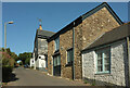
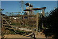
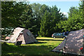
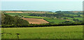
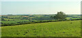
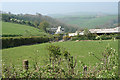
Photos of Blackawton & Stoke Fleming Ward


Area Information
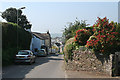
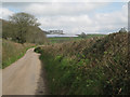
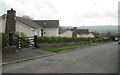
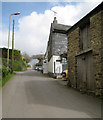
Living in Blackawton & Stoke Fleming Ward offers a distinctly rural experience within Devon's South West. You will find yourself in a district council ward that spans 47.3 km², encompassing the villages of Blackawton and Stoke Fleming. Blackawton sits approximately 4-6 miles west of Dartmouth and six miles south-west of Totnes. Stoke Fleming is a coastal settlement located just two miles from Dartmouth above Start Bay. The area's central coordinates place it firmly in the heart of South Devon's natural landscape. The local character is defined by working villages that maintain a gentle pace of life. You will encounter pretty surroundings with friendly residents and gorgeous countryside walks featuring sea and moor views. Blackawton feels like a communal hub where facilities are run by volunteers. Stoke Fleming presents a different scene with its proximity to the coast and access to Blackpool Sands beach. The village features historic pubs like The Green Dragon Inn and the Trattoria Spaggia restaurant. History runs deep here. Blackawton was first recorded as Avetona in the Domesday Book of 1086. It began as a farming community with specific villagers, smallholders, and ploughs mentioned in the record. Archaeological evidence suggests pre-Christian habitation with flint scatters and burial mounds. You can step back in time while enjoying modern amenities. Nearby landmarks include the 15th-century Church of St Michael in Blackawton and the 13th-century St Peter's Church in Stoke Fleming. This ward provides a balanced mix of heritage and natural beauty for those seeking a slower lifestyle.
- Area Type
- District Borough Unitary Ward
- Area Size
- 47.3 km²
- Population
- Not available
- Population Density
- Not available
Demographics
The demographic profile of Blackawton & Stoke Fleming Ward reflects its rural nature and connection to tourism and agriculture. The ward functions primarily as a residential location for locals who work in the surrounding Devon towns or remote sectors. While the data does not provide specific population counts or individual age breakdowns, the ward's character suggests a community where long-term residents mix with seasonal visitors. The village of Blackawton hosts an annual worm charming festival, indicating active local traditions and social cohesion. Households in this area typically consist of families or smaller groups attracted to the countryside living. The presence of volunteer-run facilities in Blackawton points to a tightly knit community where residents actively participate in village life. Stoke Fleming's coastal location draws people seeking holiday homes or retirement properties, potentially creating a slightly older average age compared to urban centres. The two villages operate somewhat independently yet share the broader ward identity within the South Hams District Council. Accommodation types are likely varied, ranging from historic properties with Norman features to modern rural builds. Blackawton's history as a farming community means many homes may be adapted from agricultural buildings. Stoke Fleming offers properties with sea views, appealing to buyers who prioritise scenic qualities over urban convenience. The demographic mix supports a stable, low-turnover environment where neighbours know one another. Deprivation levels are not highlighted, suggesting the area avoids significant economic disparity issues often found in dense urban wards. Residents enjoy a quality of life driven by natural assets and community spirit rather than commercial density.
Household Size
Accommodation Type
Tenure
Ethnic Group
Religion
Household Composition
Age
Household Deprivation
NS-SEC
Explore more demographic insights in this area
Go to Demographics tabPlanning
Planning Constraints
- Flood RiskPremium
- Ramsar Wetland SitesPremium
- Area of Outstanding Natural BeautyPremium
- Protected WoodlandPremium
- Crime RiskPremium