Area Overview for BH9 1YP
Photos of BH9 1YP


Area Information
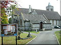
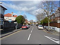
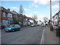
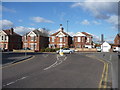
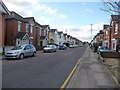
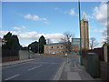
Living in BH9 1YP, a small residential cluster in Bournemouth, offers a blend of historical charm and modern convenience. With a population of 1,908, this area lies north of central Bournemouth, bordered by Winton to the south and Charminster to the east. Its roots trace back to the Bronze Age, with evidence of ancient settlements and 19th-century developments like the Mayfield Park Estate. The area’s compact size fosters a close-knit community, while its proximity to amenities such as Winton County First School, rail stations, and ferry landings ensures practicality for daily life. Residents benefit from easy access to Bournemouth’s town centre, major roads like Wimborne Road, and nearby attractions like Tuckton Tea Gardens. The mix of historic landmarks, such as St John’s Church, and 20th-century architecture creates a distinctive character that appeals to those seeking both heritage and accessibility.
- Area Type
- Postcode
- Area Size
- Not available
- Population
- Not available
- Population Density
- Not available
The property market in BH9 1YP is defined by a 49% home ownership rate, with houses forming the primary accommodation type. This suggests a mix of owner-occupied homes and rental properties, though the relatively small population of 1,908 implies a limited housing stock. The prevalence of houses, as opposed to flats, indicates a focus on family homes and semi-detached or detached properties. For buyers, this means a niche market with limited scope for expansion, requiring attention to nearby areas for broader options. The area’s compact size and proximity to Bournemouth’s infrastructure may make it attractive for those prioritising convenience over property choice, though competition for available homes could be fierce.
House Prices in BH9 1YP
No properties found in this postcode.
Energy Efficiency in BH9 1YP
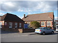
The lifestyle in BH9 1YP is shaped by its proximity to a range of amenities. Retail options include Tesco Moordown, Sainsburys Winton, and Co-op Moordown, ensuring everyday shopping needs are met. Rail stations like Bournemouth and Pokesdown offer easy access to the town centre and beyond, while ferry landings at Tuckton Tea Gardens and Christchurch Quay connect residents to coastal attractions. The area’s historical landmarks, such as St John’s Church and the Mayfield Park Estate, add cultural depth. With its mix of practical retail, transport links, and scenic routes, BH9 1YP balances convenience with the charm of its surroundings.
Amenities
Schools
The nearest school to BH9 1YP is Winton County First School, a primary institution serving the local community. While no Ofsted rating is provided, the presence of a primary school ensures immediate access to education for younger residents. Families requiring secondary schooling may need to consider nearby areas, as no secondary schools are listed in the data. The availability of a primary school aligns with the area’s demographic profile, which includes a significant proportion of adults in their 30s and 40s, likely with children in primary education. This makes BH9 1YP a viable option for families prioritising proximity to schooling.
| Rank | School | Type | Entry gender | Ages |
|---|---|---|---|---|
| 1 | Winton County First School | primary | N/A | N/A |
Explore more schools in this area
Go to Schools tabDemographics
The community in BH9 1YP is predominantly composed of adults aged 30–64, with a median age of 47. Home ownership stands at 49%, reflecting a moderate balance between owner-occupied properties and rental homes. The area is characterised by a predominance of houses, suggesting a focus on family-friendly living. The White ethnic group constitutes the majority, though specific diversity figures are not provided. The age profile indicates a mature population, likely with established careers and families. While no deprivation data is explicitly stated, the low crime risk score of 68/100 suggests a relatively stable environment. This demographic profile may appeal to professionals seeking a settled, low-maintenance lifestyle with access to local amenities.
Household Size
Accommodation Type
Tenure
Ethnic Group
Religion
Household Composition
Age
Household Deprivation
NS-SEC
Explore more demographic insights in this area
Go to Demographics tabPlanning
Planning Constraints
- Flood RiskPremium
- Ramsar Wetland SitesPremium
- Area of Outstanding Natural BeautyPremium
- Protected Nature ReservePremium
- Protected WoodlandPremium
- Crime RiskPremium