Area Overview for BH9 1SD
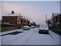
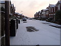
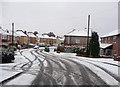
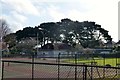
Photos of BH9 1SD


Area Information
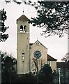
Living in BH9 1SD offers a quiet residential existence within the Bournemouth, Christchurch and Poole unitary authority. This specific postcode cluster supports a population of 1,712 residents, creating a tightly knit community rather than a sprawling urban block. The area sits north of central Bournemouth, bordered by Winton to the south and Charminster to the east. Historical records show this land was part of the Manor of Christchurch until the late 17th century before significant changes arrived with the 1805 Westover Enclosure Act. This act parcelled heathland into fields and established roads like Wimborne Road, which remains a key boundary following the area's incorporation into Bournemouth borough in 1901. Modern development includes the Mayfield Park Estate built around 1911 and the Grand Parade shop parades established in 1924. Today, the landscape blends historical charm with suburban convenience. You will find St John's Church at the junction of Vicarage and Wimborne Roads, a landmark relocated to its current site in 1874 after originally opening as a school chapel in 1853. The area feels established and grounded, lacking the frenetic pace of the town centre while maintaining easy links to surrounding districts. It is a place where history is visible in bricks and mortar rather than just local legends.
- Area Type
- Postcode
- Area Size
- Not available
- Population
- Not available
- Population Density
- Not available
The property market in BH9 1SD is overwhelmingly characterised by owner-occupied stock. With 80 per cent home ownership, the area is distinctly separate from the rental markets found in nearby university towns or student hubs. The accommodation type is exclusively houses, meaning you will not see blocks of flats or converted apartments dominating the streets around this postcode. This housing stock serves families and individuals who have chosen to buy rather than rent, often due to the specific desire for a standalone property within a suburban setting. For buyers looking at this location, the market reflects a community where residents are settled and less likely to move frequently. The absence of high-density housing suggests a layout of detached or semi-detached homes, typical of the Mayfield Park Estate developments from the early 20th century. This creates a property market driven by local demand rather than investment speculation. If you are considering homes in BH9 1SD, you are entering a sphere where the roof is generally yours. The prevalence of houses supports a market where extensions, gardens, and long-term improvements are common. This contrasts sharply with areas dominated by social housing or private rental schemes. The consistency in housing type means buyers know exactly what estates look like, removing uncertainty from the viewing process. You are purchasing a slice of a stable, owner-occupied community.
House Prices in BH9 1SD
No properties found in this postcode.
Energy Efficiency in BH9 1SD
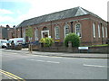
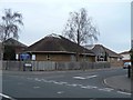
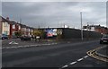
Daily life in BH9 1SD is underpinned by a network of amenities located within practical reach of residents. Supermarkets and retail options include Asda Charminster, the Co-op Charminster, and the Tesco Moordown, ensuring you can stock your home without long journeys. For those who enjoy the outdoors, Christchurch Quay Ferry Landing and Wick Christchurch Ferry Landing provide access to the water, while the Tuckton Tea Gardens Ferry Landing offers another coastal route. Educationally, the area is rooted in institutions like St John's Moordown, which was consecrated in 1874 and stands as a testament to the community's growth. Historical parades of shops such as Grand Parade and the art deco Mayfield Park Buildings from 1933 line Wimborne Road, giving the district a commercial character that predates modern retail parks. Local leisure spots include Charminster Farm and former sites like Burt's Farm, which once served as Moordown Farm. The area feels connected to the wider county, with main roads linking to larger towns. You will find that your daily errands, from grocery shopping to airport travel via Bournemouth Airport, are handled with ease. The mix of historical shop fronts and modern supermarkets ensures the area does not feel isolated despite its suburban nature.
Amenities
Schools
| Rank | School | Type | Entry gender | Ages |
|---|
Explore more schools in this area
Go to Schools tabDemographics
The community in BH9 1SD is defined by a mature population with a median age of 47 years. Most residents fall into the 30 to 64-year-old range, suggesting a neighbourhood where children have largely grown up and mortgages may be paid off. Home ownership stands at an impressive 80 per cent, indicating that the vast majority of people living here own their homes outright or with a significant equity buffer. This high rate of ownership correlates with the predominant accommodation type, which consists of houses rather than flats or apartments. The demographic profile points to a stable resident base likely invested in the long-term prosperity of the street. The predominant ethnic group in this area is White, reflecting the broader historical development patterns of the suburb since its inclusion in the Bournemouth borough. You are looking at a neighbourhood where neighbours have likely known each other for decades, fostering a sense of continuity. The age profile means you are joining a community accustomed to established local schools and mature public spaces. There is a distinct lack of transient housing or student accommodation, which stabilises the social fabric. This demographic stability usually translates to predictable property values and a neighbourly atmosphere where long-term residents care deeply for their immediate environment.
Household Size
Accommodation Type
Tenure
Ethnic Group
Religion
Household Composition
Age
Household Deprivation
NS-SEC
Explore more demographic insights in this area
Go to Demographics tabPlanning
Planning Constraints
- Flood RiskPremium
- Ramsar Wetland SitesPremium
- Area of Outstanding Natural BeautyPremium
- Protected Nature ReservePremium
- Protected WoodlandPremium