Area Overview for BH22 9RG
Photos of BH22 9RG
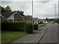
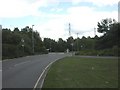
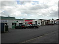

17 photos from this area
Area Information
Key information about the BH22 9RG including its size, population, and administrative classification.
- Area Type
- Postcode
- Area Size
- 3106 m²
- Population
- Not available
- Population Density
- Not available
House Prices in BH22 9RG
9
Properties
£283,500
Average Sold Price
£180,000
Lowest Price
£375,000
Highest Price
Showing 9 properties
| Address | Type | Beds | Baths | Last Sale Price | Last Sale Date | |
|---|---|---|---|---|---|---|
| 155 Leeson Drive, Ferndown, BH22 9RG | Detached | 2 | 1 | £324,000 | Mar 2025 | |
| 149 Leeson Drive, Ferndown, BH22 9RG | Semi-detached | 3 | 1 | £335,000 | Dec 2024 | |
| 151 Leeson Drive, Ferndown, BH22 9RG | Semi-detached | 3 | 1 | £375,000 | Aug 2024 | |
| 157 Leeson Drive, Ferndown, BH22 9RG | house | 3 | - | £315,000 | Jun 2021 | |
| 159 Leeson Drive, Ferndown, BH22 9RG | house | 3 | 1 | £262,500 | Jul 2019 | |
| 153 Leeson Drive, Ferndown, BH22 9RG | house | 2 | - | £180,000 | May 2012 | |
| 145 Leeson Drive, Ferndown, BH22 9RG | house | - | - | £193,000 | Mar 2010 | |
| 147 Leeson Drive, Ferndown, BH22 9RG | house | 3 | - | - | - | |
| 161 Leeson Drive, Ferndown, BH22 9RG | Detached | - | - | - | - |
Energy Efficiency in BH22 9RG
Amenities
Schools
| Rank | School | Type | Entry gender | Ages |
|---|
Explore more schools in this area
Go to Schools tabDemographics
Household Size
Two person
most common
Accommodation Type
Houses
most common
Tenure
81
majority
Ethnic Group
White
most common
Religion
N/A
most common
Household Composition
N/A
most common
Age
47
median
Adults (30-64 years)
most common
Household Deprivation
N/A
with no deprivation
NS-SEC
32
in Lower managerial occupations
Explore more demographic insights in this area
Go to Demographics tabPlanning
Planning Constraints
- Flood RiskPremium
- Ramsar Wetland SitesPremium
- Area of Outstanding Natural BeautyPremium
- Protected Nature ReservePremium
- Protected WoodlandPremium