Area Overview for BH21 6FB
Photos of BH21 6FB


Area Information
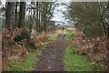
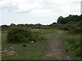
BH21 6FB represents a specific residential cluster within the village of West Moors, situated on the northern fringe of the Poole-Bournemouth conurbation. This postcode covers an area of 20.3 hectares, home to a population of 1,315 people. Life here is defined by the village's location approximately 10 miles from Bournemouth and 100 miles southwest of London. The settlement transitioned from a sparse heathland hamlet known as La More to a recognised suburban community following the arrival of the railway in 1847. A station followed in 1866, helping to drive expansion that turned the settlement into a commuter hub by the early 20th century. Residents today enjoy living in West Moors while benefiting from proximity to areas of outstanding natural beauty, including the Jurassic Coast and the New Forest National Park. The village functions as a residential community with a commercial village centre, providing everything needed for daily life within the parish. You can walk along the Castleman Trailway footpath, which follows the original railway trackbed connecting Ringwood to the east and Poole to the west. The area also hosts the Defence School of Petroleum and the Dorset and Wiltshire Fire and Rescue Service Training Centre, remnants of the significant military presence established after the Second World War. Recent population growth has been driven by commuters working in larger nearby centres rather than solely by local employment.
- Area Type
- Postcode
- Area Size
- 20.3 hectares
- Population
- 1315
- Population Density
- 332 people/km²
Homes in BH21 6FB are overwhelmingly occupied by people who own their property. The data shows that 80% of the area is owner-occupied, meaning that dealing with landlords or tenancy agreements is not a concern for the vast majority of residents. This high level of ownership points to a market characterised by long-term settlement rather than transient renting. Accommodation in this postcode consists largely of houses, which suits the established nature of the village and the preferences of the local demographic. For buyers looking at this small area and its immediate surroundings, the implication is a stock of established dwellings rather than new builds or apartment blocks. With a population of only 1,315 spread across 20.3 hectares, the housing supply is naturally limited, which can influence pricing dynamics compared to larger neighbouring postcodes. The society here is built around families and homeowners who have chosen West Moors for its balance of village life and commuter convenience. If you are considering purchasing a property, you enter a market defined by stability. The rapid population growth driven by commuters to Bournemouth, Poole, and London has increased demand for this type of housing. Consequently, the availability of homes for sale may be competitive, reflecting the shift from a sparse hamlet to a sought-after suburban settlement within the Dorset conurbation.
House Prices in BH21 6FB
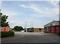
Showing 7 properties
| Address | Type | Beds | Baths | Last Sale Price | Last Sale Date | |
|---|---|---|---|---|---|---|
| 1A Thorne Way, Three Legged Cross, BH21 6FB | Industrial | - | - | - | - | |
| 1B Thorne Way, Three Legged Cross, BH21 6FB | Industrial | - | - | - | - | |
| Culture Motorcycles Ltd, 4-5 Thorne Way, Three Legged Cross, BH21 6FB | office_workshop | - | - | - | - | |
| 26-28 Thorne Way, Three Legged Cross, BH21 6FB | office_workshop | - | - | - | - | |
| 7-9 Thorne Way, Three Legged Cross, BH21 6FB | warehouse | - | - | - | - | |
| Direct Materials Supplies Enviro Ltd, 22-24 Thorne Way, Three Legged Cross, BH21 6FB | Office | - | - | - | - | |
| Ford Civil Engineering Ltd, 1 Thorne Way, Three Legged Cross, BH21 6FB | office_workshop | - | - | - | - |
Energy Efficiency in BH21 6FB
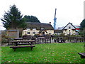
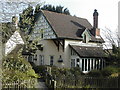
Life in BH21 6FB centres on a commercial village centre surrounded by green spaces and historical landmarks. Residents within this 20.3-hectare cluster have five key retail amenities in practical reach. You can visit Spar for daily essentials, Tesco West for groceries, or M&S St Leonards BP if you are looking for curved cuts of meat at the service station. These shops form the heart of the village's commercial activity, which developed significantly in the early 1900s following post-railway expansion. Beyond retail, the area offers excellent connectivity to leisure and travel facilities. There are two airports nearby: Bournemouth Airport and Bournemouth International Airport, providing easy access to national travel networks. The village retains the original level crossing gatekeeper's cottage on Station Road, a historic remnant that adds character to the streets. You can explore the area on foot using the Castleman Trailway footpath, which allows you to connect Ringwood to the east and Poole to the west. The Military Fuel Depot remains a notable feature, housing the Dorset and Wiltshire Fire and Rescue Service Training Centre. This blend of shopping, historic architecture, and open pathways defines the lifestyle here. It is a location where you have immediate access to necessities while enjoying the proximity to the Jurassic Coast and Purbeck Hills through the wider parish of West Moors.
Amenities
Schools
Families living in BH21 6FB have access to two primary schools in the vicinity. The first is West Moors, St Mary's Church of England Voluntary Controlled First School, which operates as a voluntary controlled institution. Nearby is St Mary's CofE First School and Nursery, which functions as an academy. Both institutions provide education for young children within the parish, allowing residents to keep their homes and schooling local. Your children can attend one of these Church of England schools, which align with the village's history, including the St Mary the Virgin parish church constructed in 1896. Because both listed facilities are first schools, they cater specifically to younger pupils, typically aged four to seven. This arrangement means older children will likely need to travel to larger high schools in neighbouring Ferndown or Verwood, even though your home in BH21 6FB offers a convenient start to their educational journey. The mix of voluntary controlled and academy types indicates a blend of traditional community governance and modern educational structures. You do not have to look far for early education; the schools are clustered around the village centre where you would also find the trading store and village hall.
| Rank | School | Type | Entry gender | Ages |
|---|
Explore more schools in this area
Go to Schools tabDemographics
The community in BH21 6FB is mature and established. The median age in this postcode is 47, with the most common age range being adults between 30 and 64 years old. This profile suggests a family-friendly environment suited to professionals and those in the middle stages of their careers. Home ownership is extensive, with 80% of residents owning their homes outright or with a mortgage. This figure indicates a stable, settled population that has put down deep roots in the village. The predominant ethnic group is White, reflecting the typical demographic makeup of many rural Dorset settlements. Accommodation types in this small cluster consist primarily of houses, aligning with the village's historic character and suburban expansion. This housing stock supports the high home ownership rate, as there is a limited incentive for the 20% who do not own to remain due to a lack of rental stock in this specific cluster. The low population density of 332 people per square kilometre contributes to a quieter living environment compared to denser urban suburbs. You will find a neighbourhood where stability is the norm, with long-term residents forming the backbone of the local community. This demographic makes sense for those seeking a quiet life away from the city centre while maintaining easy access to the wider Bournemouth area for work and leisure.
Household Size
Accommodation Type
Tenure
Ethnic Group
Religion
Household Composition
Age
Household Deprivation
NS-SEC
Explore more demographic insights in this area
Go to Demographics tabPlanning
Planning Constraints
- Flood RiskPremium
- Ramsar Wetland SitesPremium
- Area of Outstanding Natural BeautyPremium
- Protected Nature ReservePremium
- Protected WoodlandPremium