Area Overview for BH21 2SS
Photos of BH21 2SS
Area Information
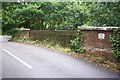
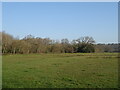
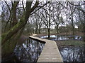
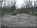
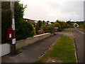
BH21 2SS is a small, tightly knit residential postcode area in south-east Dorset, encompassing parts of the semi-rural village of Colehill. With a population of 1,246 spread across 7,119 square metres, the area has a high population density of 909 people per square kilometre, reflecting its compact, clustered nature. Colehill itself is a village with a long history, dating back to the 1430s, and has evolved from a medieval hamlet into a semi-rural community with suburban elements. Recent developments, such as new housing along Cranborne Road and Leigh Road, have expanded its footprint while maintaining its village character. The area is defined by well-wooded landscapes, common land, and a strong sense of community, reinforced by its village green status at Triangle Woods. Residents benefit from proximity to Wimborne Minster and the A31, offering easy access to nearby towns and amenities. Daily life here blends rural tranquillity with practical connectivity, making it appealing to those seeking a balanced lifestyle.
- Area Type
- Postcode
- Area Size
- 7119 m²
- Population
- 1246
- Population Density
- 909 people/km²
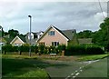
The property market in BH21 2SS is dominated by owner-occupied homes, with 92% of properties owned outright. This high rate of homeownership indicates a stable, long-term resident base and limited rental activity, which is typical of semi-rural areas where property values are less influenced by transient demand. The accommodation type is predominantly houses, reflecting the area’s low-density, semi-rural setting. This contrasts with urban centres where flats or terraced housing are more common. For buyers, this means a market focused on family homes and established properties, with limited scope for speculative investment. The small size of the area and its proximity to Wimborne Minster suggest that property values may be influenced by local amenities and transport links, though specific price data is not available. The focus on houses also implies that buyers seeking larger, more private properties may find this area particularly appealing.
House Prices in BH21 2SS
Showing 1 properties
| Address | Type | Beds | Baths | Last Sale Price | Last Sale Date | |
|---|---|---|---|---|---|---|
| Beaucroft School, Wimborne Road, Colehill, BH21 2SS | education | - | - | - | - |
Energy Efficiency in BH21 2SS
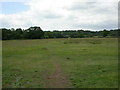
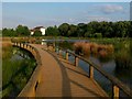
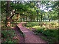
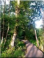
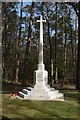
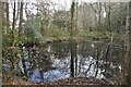
The lifestyle in BH21 2SS is shaped by its semi-rural setting and proximity to local amenities. Within practical reach are five retail venues, including Co-op Colehill, Spar Gordon, and M&S Minster BP, offering everyday shopping needs. The area’s rail network, with stations like Parkstone and Branksome, connects residents to Bournemouth and surrounding areas, while Bournemouth Airport provides regional travel options. Recreational opportunities include Triangle Woods, a village green with a war memorial, and Leigh Common Local Nature Reserve, ideal for walking or leisure. The Forestry England plantation at Cannon Hill adds to the outdoor appeal, offering trails for walking and mountain biking. The blend of green spaces, retail, and transport links creates a convenient, balanced lifestyle, appealing to those who value both tranquillity and accessibility.
Amenities
Schools
The schools near BH21 2SS include St Michael’s Church of England Voluntary Aided Middle School in Colehill, a primary school serving the local community. Beaucroft Foundation School is a special school, catering to students with specific educational needs, while St Michael’s Church of England Middle School, also in Colehill, is an academy with a good Ofsted rating. This mix of school types ensures a range of educational options for families, from mainstream primary education to specialist provision. The presence of an Ofsted-rated good academy suggests a strong local school offering, which may be a key consideration for families prioritising quality education. However, the absence of secondary schools in the immediate area means parents may need to look further afield for high school options. The diversity of school types reflects the area’s commitment to inclusive education, though the exact catchment areas and pupil numbers are not detailed in the data.
| Rank | School | Type | Entry gender | Ages |
|---|
Explore more schools in this area
Go to Schools tabDemographics
The demographic profile of BH21 2SS reflects a mature, stable community. The median age is 47, with the majority of residents falling within the 30–64 age range, indicating a population skewed towards adults in their prime working years. Home ownership is exceptionally high at 92%, suggesting a strong local economy and long-term residency. The predominant accommodation type is houses, aligning with the area’s semi-rural character and lower density compared to urban centres. The predominant ethnic group is White, though specific data on diversity or deprivation is not provided. This age profile and high homeownership rate suggest a community with established families and a focus on long-term living. The absence of detailed diversity metrics means the area’s cultural composition remains less defined in the data, but the demographic stability points to a consistent, low-turnover population.
Household Size
Accommodation Type
Tenure
Ethnic Group
Religion
Household Composition
Age
Household Deprivation
NS-SEC
Explore more demographic insights in this area
Go to Demographics tabPlanning
Planning Constraints
- Flood RiskPremium
- Ramsar Wetland SitesPremium
- Area of Outstanding Natural BeautyPremium
- Protected Nature ReservePremium
- Protected WoodlandPremium