Area Overview for BH20 7HT
Photos of BH20 7HT
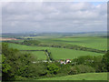
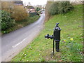
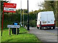
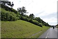
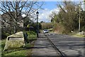
19 photos from this area
Area Information
Key information about the BH20 7HT including its size, population, and administrative classification.
- Area Type
- Postcode
- Area Size
- 1.0 hectares
- Population
- 1946
- Population Density
- 44 people/km²
House Prices in BH20 7HT
15
Properties
£274,389
Average Sold Price
£165,000
Lowest Price
£475,000
Highest Price
Showing 15 properties
| Address | Type | Beds | Baths | Last Sale Price | Last Sale Date | |
|---|---|---|---|---|---|---|
| 55 West Street, Bere Regis, BH20 7HT | Terraced | 2 | 1 | £324,500 | Nov 2025 | |
| 57 West Street, Bere Regis, BH20 7HT | house | - | - | £300,000 | Apr 2022 | |
| 59-60 West Street, Bere Regis, BH20 7HT | Semi-detached | 3 | 1 | £475,000 | Sep 2021 | |
| 52 West Street, Bere Regis, BH20 7HT | house | - | - | £390,000 | Oct 2017 | |
| 48 West Street, Bere Regis, BH20 7HT | house | 2 | - | £182,000 | Jun 2013 | |
| 58 West Street, Bere Regis, BH20 7HT | Terraced | 2 | 1 | £167,500 | Apr 2009 | |
| Rumbles, West Street, Bere Regis, BH20 7HT | Bungalow | - | - | £297,500 | Nov 2006 | |
| 50 West Street, Bere Regis, BH20 7HT | house | - | - | £165,000 | Jul 2004 | |
| 49 West Street, Bere Regis, BH20 7HT | Terraced | - | - | £168,000 | Dec 2003 | |
| 45 West Street, Bere Regis, BH20 7HT | Terraced | 3 | - | - | - |
Page 1 of 2
Energy Efficiency in BH20 7HT
Amenities
Schools
| Rank | School | Type | Entry gender | Ages |
|---|
Explore more schools in this area
Go to Schools tabDemographics
Household Size
Two person
most common
Accommodation Type
Houses
most common
Tenure
61
majority
Ethnic Group
White
most common
Religion
N/A
most common
Household Composition
N/A
most common
Age
47
median
Adults (30-64 years)
most common
Household Deprivation
N/A
with no deprivation
NS-SEC
36
in Lower managerial occupations
Explore more demographic insights in this area
Go to Demographics tabPlanning
Planning Constraints
- Flood RiskPremium
- Ramsar Wetland SitesPremium
- Area of Outstanding Natural BeautyPremium
- Protected Nature ReservePremium
- Protected WoodlandPremium