Area Overview for BH14 0EB
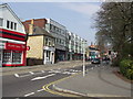
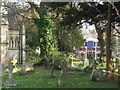
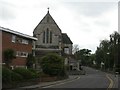
Photos of BH14 0EB


Area Information
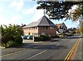
BH14 0EB is a compact residential postcode in Poole, England, covering just 381 square metres and home to 2085 people. Its high population density of over 5 million per square kilometre reflects its small, tightly packed nature. Situated in Parkstone, the area is split into Lower Parkstone, near Poole Harbour, and Upper Parkstone, on higher ground. This postcode falls within the Parkstone Ward, a historically significant area that was once a civil parish before merging with Poole in 1905. The area’s proximity to Poole Harbour, Bournemouth Airport, and multiple rail stations makes it a convenient base for those seeking coastal access and transport links. Daily life here is shaped by its mix of residential flats, small retail outlets, and ferry connections. With a median age of 47, the community is largely composed of adults in their 30s to 60s, suggesting a mature, stable demographic. The area’s blend of coastal charm and practical infrastructure offers a distinct lifestyle for those prioritising accessibility and a sense of place.
- Area Type
- Postcode
- Area Size
- 381 m²
- Population
- Not available
- Population Density
- Not available
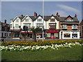
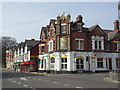
The property market in BH14 0EB is defined by its high proportion of flats, with 59% of residents owning their homes. This suggests a mix of owner-occupied and rental properties, though the exact split between these is not specified. The compact size of the area, at just 381 square metres, means housing stock is limited, and the immediate surroundings may offer similar options. Flats dominate, which is typical of areas with high population density and proximity to transport hubs. Buyers should consider the small scale of the area, as property availability is likely constrained. The presence of nearby rail stations, such as Parkstone and Poole, may enhance the appeal of flats for commuters. However, the lack of larger homes or detached properties indicates this is not a market for those seeking expansive living spaces. Prospective buyers should also note the area’s integration with Poole’s infrastructure, which could influence property values and desirability.
House Prices in BH14 0EB
No properties found in this postcode.
Energy Efficiency in BH14 0EB
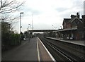
Living in BH14 0EB offers access to a range of practical amenities within close proximity. Retail options include Co-op Poole, Asda Highland New, and Spar Sandbanks, providing essential shopping for daily needs. The area’s ferry services, such as Poole Quay Ferry Landing and Brownsea Island Ferry Landing, connect residents to Poole Harbour and nearby islands, adding to the coastal lifestyle. Rail stations like Parkstone and Branksome offer easy access to Bournemouth and Poole, while Bournemouth Airport is nearby for regional travel. The presence of multiple retail and transport hubs ensures convenience for commuting, leisure, and errands. The compact nature of the area means amenities are tightly clustered, reducing the need for long journeys. This mix of retail, transport, and coastal access creates a lifestyle that balances practicality with proximity to natural and urban amenities.
Amenities
Schools
| Rank | School | Type | Entry gender | Ages |
|---|
Explore more schools in this area
Go to Schools tabDemographics
The population of BH14 0EB is predominantly adults aged 30–64, with a median age of 47. This suggests a community of established professionals and families. Home ownership is at 59%, meaning nearly six in ten residents own their properties, while the remaining 41% are likely renters. The area is characterised by flats, indicating a mix of purpose-built housing and converted properties. The predominant ethnic group is White, though no specific data on diversity or deprivation is provided. The age profile implies a stable, low-turnover population, which can contribute to a cohesive community feel. With no mention of social deprivation metrics, the area appears to support a quality of life aligned with its demographic profile. The concentration of adults in midlife may reflect a balance between career stability and family life, shaping local amenities and services around these needs.
Household Size
Accommodation Type
Tenure
Ethnic Group
Religion
Household Composition
Age
Household Deprivation
NS-SEC
Explore more demographic insights in this area
Go to Demographics tabPlanning
Planning Constraints
- Flood RiskPremium
- Ramsar Wetland SitesPremium
- Area of Outstanding Natural BeautyPremium
- Protected Nature ReservePremium
- Protected WoodlandPremium