Area Overview for BA22 8YP
Photos of BA22 8YP
Area Information
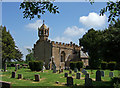
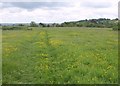
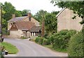
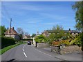
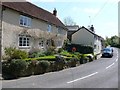
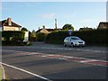
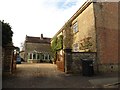
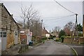
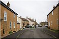
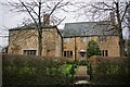
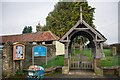
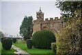
BA22 8YP is a small residential cluster in Somerset, England, encompassing the village of Chilthorne Domer. With a population of 1200 and a density of 78 people per square kilometre, it retains a rural character while offering proximity to nearby towns like Yeovil, just 4 miles to the south. The area is defined by its historic roots, with origins tracing back to the Domesday Book and a 17th-century manor house still standing. Residents benefit from a mix of traditional architecture, including the Grade II* listed Church of St Mary, and a community-focused environment. The postcode area is served by primary schools, local amenities, and transport links, making it suitable for families and those seeking a quieter, semi-rural lifestyle. Its location on the old coach road between Ilchester and Yeovil ensures connectivity without the congestion of larger urban centres.
- Area Type
- Postcode
- Area Size
- Not available
- Population
- 1200
- Population Density
- 78 people/km²
The property market in BA22 8YP is characterised by high home ownership (80%) and a focus on houses rather than flats or apartments. This suggests a predominantly owner-occupied area with limited rental activity, typical of rural or semi-rural locations. The housing stock is likely to include older properties, given the area’s historical significance, such as the 17th-century manor house. Buyers should expect a small, tightly knit market with limited new developments, as the area is a small parish. The scarcity of properties means demand may outstrip supply, particularly for homes with specific features like gardens or period details. For those seeking a long-term investment, the stability of the area and its low crime rates add to its appeal, though potential buyers should consider the limited scope for expansion or modernisation.
House Prices in BA22 8YP
No properties found in this postcode.
Energy Efficiency in BA22 8YP
The lifestyle in BA22 8YP is shaped by its proximity to local amenities, including five retail outlets such as Tesco Yeovil, Tesco Ilchester, and Co-op Westfield. These provide everyday shopping needs, while the nearby railway stations and RNAS Yeovilton offer transport options for travel or leisure. The area’s rural character is complemented by its historical sites, such as the Church of St Mary and Axesclose Farmhouse, which contribute to a sense of heritage. Residents can enjoy a slower pace of life, with access to both local services and the opportunity to explore nearby towns. The presence of multiple retail options and transport links ensures convenience without compromising the area’s quiet, semi-rural appeal.
Amenities
Schools
Residents of BA22 8YP have access to two primary schools within practical reach: Chilthorne Domer Church School and St Margaret’s School, Tintinhull. Both institutions hold an Ofsted rating of ‘good’, indicating a solid standard of education for children aged 4–11. The presence of two primary schools suggests a well-supported local education network, reducing the need for long commutes to secondary schools. Families with young children may benefit from the proximity of these schools, which are likely to foster a sense of community among parents and students. The ‘good’ ratings reflect satisfactory teaching quality and student outcomes, though parents may still seek additional enrichment opportunities beyond the primary level.
| Rank | School | Type | Entry gender | Ages |
|---|---|---|---|---|
| 1 | Chilthorne Domer Church School | primary | N/A | N/A |
| 2 | St Margaret's School, Tintinhull | primary | N/A | N/A |
Explore more schools in this area
Go to Schools tabDemographics
The population of BA22 8YP is predominantly middle-aged, with a median age of 47 and the most common age range being adults aged 30–64. Home ownership is high at 80%, reflecting a stable, long-term resident base. The accommodation type is primarily houses, indicating a low-density, family-oriented settlement. The predominant ethnic group is White, aligning with broader regional demographics. The area’s population density of 78 people per square kilometre suggests a spread-out, rural layout with ample private space. This profile implies a community where families are likely to stay for extended periods, contributing to a cohesive local identity. The absence of significant deprivation data means the area appears to support a reasonable quality of life, with services and infrastructure meeting basic needs.
Household Size
Accommodation Type
Tenure
Ethnic Group
Religion
Household Composition
Age
Household Deprivation
NS-SEC
Explore more demographic insights in this area
Go to Demographics tabPlanning
Planning Constraints
- Flood RiskPremium
- Ramsar Wetland SitesPremium
- Area of Outstanding Natural BeautyPremium
- Protected Nature ReservePremium
- Protected WoodlandPremium
- Crime RiskPremium