Area Overview for BA22 8DL
Photos of BA22 8DL


Area Information
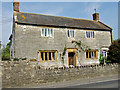
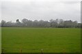
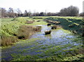
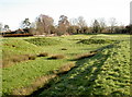
BA22 8DL is a small, tightly knit residential cluster in Somerset, covering just 2.3 hectares and home to 1,209 residents. Its population density of 68 people per square kilometre reflects a quiet, low-rise character typical of rural England. Nestled in Marston Magna, a village with Saxon roots, the area blends historical charm with modern convenience. The village’s name, derived from “marsh settlement,” hints at its past as a muddy, agricultural hub, though today it thrives as a picturesque community with a strong sense of tradition. Residents benefit from proximity to Yeovil, just 5 miles away, offering access to services and transport links. The area’s compact size means a close-knit community feel, with local events like the annual fête and Christmas market fostering neighbourly connections. While the postcode is small, it sits near RNAS Yeovilton, a military airfield, which may influence local character. For those seeking a peaceful, historic village with practical amenities, BA22 8DL offers a distinct blend of rural tranquillity and accessible infrastructure.
- Area Type
- Postcode
- Area Size
- 2.3 hectares
- Population
- 1209
- Population Density
- 68 people/km²
The property market in BA22 8DL is dominated by owner-occupied homes, with 82% of properties owned by residents rather than rented. The accommodation type is predominantly houses, which is unusual for a small postcode but aligns with the village’s traditional, low-density character. This suggests a market where properties are likely to be family homes, often with gardens and space, rather than apartments or terraced housing. Given the area’s small size—just 2.3 hectares—and population of 1,209, the housing stock is limited, meaning buyers may find fewer options compared to larger towns. However, the high home ownership rate indicates a stable market with long-term residents. Those considering purchase should note the compact nature of the area, which may limit availability but also reinforce a sense of community. Nearby towns like Yeovil offer more extensive property choices, though commuting distances may be a factor.
House Prices in BA22 8DL
Showing 1 properties
| Address | Type | Beds | Baths | Last Sale Price | Last Sale Date | |
|---|---|---|---|---|---|---|
| Brian Perry Waste Paper Ltd, Rimpton Road, Marston Magna, Yeovil, BA22 8DL | retail_financial | - | - | - | - |
Energy Efficiency in BA22 8DL
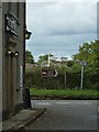
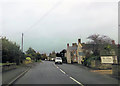
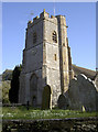
Life in BA22 8DL revolves around its small village core, with nearby amenities including shops like Tesco Cavalier, The Southern Co-operative, and Spar Simons, offering essentials within walking distance. The village hosts annual events such as a fête and Christmas market, fostering community spirit. For transport, four railway stations provide access to Yeovil and beyond, while the nearby RNAS Yeovilton airfield adds a unique backdrop. The area’s historical charm includes the Grade I listed Church of St Mary and medieval moat remnants, offering cultural and recreational interest. Despite its compact size, the village maintains a vibrant, active lifestyle through local businesses, community groups, and seasonal events. Residents benefit from a mix of rural tranquillity and practical access to services, making it ideal for those seeking a self-contained, historic environment with modern convenience.
Amenities
Schools
| Rank | School | Type | Entry gender | Ages |
|---|
Explore more schools in this area
Go to Schools tabDemographics
The population of BA22 8DL skews towards middle-aged adults, with a median age of 47 and the majority (30–64 years) in their prime working years. Home ownership is high, at 82%, indicating a stable, long-term resident base. The area is predominantly composed of houses rather than flats, reflecting a preference for traditional, family-oriented living. The predominant ethnic group is White, though specific data on diversity is not provided. With 1,209 residents spread across 2.3 hectares, the area maintains a low population density, contributing to a less crowded, more private lifestyle. The demographic profile suggests a community focused on stability and continuity, with fewer transient residents. This aligns with the village’s historical roots and its current role as a functioning, active local hub rather than a commuter suburb.
Household Size
Accommodation Type
Tenure
Ethnic Group
Religion
Household Composition
Age
Household Deprivation
NS-SEC
Explore more demographic insights in this area
Go to Demographics tabPlanning
Planning Constraints
- Flood RiskPremium
- Ramsar Wetland SitesPremium
- Area of Outstanding Natural BeautyPremium
- Protected Nature ReservePremium
- Protected WoodlandPremium