Area Overview for BA21 4FB
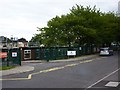
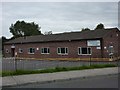
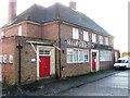
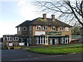
Photos of BA21 4FB


Area Information
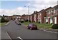
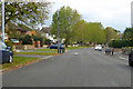
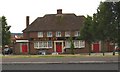
Living in BA21 4FB places you within a very compact residential cluster covering just 3,783 square metres in South West England. This specific postcode area sits in Yeovil, a historic market town in Somerset located approximately 126 miles west of London. The site defined by this postcode is tiny, containing a population of 1,755 residents who live in a dense setting that matches a population density of 463,933 people per square kilometre. Such high figures reflect the concentrated nature of the site rather than the wider town. Yeovil itself traces its roots back to around 880, first mentioned as Gifle in historical records and appearing in the Domesday Book of 1086 as Givele. The town centre focal point is the Anglo-Saxon minster church of St John the Baptist, though this original building was demolished and replaced by later expansions. Other historical landmarks include the Hundred Stone used for court meetings and the Hound Stone in Thorne Lane. Residents today inherit a community shaped by centuries of evolution, including periods of significant population decline during the Black Death and destruction by fires in the 15th and 17th centuries. The area retains status as an ancient parish within the Stone Hundred, offering a neighbourhood defined by deep local history and a tightly knit physical footprint.
- Area Type
- Postcode
- Area Size
- 3783 m²
- Population
- 1755
- Population Density
- 6073 people/km²
The property landscape in BA21 4FB is characterised by a predominance of houses rather than flats or high-density apartment blocks. This housing stock suits the prevailing demographic of adults between 30 and 64 years old, who often require more space than transient urban dwellers. Approximately 43% of households within the postcode are owner-occupied, suggesting a market where stability and long-term residence value are important factors. This statistic indicates that the area functions less as a speculative rental hub and more as a community where residents put down roots. Given the total area size of just 3,783 square metres, the housing stock is intensely concentrated. Prospective buyers looking for homes in BA21 4FB should expect a environment dominated by private residences. The mix of ownership implies a community with diverse financial capabilities, balancing homeowners seeking equity growth with those renting nearby. The fact that the vast majority of ends are houses means you are unlikely to find modern micro-apartments or large multiple-unit developments typical of city centres. Instead, the market reflects the historic layout of Yeovil, where property values are anchored by the enduring nature of the house stock and the stability of the surrounding neighbourhood.
House Prices in BA21 4FB
Showing 9 properties
| Address | Type | Beds | Baths | Last Sale Price | Last Sale Date | |
|---|---|---|---|---|---|---|
| 2, The Old Inn, 85 Milford Road, Yeovil, BA21 4FB | Bungalow | - | - | - | - | |
| 6, The Old Inn, 85 Milford Road, Yeovil, BA21 4FB | Flat | - | - | - | - | |
| 7, The Old Inn, 85 Milford Road, Yeovil, BA21 4FB | Flat | - | - | - | - | |
| 3, The Old Inn, 85 Milford Road, Yeovil, BA21 4FB | Bungalow | - | - | - | - | |
| 1, The Old Inn, 85 Milford Road, Yeovil, BA21 4FB | Bungalow | - | - | - | - | |
| 8, The Old Inn, 85 Milford Road, Yeovil, BA21 4FB | Flat | - | - | - | - | |
| 4, The Old Inn, 85 Milford Road, Yeovil, BA21 4FB | Flat | - | - | - | - | |
| 5, The Old Inn, 85 Milford Road, Yeovil, BA21 4FB | Flat | - | - | - | - | |
| 9, The Old Inn, 85 Milford Road, Yeovil, BA21 4FB | Flat | - | - | - | - |
Energy Efficiency in BA21 4FB
Daily life in BA21 4FB benefits from its location as the heart of a historic town with established amenities within practical reach. Retail options include Co-op Yeovil, Morrisons Daily, and The Southern Co-operative Co-op. These three venues provide essential shopping needs close to where you live. Residents also have access to five railway stations nearby, including Yeovil Pen Mill Railway Station, Yeovil Junction Railway Station, and Thornford Railway Station. Having five rail links offers flexibility for commuters travelling to London or other parts of the South West. These stations span different parts of the town network, allowing you to choose a route that fits your schedule. For urgent travel or leisure trips, RNAS Yeovilton serves as the nearest airport, though it functions primarily as a Royal Navy air station. The presence of these facilities means you do not need a car for every minor journey. Shopping for groceries, banking, and catching trains are achievable on foot or by short car rides from the postcode. This concentration of services supports a lifestyle that balances convenience with the quieter atmosphere of a residential post-war cluster.
Amenities
Schools
| Rank | School | Type | Entry gender | Ages |
|---|
Explore more schools in this area
Go to Schools tabDemographics
The community profile for BA21 4FB reveals a significantly mature demographic. The median age across this area sits at 47 years, with the majority of the population falling into the 30-64 age range. This concentration of adults suggests the neighbourhood appeals to families, empty nesters, and long-term residents rather than a transient student or young professional cohort. Home ownership figures show that 43% of households own their property outright or with a mortgage, indicating a mixed tenure environment where nearly half the residents are holders rather than renters. The predominant accommodation type consists of houses, which aligns with the family-oriented age profile. The ethnic makeup is predominantly White, reflecting the traditional character of older South West England communities. With a median age of 47, the likely residents are those who have settled in the region, possibly having raised children locally or chosen the area for its slower pace. The small population size of 1,755 means social connections here are likely established and enduring. Residents do not face the volatility of rapidly shifting demographics seen in student towns.
Household Size
Accommodation Type
Tenure
Ethnic Group
Religion
Household Composition
Age
Household Deprivation
NS-SEC
Explore more demographic insights in this area
Go to Demographics tabPlanning
Planning Constraints
- Flood RiskPremium
- Ramsar Wetland SitesPremium
- Area of Outstanding Natural BeautyPremium
- Protected Nature ReservePremium
- Protected WoodlandPremium