Area Overview for BA2 9JB
Photos of BA2 9JB
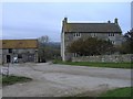
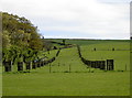
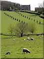
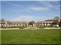

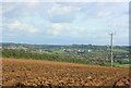
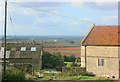
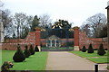
17 photos from this area
Area Information
Key information about the BA2 9JB including its size, population, and administrative classification.
- Area Type
- Postcode
- Area Size
- 2.5 km²
- Population
- 2326
- Population Density
- 118 people/km²
House Prices in BA2 9JB
10
Properties
£348,750
Average Sold Price
£65,000
Lowest Price
£840,000
Highest Price
Showing 10 properties
| Address | Type | Beds | Baths | Last Sale Price | Last Sale Date | |
|---|---|---|---|---|---|---|
| 6, Wilmington, Colliers Lane, Newton St Loe, Bath, BA2 9JB | Detached | 1 | 1 | £840,000 | Jan 2017 | |
| 1, Wilmington, Colliers Lane, Newton St Loe, Bath, BA2 9JB | Detached | 3 | - | £410,000 | Mar 2014 | |
| 3, Wilmington, Colliers Lane, Newton St Loe, Bath, BA2 9JB | Semi-detached | - | - | £65,000 | Jun 1996 | |
| 4, Wilmington, Colliers Lane, Newton St Loe, Bath, BA2 9JB | house | - | - | £80,000 | Nov 1995 | |
| Wilmington Farm, Colliers Lane, Newton St Loe, Bath, BA2 9JB | Bungalow | 5 | - | - | - | |
| The Old Kitchen, Wilmington Farm, Colliers Lane, Newton St Loe, Bath, BA2 9JB | Flat | - | - | - | - | |
| 2, Wilmington, Colliers Lane, Newton St Loe, Bath, BA2 9JB | Semi-detached | - | - | - | - | |
| Lambing Pen, Wilmington, Colliers Lane, Newton St Loe, Bath, BA2 9JB | Bungalow | - | - | - | - | |
| 5, Wilmington, Colliers Lane, Newton St Loe, Bath, BA2 9JB | house | - | - | - | - | |
| 8-9, Wilmington, Colliers Lane, Newton St Loe, Bath, BA2 9JB | Semi-detached | - | - | - | - |
Energy Efficiency in BA2 9JB
Amenities
Schools
| Rank | School | Type | Entry gender | Ages |
|---|
Explore more schools in this area
Go to Schools tabDemographics
Household Size
Two person
most common
Accommodation Type
Houses
most common
Tenure
67
majority
Ethnic Group
White
most common
Religion
N/A
most common
Household Composition
N/A
most common
Age
22
median
Young Adults (15-29 years)
most common
Household Deprivation
N/A
with no deprivation
NS-SEC
17
in Lower managerial occupations
Explore more demographic insights in this area
Go to Demographics tabPlanning
Planning Constraints
- Flood RiskPremium
- Ramsar Wetland SitesPremium
- Area of Outstanding Natural BeautyPremium
- Protected Nature ReservePremium
- Protected WoodlandPremium