Area Overview for BA2 6UR
Photos of BA2 6UR
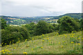

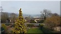
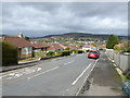
39 photos from this area
Area Information
Key information about the BA2 6UR including its size, population, and administrative classification.
- Area Type
- Postcode
- Area Size
- 1.4 hectares
- Population
- 1476
- Population Density
- 290 people/km²
House Prices in BA2 6UR
22
Properties
£327,500
Average Sold Price
£89,000
Lowest Price
£499,500
Highest Price
Showing 22 properties
| Address | Type | Beds | Baths | Last Sale Price | Last Sale Date | |
|---|---|---|---|---|---|---|
| 111 Holcombe Close, Bathampton, Bath, BA2 6UR | Bungalow | - | - | £418,000 | Apr 2021 | |
| 87 Holcombe Close, Bathampton, Bath, BA2 6UR | Bungalow | 2 | 1 | £390,000 | Feb 2021 | |
| 89 Holcombe Close, Bathampton, Bath, BA2 6UR | Semi-detached | 2 | 1 | £330,000 | Sep 2019 | |
| 169 Holcombe Close, Bathampton, Bath, BA2 6UR | Semi-detached | 2 | 1 | £371,500 | Sep 2019 | |
| 99 Holcombe Close, Bathampton, Bath, BA2 6UR | Semi-detached | 2 | 1 | £317,000 | Aug 2019 | |
| 113 Holcombe Close, Bathampton, Bath, BA2 6UR | Semi-detached | 4 | 1 | £395,000 | Jun 2019 | |
| 105 Holcombe Close, Bathampton, Bath, BA2 6UR | Bungalow | 3 | 1 | £300,000 | May 2017 | |
| 167 Holcombe Close, Bathampton, Bath, BA2 6UR | Bungalow | - | - | £499,500 | Dec 2016 | |
| 107 Holcombe Close, Bathampton, Bath, BA2 6UR | Semi-detached | 2 | - | £380,000 | Nov 2016 | |
| 109 Holcombe Close, Bathampton, Bath, BA2 6UR | Semi-detached | 3 | - | £370,000 | Mar 2016 |
Page 1 of 3
Energy Efficiency in BA2 6UR
Amenities
Schools
| Rank | School | Type | Entry gender | Ages |
|---|
Explore more schools in this area
Go to Schools tabDemographics
Household Size
Two person
most common
Accommodation Type
Houses
most common
Tenure
87
majority
Ethnic Group
White
most common
Religion
N/A
most common
Household Composition
N/A
most common
Age
47
median
Adults (30-64 years)
most common
Household Deprivation
N/A
with no deprivation
NS-SEC
55
in Lower managerial occupations
Explore more demographic insights in this area
Go to Demographics tabPlanning
Planning Constraints
- Flood RiskPremium
- Ramsar Wetland SitesPremium
- Area of Outstanding Natural BeautyPremium
- Protected Nature ReservePremium
- Protected WoodlandPremium