Area Overview for BA2 6DU
Photos of BA2 6DU


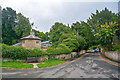
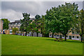
61 photos from this area
Area Information
Key information about the BA2 6DU including its size, population, and administrative classification.
- Area Type
- Postcode
- Area Size
- 3314 m²
- Population
- 4214
- Population Density
- 1522 people/km²
House Prices in BA2 6DU
6
Properties
£620,833
Average Sold Price
£382,500
Lowest Price
£970,000
Highest Price
Showing 6 properties
| Address | Type | Beds | Baths | Last Sale Price | Last Sale Date | |
|---|---|---|---|---|---|---|
| 4 All Saints Place, Claverton Down, Bath, BA2 6DU | Semi-detached | 4 | 1 | £510,000 | Mar 2025 | |
| 3 All Saints Place, Claverton Down, Bath, BA2 6DU | house | - | - | £382,500 | Jun 2021 | |
| 1, Margaret's Buildings, All Saints Place, Claverton Down, Bath, BA2 6DU | Semi-detached | 4 | - | £970,000 | May 2015 | |
| 2, Margaret's Buildings, All Saints Place, Claverton Down, Bath, BA2 6DU | house | 3 | 3 | - | - | |
| The Annexe, 1 All Saints Place, Claverton Down, Bath, BA2 6DU | house | - | - | - | - | |
| 1 All Saints Place, Claverton Down, Bath, BA2 6DU | house | - | - | - | - |
Energy Efficiency in BA2 6DU
Amenities
Schools
| Rank | School | Type | Entry gender | Ages |
|---|
Explore more schools in this area
Go to Schools tabDemographics
Household Size
Two person
most common
Accommodation Type
Houses
most common
Tenure
86
majority
Ethnic Group
White
most common
Religion
N/A
most common
Household Composition
N/A
most common
Age
22
median
Young Adults (15-29 years)
most common
Household Deprivation
N/A
with no deprivation
NS-SEC
15
in Lower managerial occupations
Explore more demographic insights in this area
Go to Demographics tabPlanning
Planning Constraints
- Flood RiskPremium
- Ramsar Wetland SitesPremium
- Area of Outstanding Natural BeautyPremium
- Protected Nature ReservePremium
- Protected WoodlandPremium