Area Overview for BA14 6HA
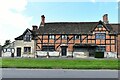
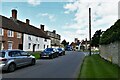
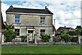
Photos of BA14 6HA

Area Information
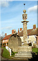
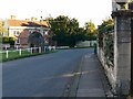
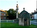
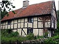
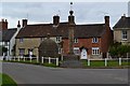
Living in BA14 6HA, Steeple Ashton, offers a quiet residential experience within an area that covers just 2723 square metres. This specific postcode cluster serves a small population of 1505 people, creating a tightly knit community with minimal housing density. You will find yourself in a rural setting where the village takes its name from the historic Church of St Mary the Virgin, although the famous steeple that once dominated the skyline was destroyed by lightning in 1670. The locale traces its roots back to Saxon times, with formal records dating to 964 when the land belonged to King Edgar. Today, the village retains its Saxon character through notable structures such as the manor house built in 1647 and the market cross erected in 1679. Residents enjoy a sense of history embedded in every corner, from the timber-framed Old Merchants Hall to the Longs Pub, which operates within a 16th-century courthouse. Daily life here is defined by proximity to nature and a lack of modern planning constraints, as the area avoids classification as protected woodlands, nature reserves, or Areas of Outstanding Natural Beauty. For those seeking a home without significant environmental restrictions yet rich in local heritage, this spot provides a grounded connection to Wiltshire's past while maintaining a modern, settled pace.
- Area Type
- Postcode
- Area Size
- 2723 m²
- Population
- 1505
- Population Density
- 65 people/km²
The property market in BA14 6HA reflects a deeply established residential zone where 86% of properties are owner-occupied. This high percentage suggests that the local housing stock is primarily comprised of family homes rather than investment rentals or student accommodations. The predominant accommodation type in this postcode is houses, which aligns with the rural nature of Steeple Ashton and its surrounding countryside. Because the area is a small residential cluster covering only 2723 square metres, choices for buyers are naturally limited to a handful of specific properties. This scarcity often means that available homes command a premium and sell quickly once listed. Prospective buyers looking for houses here will likely find properties that have been in the same family for decades, given the low turnover associated with such high ownership rates. While there is no listed data on rental yields or average property prices, the demographic profile indicates a market driven by long-term residence rather than speculative investment. For those who are able to purchase a home, this area offers an opportunity to join a community where property serves as a lasting asset rather than a temporary residence.
House Prices in BA14 6HA
No properties found in this postcode.
Energy Efficiency in BA14 6HA
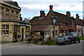
Your daily lifestyle in BA14 6HA revolves around essential amenities that are within practical reach, supported by a historic layout designed for local walking distances. Retail needs are met by five nearby shops, including The Radstock Co-operative Society Co, Budgens Paxcroft, and Budgens Trowbridge. These outlets provide necessary groceries and daily items without the need for car travel, preserving the village's rural character while ensuring convenience. Transport connections rely heavily on rail hubs that include Trowbridge Railway Station, Westbury Railway Station, and Melksham Railway Station, offering regular links to larger regional centres. Historically, the village thrived on trade and markets, a legacy visible in the 1679 market cross that still stands in the village square. The Long family estate once dictated the local economy, and remnants of this wealth survive in buildings like the Manor House and the Longs Pub. Outside, the landscape remains open and undeveloped, devoid of Ramsar wetlands, protected woodlands, or AONB designations, which means you can enjoy views and walks without navigating strict planning restrictions. This combination of nearby high street access and open countryside defines the Steeple Ashton experience for modern residents.
Amenities
Schools
Families considering homes in BA14 6HA have access to locally recognised educational institutions, starting with Keevil CofE Primary School and Steeple Ashton St Mary's Church of England Voluntary Aided Primary School. Both schools are situated nearby to serve the residential cluster's younger population. Ofsted ratings indicate that Keevil CofE Primary School holds a "good" rating, a point of confidence for parents schooling their children in the immediate vicinity. The available data lists these as primary-level options, meaning that families with older children may need to commute to larger towns for secondary education options. The mix of church schools reflects the religious heritage of Steeple Ashton, where the Church of St Mary the Virgin remains a central landmark. While the data does not specify academy trusts or community schools beyond these two entries, the presence of a rated primary school suggests that education is a priority in the area. Parents seeking schools near BA14 6HA will find these options meet the criteria for quality basic education, though they should research secondary pathways separately as no secondary schools are listed in the immediate data set.
| Rank | School | Type | Entry gender | Ages |
|---|
Explore more schools in this area
Go to Schools tabDemographics
The community in BA14 6HA is defined by a mature population with a median age of 47 years. Most residents fall into the adult demographic range between 30 and 64 years old, indicating a neighbourhood of stability rather than transient students or young professionals. A striking 86% of households are owner-occupied, which signals a long-term settlement pattern where families have put down roots rather than renting temporarily. The majority of accommodation consists of houses, reinforcing the suburban or rural character of the location. Demographically, the population is predominantly White, reflecting the traditional makeup of many villages in South West England. This high rate of home ownership typically correlates with lower social mobility but often translates to a quieter, safer environment where neighbours know one another personally. The absence of a large student population or high-turnover rental stock means that local facilities are designed for settled families. If you are considering moving here, you should expect a community where generations have remained in place, fostering strong local bonds and mutual support networks that are rare in faster-paced urban centres.
Household Size
Accommodation Type
Tenure
Ethnic Group
Religion
Household Composition
Age
Household Deprivation
NS-SEC
Explore more demographic insights in this area
Go to Demographics tabPlanning
Planning Constraints
- Flood RiskPremium
- Ramsar Wetland SitesPremium
- Area of Outstanding Natural BeautyPremium
- Protected Nature ReservePremium
- Protected WoodlandPremium