Area Overview for TN27 9TY
Photos of TN27 9TY
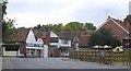

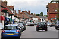
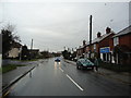
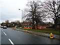
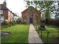
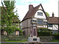

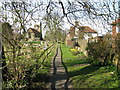
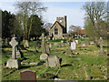


100 photos from this area
Area Information
Key information about the TN27 9TY including its size, population, and administrative classification.
- Area Type
- Postcode
- Area Size
- 7820 m²
- Population
- 1733
- Population Density
- 86 people/km²
House Prices in TN27 9TY
24
Properties
£209,417
Average Sold Price
£95,000
Lowest Price
£285,500
Highest Price
Showing 24 properties
| Address | Type | Beds | Baths | Last Sale Price | Last Sale Date | |
|---|---|---|---|---|---|---|
| 38 Knights Way, Headcorn, TN27 9TY | Maisonette | 2 | 1 | £205,000 | Aug 2024 | |
| 29 Knights Way, Headcorn, TN27 9TY | Terraced | 3 | 1 | £275,000 | Feb 2023 | |
| 34 Knights Way, Headcorn, TN27 9TY | Flat | - | - | £222,000 | Feb 2023 | |
| 52 Knights Way, Headcorn, TN27 9TY | Retail | 3 | 1 | £285,500 | Aug 2022 | |
| 45 Knights Way, Headcorn, TN27 9TY | Maisonette | - | - | £174,000 | May 2021 | |
| 46 Knights Way, Headcorn, TN27 9TY | Semi-detached | - | - | £95,000 | Sep 2002 | |
| 36 Knights Way, Headcorn, TN27 9TY | Maisonette | 2 | 1 | - | - | |
| 30 Knights Way, Headcorn, TN27 9TY | Maisonette | 2 | 1 | - | - | |
| 31 Knights Way, Headcorn, TN27 9TY | house | - | - | - | - | |
| 33 Knights Way, Headcorn, TN27 9TY | Flat | - | - | - | - |
Page 1 of 3
Energy Efficiency in TN27 9TY
Amenities
Schools
| Rank | School | Type | Entry gender | Ages |
|---|
Explore more schools in this area
Go to Schools tabDemographics
Household Size
Two person
most common
Accommodation Type
Houses
most common
Tenure
71
majority
Ethnic Group
White
most common
Religion
N/A
most common
Household Composition
N/A
most common
Age
47
median
Adults (30-64 years)
most common
Household Deprivation
N/A
with no deprivation
NS-SEC
37
in Lower managerial occupations
Explore more demographic insights in this area
Go to Demographics tabPlanning
Planning Constraints
- Flood RiskPremium
- Ramsar Wetland SitesPremium
- Area of Outstanding Natural BeautyPremium
- Protected Nature ReservePremium
- Protected WoodlandPremium